- Archivaliensignatur
-
P 1, 805
- Maße
-
48,4 x 144,8 cm
- Bemerkungen
-
vgl. Oehme S. 104
- Sonstige Erschließungsangaben
-
Identifikation (Karte/Plan): Originaltitel: Danubius fluminum europaeorum princeps ...
Weitere Angaben (Karte/Plan): Ausführung: Papier, auf Leinwand aufgezogen (restauriert 1980); Kupferstich
Weitere Angaben (Karte/Plan): Blattzahl: 1
Vermerke: Deskriptoren: Europa (Mitte) / Donau-Lauf
Vermerke: Deskriptoren: Wille, Paul
- Kontext
-
Alte Karten und Pläne (bis 1918) >> Europa >> Verschiedene europäische Länder >> Osteuropa
- Bestand
-
P 1 Alte Karten und Pläne (bis 1918)
- Urheber
-
P. Willius C. Rhaetus (= Paul Wille)
- Laufzeit
-
1686
- Weitere Objektseiten
- Vorprovenienz
-
Boss, Frieder / Geschenk 1980
- Rechteinformation
-
Es gelten die Nutzungsbedingungen der Staatsarchive in Hessen.
- Letzte Aktualisierung
- 01.07.2025, 11:40 UTC
Datenpartner
Dieses Objekt wird bereitgestellt von:
Hessisches Staatsarchiv Darmstadt. Bei Fragen zum Objekt wenden Sie sich bitte an den Datenpartner.
Hessisches Staatsarchiv Darmstadt. Bei Fragen zum Objekt wenden Sie sich bitte an den Datenpartner.
Objekttyp
- Karte/Plan
Beteiligte
- P. Willius C. Rhaetus (= Paul Wille)
Entstanden
- 1686
Ähnliche Objekte (12)

Laufes, Sybilla
Laufes, Agnes
Laufes, Henricus

D. Uebersichtliche Schilderung des Laufes der Donau
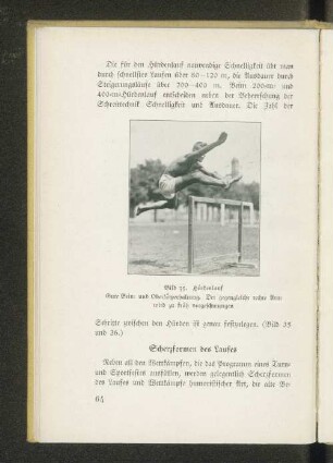
Scherzformen des Laufes
Karte über den Lauf des Emsbachs in der Gemarkung Ennerich
Karte über den Lauf des Lahrbaches in der Gemarkung Lahr (Westerwald)
Karte vom Lauf des Emsbaches bei Niederselters, mit der geplanten Verlegung
Instandhaltung des Weschnitz-Laufes
Instandhaltung des Weschnitz-Laufes
Karte des Laufs des Arheilger Zentbachs in den Gemarkungen Worfelden, Groß-Gerau und Trebur
Karte des Großschifffahrtsweges Rhein-Neckar-Donau im Bereich von Ulm, Augsburg und Donauwörth
Laufes, Sybilla
Laufes, Agnes
Laufes, Henricus
D. Uebersichtliche Schilderung des Laufes der Donau
Scherzformen des Laufes
Karte über den Lauf des Emsbachs in der Gemarkung Ennerich
Karte über den Lauf des Lahrbaches in der Gemarkung Lahr (Westerwald)
Karte vom Lauf des Emsbaches bei Niederselters, mit der geplanten Verlegung
Instandhaltung des Weschnitz-Laufes
Instandhaltung des Weschnitz-Laufes
Karte des Laufs des Arheilger Zentbachs in den Gemarkungen Worfelden, Groß-Gerau und Trebur