
- Umfang
-
1 Kt, [Ca. 1:3.300.000]
- Material
-
Karte
- Sprache
-
Portugiesisch
- Anmerkungen
-
Orig.-Vorlage: Lithogr. - Orig.-Gr.: 36 x 26 cm. - Maßstab in graph. Form (Leguas). - Mit Bergstrichen. - Mit 2 Nebenkt.: Cidade De Curitiba. Topographia da Bahia De Paranaguá
- Erschienen in
-
Atlas do império do Brazil : os mapas de Candido Mendes 1868
- Reihe
-
Altkarten-Projekt des IAI
- Beteiligte Personen und Organisationen
-
Almeida, Cândido Mendes
Schwestka, C.
- Erschienen
-
2000
- PURL
- Letzte Aktualisierung
- 09.05.2025, 13:03 UTC
Datenpartner
Dieses Objekt wird bereitgestellt von:
Ibero-Amerikanisches Institut - Stiftung Preußischer Kulturbesitz. Bei Fragen zum Objekt wenden Sie sich bitte an den Datenpartner.
Ibero-Amerikanisches Institut - Stiftung Preußischer Kulturbesitz. Bei Fragen zum Objekt wenden Sie sich bitte an den Datenpartner.
Objekttyp
- Beigefügtes oder enthaltenes Werk
Beteiligte
- Almeida, Cândido Mendes
- Schwestka, C.
Entstanden
- 2000
Ähnliche Objekte (12)
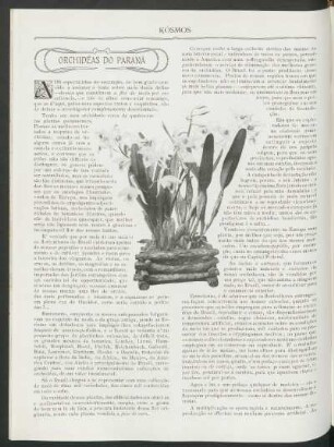
Orchidéas do Paraná
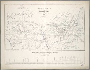
Mappa Geral Da Provincia Do Paraná : com os Caminhos de ferro estudados e projectados
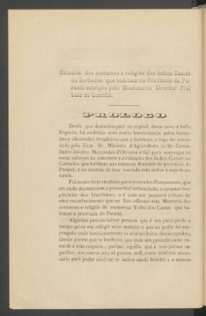
Memória dos costumes e religião dos indios Camés ou Corôados que habitam na Provincia do Paraná

Provincia Do Maranhão

Provincia Do Piauhy

Provincia Do Ceará

Provincia Do Amazonas

Companhia de Terras Norte do Parana

Provincia Do Grão Pará

Provincia Do Municipio Neutro

Provincia Do Espirito Santo

Provincia Do Rio Grande Do Norte
Orchidéas do Paraná
Mappa Geral Da Provincia Do Paraná : com os Caminhos de ferro estudados e projectados
Memória dos costumes e religião dos indios Camés ou Corôados que habitam na Provincia do Paraná
Provincia Do Maranhão
Provincia Do Piauhy
Provincia Do Ceará
Provincia Do Amazonas
Companhia de Terras Norte do Parana
Provincia Do Grão Pará
Provincia Do Municipio Neutro
Provincia Do Espirito Santo