Militärgeschichtliche Karte
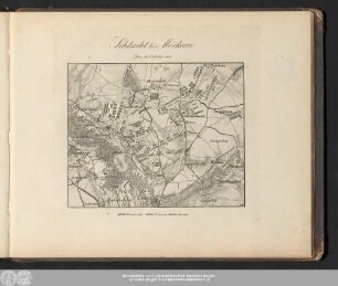
Plan zur Schlacht bei Moeckern, den 16. Oktober 1813
- Alternativer Titel
-
PLAN ZUR SCHLACHT BEI MOECKERN / den 16ten October 1813.
- Standort
-
Deutsches Historisches Museum, Berlin
- Inventarnummer
-
Do 1990/1507
- Maße
-
Höhe x Breite: 53 x 37 cm (Blatt)
Höhe x Breite: 45 x 35,5 cm (Karte)
- Material/Technik
-
Blatt: Papier, auf Leinwand kaschiert, Kupferstich
- Klassifikation
-
Kartografie (Gattung)
- Bezug (was)
-
Befreiungskriege (1813-1815)
- Ereignis
-
Herstellung
- (wo)
-
Deutschland [historisch: Preußen, Königreich]
- (wann)
-
nach 16.10.1813
- Rechteinformation
-
Deutsches Historisches Museum
- Letzte Aktualisierung
- 24.03.2023, 09:29 MEZ
Datenpartner
Dieses Objekt wird bereitgestellt von:
Stiftung Deutsches Historisches Museum. Bei Fragen zum Objekt wenden Sie sich bitte an den Datenpartner.
Stiftung Deutsches Historisches Museum. Bei Fragen zum Objekt wenden Sie sich bitte an den Datenpartner.
Objekttyp
- Militärgeschichtliche Karte
Entstanden
- nach 16.10.1813
Ähnliche Objekte (12)

Plan der Schlacht von Möckern am 16. Oktober 1813

Plan zur Schlacht bei Möckern am 16. Oktober 1813
Plan der Schlacht bei Möckern am 16. Oktober 1813
Schlacht bei Möckern. Den 16. October 1813.
Schlacht bei Moeckern : den 16ten October 1813

Plan zur Schlacht bei Möckern am 16. Oktober 1815

WHK 33 Krieg mit Frankreich 1792-1805: Plan der Schlacht von Möckern, 16. Oktober 1813
Gefechtsplan.- Schlacht bei Möckern am 16. October 1813
Die Schlacht von Möckern am 16ten October 1813
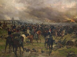
Angriff der Brandenburgischen Husaren in der Schlacht bei Möckern am 16. Oktober 1813

Schlacht bei Möckern

Die Schlacht bei Möckern am 16. Oktober
Plan der Schlacht von Möckern am 16. Oktober 1813
Plan zur Schlacht bei Möckern am 16. Oktober 1813
Plan der Schlacht bei Möckern am 16. Oktober 1813
Schlacht bei Möckern. Den 16. October 1813.
Schlacht bei Moeckern : den 16ten October 1813
Plan zur Schlacht bei Möckern am 16. Oktober 1815
WHK 33 Krieg mit Frankreich 1792-1805: Plan der Schlacht von Möckern, 16. Oktober 1813
Gefechtsplan.- Schlacht bei Möckern am 16. October 1813
Die Schlacht von Möckern am 16ten October 1813
Angriff der Brandenburgischen Husaren in der Schlacht bei Möckern am 16. Oktober 1813
Schlacht bei Möckern