Karten und Pläne
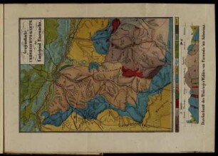
Übersichts-Karte der Verbreitung Jurassischer und Keuperbildungen im nördlichen Bayern. 1:500000. (Sonderdruck aus: Geognostische Beschreibung von Gümbel). 48 x 44 cm
- Archivaliensignatur
-
Forstdirektion Niederbayern-Oberpfalz Kartensammlung 128
- Alt-/Vorsignatur
-
Abgabe Bayerische Staatsforsten 2005/5
- Sprache der Unterlagen
-
ger
- Sonstige Erschließungsangaben
-
Medium: A = Analoges Archivalie
- Kontext
-
Forstdirektion Niederbayern-Oberpfalz Kartensammlung
- Bestand
-
Forstdirektion Niederbayern-Oberpfalz Kartensammlung
- Laufzeit
-
o.J.
- Weitere Objektseiten
- Provenienz
-
Forstdirektion Niederbayern-Oberpfalz Kartensammlung
- Letzte Aktualisierung
- 26.03.2025, 12:05 MEZ
Datenpartner
Dieses Objekt wird bereitgestellt von:
Staatsarchiv Amberg. Bei Fragen zum Objekt wenden Sie sich bitte an den Datenpartner.
Staatsarchiv Amberg. Bei Fragen zum Objekt wenden Sie sich bitte an den Datenpartner.
Objekttyp
- Karten und Pläne
Entstanden
- o.J.
Ähnliche Objekte (12)

Gümbel, C.W. Geognostische-Karte des Königreichs Bayern (4 Blätter). München Gotha. Maßstab 1:500000. 46,5 x 47,5 cm
Freytag-&-Berndt-Autoatlas Ungarn 1:500000 : [Stadtpläne, Ortsverzeichnisse] = Magyarország 1:500000
Geologische Strukturkarte 1:500000
Unterkante Lias 1:500.000
Metallogenetische Karte 1:500.000
Betr. Westdeutschlandkarte 1:500.000
Entwurf e. Strukturkarte 1:500000
Grossbritannien, Irland : Massstab 1:500000
Redaktionsanweisung Tekt. Karte 1:500.000
Reliefkarte Vogtland. ca. 1:500.000
Übersichtsplan Siedlungsverband Ruhrkohlenbezirk. 1:500000
Geognostische Uebersichts-Karte ...
Gümbel, C.W. Geognostische-Karte des Königreichs Bayern (4 Blätter). München Gotha. Maßstab 1:500000. 46,5 x 47,5 cm
Freytag-&-Berndt-Autoatlas Ungarn 1:500000 : [Stadtpläne, Ortsverzeichnisse] = Magyarország 1:500000
Geologische Strukturkarte 1:500000
Unterkante Lias 1:500.000
Metallogenetische Karte 1:500.000
Betr. Westdeutschlandkarte 1:500.000
Entwurf e. Strukturkarte 1:500000
Grossbritannien, Irland : Massstab 1:500000
Redaktionsanweisung Tekt. Karte 1:500.000
Reliefkarte Vogtland. ca. 1:500.000
Übersichtsplan Siedlungsverband Ruhrkohlenbezirk. 1:500000