Militärkarte
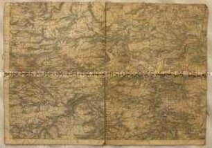
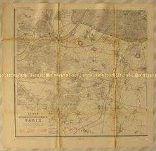
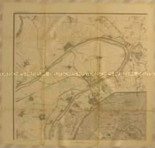
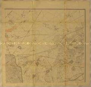
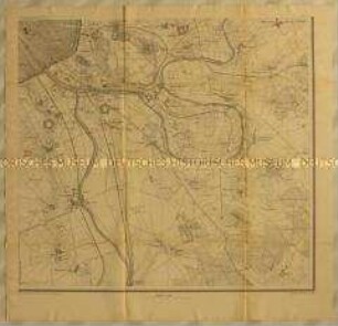
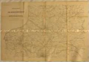
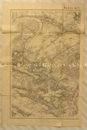
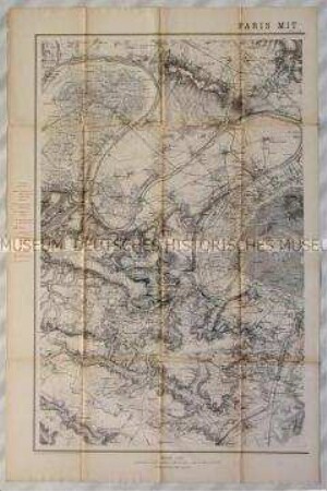
Topographische Teilkarte der Seineschleife zwischen Le Pecq und Chatou in der Region Île-de-France, wohl zu einer Schlacht während des Deutsch-Französischen Krieges
- Location
-
Deutsches Historisches Museum, Berlin
- Inventory number
-
Do 90/9609
- Measurements
-
Höhe x Breite: 19,5 x 45,4 cm (Blatt)
- Material/Technique
-
Druckfarbe (schwarz), Papier, gedruckt
- Classification
-
Landkarten (Gattung)
- Subject (what)
-
Krieg
Militär
- Event
-
Herstellung
- (where)
-
Deutschland ? Frankreich ? [historisch: Deutsches Reich]
- (when)
-
nach 1871
- Rights
-
Deutsches Historisches Museum
- Last update
- 24.03.2023, 9:28 AM CET
Data provider
This object is provided by:
Stiftung Deutsches Historisches Museum. If you have any questions about the object, please contact the data provider.
Stiftung Deutsches Historisches Museum. If you have any questions about the object, please contact the data provider.
Object type
- Militärkarte
Time of origin
- nach 1871
Other Objects (12)
Topographische Teilkarte der Gegend um Naumburg (Karte unvollständig)
Topographische Teilkarte der Gegend südwestlich vor Paris mit den französischen (rot) Befestigungsanlagen bei Sevres, Villejuif und Verrières während des Deutsch-Französischen Krieges
Topographische Teilkarte mit den französischen (rot) Befestigungsanlagen nordwestlich vor Paris bei Neuilly, Asnières, Saint Denis und Argentueil während des Deutsch-Französischen Krieges
Topographische Teilkarte der Gegend nordöstlich vor Paris mit den französischen (rot) Befestigungsanlagen bei Noisy, Stains, Villepinte und Neuilly während des Deutsch-Französischen Krieges

Topographische Teilkarte der Gegend zwischen Freiberg, Frauenstein, Rabenau und Liebstadt im Königreich Sachsen (Karte unvollständig)
Topographische Teilkarte der Gegend südöstlich vor Paris mit den französischen (rot) Befestigungsanlagen vor Charenton und Vincennes sowie der Marneschleife mit Chennevière und Marolles während des Deutsch-Französischen Krieges
Topographische Teilkarte der Gegend westlich von Landau in der Pfalz und Neustadt an der Weinstraße (Karte unvollständig)
Topographische Karte der Gegend um die Garnison Oschatz in Sachsen: Teilkarte des Gebiets zwischen Waldheim, Grimma, Eilenburg und Schildau
Topographische Teilkarte der französischen (rot) und deutschen (blau) Befestigungsanlagen östlich von Paris zwischen St. Brice, Saint Denis, Villeparisis und Crosne
Topographische Karte von Nordfrankreich mit den Heeresbewegungen in der Champagne, Île de France, Picardie, Belgien und der Normandie während des Deutsch-Französischen Krieges
Topographische Teilkarte der französischen (rot) und deutschen (blau) Festungsanlagen westlich von Paris mit der Seineschleife zwischen Maurecourt und Gennevilliers sowie Versailles, Sceaux, Châteaufort und Palaiseau
Topographische Karte der Gegend um Versailles zwischen Châteaufort und Argenteuil südwestlich von Paris mit Anlagen (rot) der Franzosen und (blau) der Deutschen (linke Teilkarte 15 A)
Topographische Teilkarte der Gegend um Naumburg (Karte unvollständig)
Topographische Teilkarte der Gegend südwestlich vor Paris mit den französischen (rot) Befestigungsanlagen bei Sevres, Villejuif und Verrières während des Deutsch-Französischen Krieges
Topographische Teilkarte mit den französischen (rot) Befestigungsanlagen nordwestlich vor Paris bei Neuilly, Asnières, Saint Denis und Argentueil während des Deutsch-Französischen Krieges
Topographische Teilkarte der Gegend nordöstlich vor Paris mit den französischen (rot) Befestigungsanlagen bei Noisy, Stains, Villepinte und Neuilly während des Deutsch-Französischen Krieges
Topographische Teilkarte der Gegend zwischen Freiberg, Frauenstein, Rabenau und Liebstadt im Königreich Sachsen (Karte unvollständig)
Topographische Teilkarte der Gegend südöstlich vor Paris mit den französischen (rot) Befestigungsanlagen vor Charenton und Vincennes sowie der Marneschleife mit Chennevière und Marolles während des Deutsch-Französischen Krieges
Topographische Teilkarte der Gegend westlich von Landau in der Pfalz und Neustadt an der Weinstraße (Karte unvollständig)
Topographische Karte der Gegend um die Garnison Oschatz in Sachsen: Teilkarte des Gebiets zwischen Waldheim, Grimma, Eilenburg und Schildau
Topographische Teilkarte der französischen (rot) und deutschen (blau) Befestigungsanlagen östlich von Paris zwischen St. Brice, Saint Denis, Villeparisis und Crosne
Topographische Karte von Nordfrankreich mit den Heeresbewegungen in der Champagne, Île de France, Picardie, Belgien und der Normandie während des Deutsch-Französischen Krieges
Topographische Teilkarte der französischen (rot) und deutschen (blau) Festungsanlagen westlich von Paris mit der Seineschleife zwischen Maurecourt und Gennevilliers sowie Versailles, Sceaux, Châteaufort und Palaiseau