- Reference number
-
40046 Topographische und Geognostische Karten, Nr. 1-I16 (Zu benutzen im Bergarchiv Freiberg)
- Context
-
40046 Topographische und Geognostische Karten >> 1. Topographische Karte, Deutsches Reich 1:25 000 - Messtischblätter (1900-1935)
- Holding
-
40046 Topographische und Geognostische Karten
- Date of creation
-
aufg. 1903, hrsg. 1905, ngtr. 1911
- Other object pages
- Last update
- 10.12.2025, 3:13 PM CET
Data provider
This object is provided by:
Sächsisches Staatsarchiv. If you have any questions about the object, please contact the data provider.
Sächsisches Staatsarchiv. If you have any questions about the object, please contact the data provider.
Object type
- Karten und Pläne
Time of origin
- aufg. 1903, hrsg. 1905, ngtr. 1911
Other Objects (12)

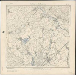
Gröditz - Kröbeln
Gröditz - Kröbeln
Erfassung von Bergbaugebieten - Gröditz / Kröbeln

4546 (alte Nr.: 2614) Gröditz (Kröbeln)
Blatt 2614 Kröbeln, neu: 4546 Gröditz
Übersichtskarte bergschadengefährdeter Gebiete - Kröbeln (bergbehördliches Auflegeblatt)
Übersichtskarte bergschadengefährdeter Gebiete - Kröbeln (topographisches Unterlegblatt)
Sächs. Blatt 8 Gröditz - Preuß. Blatt 2614 Kröbeln, neu: 4546 Gröditz
Section Gröditz - Kröbeln aus: Topographische Karte (Meßtischblätter) Sachsen
Rtg./Sdl. Kröbeln Kröbeln
4546 (alte Nr.: 8/2614) Gröditz (Sächs.)-Kröbeln (Preuß.)
4546 (alte Nr.: 8/2614) Gröditz (Sächs.)-Kröbeln (Preuß.)
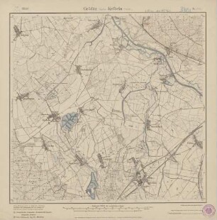
Gröditz - Kröbeln
Gröditz - Kröbeln
Erfassung von Bergbaugebieten - Gröditz / Kröbeln
4546 (alte Nr.: 2614) Gröditz (Kröbeln)
Blatt 2614 Kröbeln, neu: 4546 Gröditz
Übersichtskarte bergschadengefährdeter Gebiete - Kröbeln (bergbehördliches Auflegeblatt)
Übersichtskarte bergschadengefährdeter Gebiete - Kröbeln (topographisches Unterlegblatt)
Sächs. Blatt 8 Gröditz - Preuß. Blatt 2614 Kröbeln, neu: 4546 Gröditz
Section Gröditz - Kröbeln aus: Topographische Karte (Meßtischblätter) Sachsen
Rtg./Sdl. Kröbeln Kröbeln
4546 (alte Nr.: 8/2614) Gröditz (Sächs.)-Kröbeln (Preuß.)
4546 (alte Nr.: 8/2614) Gröditz (Sächs.)-Kröbeln (Preuß.)
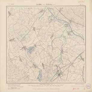
Gröditz - Kröbeln
Gröditz - Kröbeln
Erfassung von Bergbaugebieten - Gröditz / Kröbeln
4546 (alte Nr.: 2614) Gröditz (Kröbeln)
Blatt 2614 Kröbeln, neu: 4546 Gröditz
Übersichtskarte bergschadengefährdeter Gebiete - Kröbeln (bergbehördliches Auflegeblatt)
Übersichtskarte bergschadengefährdeter Gebiete - Kröbeln (topographisches Unterlegblatt)
Sächs. Blatt 8 Gröditz - Preuß. Blatt 2614 Kröbeln, neu: 4546 Gröditz
Section Gröditz - Kröbeln aus: Topographische Karte (Meßtischblätter) Sachsen
Rtg./Sdl. Kröbeln Kröbeln
4546 (alte Nr.: 8/2614) Gröditz (Sächs.)-Kröbeln (Preuß.)