Militärkarte
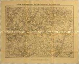
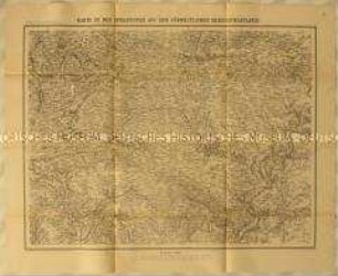
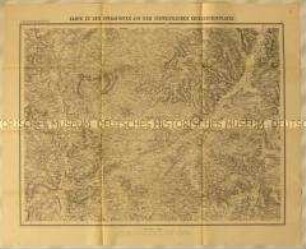
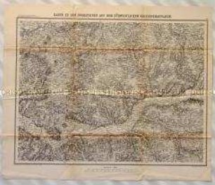
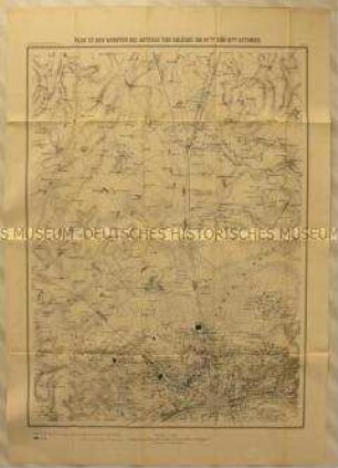
Topographische Karte zur Schlacht bei Dijon als Schauplatz des Deutsch-Französischen Kriegs
- Alternativer Titel
-
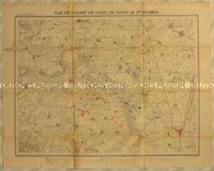
Plan zum Gefecht bei Dijon / am 30sten October.
- Standort
-
Deutsches Historisches Museum, Berlin
- Inventarnummer
-
Do 90/9603
- Maße
-
Höhe x Breite: 30,7 x 32,8 cm (Blatt)
- Material/Technik
-
Druckfarbe (schwarz), Papier, gedruckt
- Klassifikation
-
Landkarten (Gattung)
- Bezug (was)
-
Krieg
Militär
Armee
Eisenbahn
Schlacht
- Ereignis
-
Herstellung
- (wer)
-
Lithograph: Wilhelm Greve
Verlag: Königliche Hofbuchhandlung von Ernst Siegfried Mittler und Sohn
- (wo)
-
Deutschland [historisch: Deutsches Reich]
- (wann)
-
nach 1871
- Rechteinformation
-
Deutsches Historisches Museum
- Letzte Aktualisierung
- 24.03.2023, 08:29 UTC
Datenpartner
Dieses Objekt wird bereitgestellt von:
Stiftung Deutsches Historisches Museum. Bei Fragen zum Objekt wenden Sie sich bitte an den Datenpartner.
Stiftung Deutsches Historisches Museum. Bei Fragen zum Objekt wenden Sie sich bitte an den Datenpartner.
Objekttyp
- Militärkarte
Beteiligte
- Lithograph: Wilhelm Greve
- Verlag: Königliche Hofbuchhandlung von Ernst Siegfried Mittler und Sohn
Entstanden
- nach 1871
Ähnliche Objekte (12)
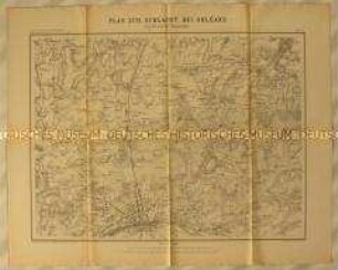
Topographische Karte der Gegend nördlich von Orléans zwischen Escrennes und Orgères als Schauplatz der Schlacht bei Orléans im Deutsch-Französischen Krieg
Topographische Karte der Gegend um Loigny zwischen Janville, Artenay, Guillonville und Fontenay als Schauplatz der Schlacht bei Loigny während des Deutsch-Französischen Krieges
Topographische Karte der Gegend um Amiens zwischen Albert, Montauban, Goyencourt, Conty und Vignacourt als Schauplatz der Schlachten von Amiens und an der Hallue während des Deutsch-Französischen Krieges
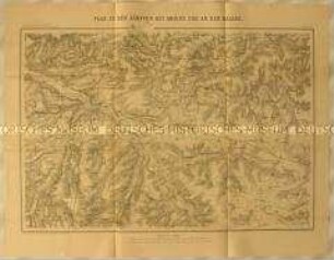
Topographische Karte der Franche-Comté westlich von Montbéliard als Schauplatz des Deutsch-Französischen Kriegs
Topographische Karte der Gegend um Vendôme im Département Eure-et-Loir als südwestlicher Schauplatz des Deutsch-Französischen Krieges
Topographische Karte der Gegend westlich von Châteaudun im Département Eure-et-Loir als südwestlicher Schauplatz des Deutsch-Französischen Krieges

Topographische Karte der Gegend nordwestlich von Beaugency als Schauplatz der Kämpfe bei Meung-sur-Loire und Beaugency während des Deutsch-Französischen Krieges
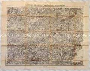
Topographische Karte der Gegend nordöstlich von Le Mans in der Region Pays de la Loire als südwestlicher Schauplatz des Deutsch-Französischen Krieges
Topographische Karte des Département Sarthe zwischen Le Luide, St Paterne, Louestault, Couture, Evaille und Brette als südwestlicher Schauplatz des Deutsch-Französischen Kriegs
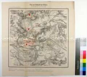
Topographische Karte der Stellungen der deutschen (blau) und französischen (rot) Truppen in der Schlacht bei Villiers während des Deutsch-Französischen Krieges
Topographische Karte der Gegend nördlich von Orléans mit den deutschen (blau) Stellungen während den Schlachten bei Artenay und Orléans im Deutsch-Französischen Krieg
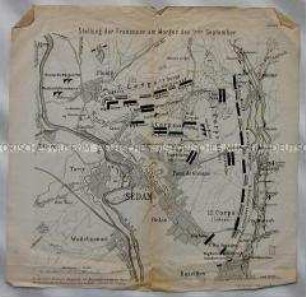
Topographische Karte der französischen Stadt Sedan und Umgebung mit den Stellungen der französischen Truppen am Morgen der Schlacht von Sedan im Deutsch-Französischen Krieg
Topographische Karte der Gegend nördlich von Orléans zwischen Escrennes und Orgères als Schauplatz der Schlacht bei Orléans im Deutsch-Französischen Krieg
Topographische Karte der Gegend um Loigny zwischen Janville, Artenay, Guillonville und Fontenay als Schauplatz der Schlacht bei Loigny während des Deutsch-Französischen Krieges
Topographische Karte der Gegend um Amiens zwischen Albert, Montauban, Goyencourt, Conty und Vignacourt als Schauplatz der Schlachten von Amiens und an der Hallue während des Deutsch-Französischen Krieges
Topographische Karte der Franche-Comté westlich von Montbéliard als Schauplatz des Deutsch-Französischen Kriegs
Topographische Karte der Gegend um Vendôme im Département Eure-et-Loir als südwestlicher Schauplatz des Deutsch-Französischen Krieges
Topographische Karte der Gegend westlich von Châteaudun im Département Eure-et-Loir als südwestlicher Schauplatz des Deutsch-Französischen Krieges
Topographische Karte der Gegend nordwestlich von Beaugency als Schauplatz der Kämpfe bei Meung-sur-Loire und Beaugency während des Deutsch-Französischen Krieges
Topographische Karte der Gegend nordöstlich von Le Mans in der Region Pays de la Loire als südwestlicher Schauplatz des Deutsch-Französischen Krieges
Topographische Karte des Département Sarthe zwischen Le Luide, St Paterne, Louestault, Couture, Evaille und Brette als südwestlicher Schauplatz des Deutsch-Französischen Kriegs
Topographische Karte der Stellungen der deutschen (blau) und französischen (rot) Truppen in der Schlacht bei Villiers während des Deutsch-Französischen Krieges
Topographische Karte der Gegend nördlich von Orléans mit den deutschen (blau) Stellungen während den Schlachten bei Artenay und Orléans im Deutsch-Französischen Krieg