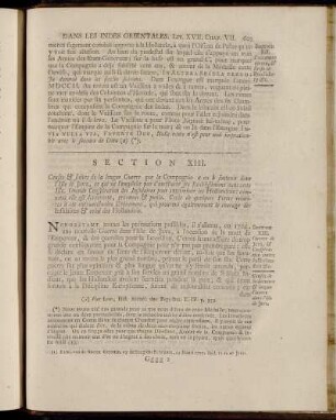
Karte / Plan
Neersen (Kanton) IV: - Gemeinde Süchteln 1: Übersichtskarte 2: Section N Süchteln 3: Section A Hagenbroicherbroich 4: Section B Treibgraben 5: Section C Postelsheide 6: Section D Vorst 7: Section E Sittard 8: Section F Rade 9: Section G Grand-Bois, I 10: Section G Grand-Bois, II 11: Section H Dornbusch 12: Section I Windberg 13: Section K Hagenbroicherhütte 14: Section L Hagenbroich 15: Section M Hagelkreutz
- Reference number
-
BR 0146, R 11
- Dimensions
-
Höhe: 65 cm, Breite: 100 cm, Maßstab: 1:1.250, 1:2.500, 1:10.000
- Context
-
Regierungsbezirk Düsseldorf: Katasterkarten >> 14. Katasterkarten Orte Buchstabe N >> 14.2. Neersen >> 14.2.2. Reinkarten
- Holding
-
BR 0146 Regierungsbezirk Düsseldorf: Katasterkarten
- Date of creation
-
1812
- Other object pages
- Provenance
-
Regierung Düsseldorf
- Delivered via
- Last update
- 09.01.2026, 11:41 AM CET
Data provider
This object is provided by:
Landesarchiv Nordrhein-Westfalen. Abteilung Rheinland. If you have any questions about the object, please contact the data provider.
Landesarchiv Nordrhein-Westfalen. Abteilung Rheinland. If you have any questions about the object, please contact the data provider.
Object type
- Karten / Pläne
Time of origin
- 1812
Other Objects (12)
![[Flurkartenatlas: Übersichtskarte; Section A Hagenbroicherbroich; Section B Treibgraben; Section C Postelsheide; Section D Vors; Section E Sittard; Section F Rade; Section G Grand-Bois [=Süchtelner Busch] in 2 Blättern u. 4 Supplementblättern Erbenwald; Section H Dornbusch; Section I Windberg; Section K Hagenbroicherhütte; Section L Hagenbroich; Section M Hagelkreutz; Section N Süchteln. Mit Niers und Nordkanal]](/assets/placeholder/searchResultMediaNoDigitisedMedia.png)
[Flurkartenatlas: Übersichtskarte; Section A Hagenbroicherbroich; Section B Treibgraben; Section C Postelsheide; Section D Vors; Section E Sittard; Section F Rade; Section G Grand-Bois [=Süchtelner Busch] in 2 Blättern u. 4 Supplementblättern Erbenwald; Section H Dornbusch; Section I Windberg; Section K Hagenbroicherhütte; Section L Hagenbroich; Section M Hagelkreutz; Section N Süchteln. Mit Niers und Nordkanal]

Section I. - Section II.

Section I. - Section III.
Section XIII. - Section XV.

Section X. - Section XII.

Section VI. - Section IX.

Section I. - Section V.

Section IV. - Section VII.

Section V. - Section VI.

Section VI. - Section IX.
Section I. - Section III.

Section I. - Section III.
[Flurkartenatlas: Übersichtskarte; Section A Hagenbroicherbroich; Section B Treibgraben; Section C Postelsheide; Section D Vors; Section E Sittard; Section F Rade; Section G Grand-Bois [=Süchtelner Busch] in 2 Blättern u. 4 Supplementblättern Erbenwald; Section H Dornbusch; Section I Windberg; Section K Hagenbroicherhütte; Section L Hagenbroich; Section M Hagelkreutz; Section N Süchteln. Mit Niers und Nordkanal]
Section I. - Section II.
Section I. - Section III.
Section XIII. - Section XV.
Section X. - Section XII.
Section VI. - Section IX.
Section I. - Section V.
Section IV. - Section VII.
Section V. - Section VI.
Section VI. - Section IX.
Section I. - Section III.
Section I. - Section III.
[Flurkartenatlas: Übersichtskarte; Section A Hagenbroicherbroich; Section B Treibgraben; Section C Postelsheide; Section D Vors; Section E Sittard; Section F Rade; Section G Grand-Bois [=Süchtelner Busch] in 2 Blättern u. 4 Supplementblättern Erbenwald; Section H Dornbusch; Section I Windberg; Section K Hagenbroicherhütte; Section L Hagenbroich; Section M Hagelkreutz; Section N Süchteln. Mit Niers und Nordkanal]
Section I. - Section II.
Section I. - Section III.
Section XIII. - Section XV.
Section X. - Section XII.
Section VI. - Section IX.
Section I. - Section V.
Section IV. - Section VII.
Section V. - Section VI.
Section VI. - Section IX.
Section I. - Section III.