- Reference number
-
D 73, 4/5184
- Dimensions
-
Höhe: 67, Breite: 52, Maßstab: 1:1.000
- Context
-
Allgemeine Kartensammlung (bisherige Kartei) >> 22. Tit. 4 (noch nicht klassifiziert) >> 22.12. Nr. 5001 - 5200
- Holding
-
D 73 Allgemeine Kartensammlung (bisherige Kartei)
- Date of creation
-
1895/1897
- Other object pages
- Provenance
-
Behörden, Institutionen, Einzelpersonen (Sammlungen)
- Delivered via
- Last update
- 05.11.2025, 3:36 PM CET
Data provider
This object is provided by:
Landesarchiv Nordrhein-Westfalen. Abteilung Ostwestfalen-Lippe. If you have any questions about the object, please contact the data provider.
Landesarchiv Nordrhein-Westfalen. Abteilung Ostwestfalen-Lippe. If you have any questions about the object, please contact the data provider.
Object type
- Karten / Pläne
Time of origin
- 1895/1897
Other Objects (12)

Bebauungsplan des Papenbergs (in Detmold); Nivellementspläne VI, VIIa, VIIb,. auf Transparent, Längenmaßstab 1:1.000, Höhenmaßstab 1:200
Bebauungsplan des Papenbergs (in Detmold); Nivellementspläne 1 bis 5. auf Transparent, Längenmaßstab 1:1.000, Höhenmaßstab 1:200
Bebauungsplan für den Bereich Mühlenwiese in Detmold,. auf Transparent
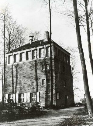
Wasserturm Papenberg und Turmcafe. Detmold
Stadtplan von Detmold,. auf Transparent
Bebauungsplan vom Hiddeser Berg; auf Transparent
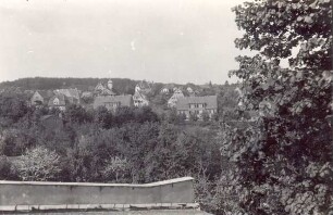
Blick auf den Papenberg. Detmold. Papenbergweg
Flurkarte von Detmold,. mit Eintragungen, auf Transparent
Profil der Bahnlinie durch Detmold; auf Transparent
Bebauungsplan der Stadt Detmold
Fluchtlinienplan für den Wall (in Detmold),. auf Transparent
Fluchtlinienplan für die Ausguststraße (in Detmold),. auf Transparent
Bebauungsplan des Papenbergs (in Detmold); Nivellementspläne VI, VIIa, VIIb,. auf Transparent, Längenmaßstab 1:1.000, Höhenmaßstab 1:200
Bebauungsplan des Papenbergs (in Detmold); Nivellementspläne 1 bis 5. auf Transparent, Längenmaßstab 1:1.000, Höhenmaßstab 1:200
Bebauungsplan für den Bereich Mühlenwiese in Detmold,. auf Transparent
Wasserturm Papenberg und Turmcafe. Detmold
Stadtplan von Detmold,. auf Transparent
Bebauungsplan vom Hiddeser Berg; auf Transparent
Blick auf den Papenberg. Detmold. Papenbergweg
Flurkarte von Detmold,. mit Eintragungen, auf Transparent
Profil der Bahnlinie durch Detmold; auf Transparent
Bebauungsplan der Stadt Detmold
Fluchtlinienplan für den Wall (in Detmold),. auf Transparent