Verzeichnung
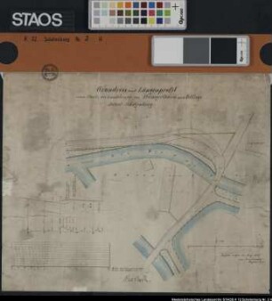
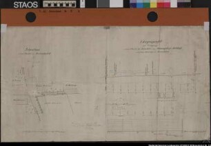
Grundriss und Längenprofil eines Teils der Landstraße Melle-Oldendorf im Stadtbezirk Melle Ausf.-Art: Farbige Zeichnung Herst.: Brockmeyer Format: 35 x 49 cm Maßstab: 1 : 1000
- Reference number
-
NLA OS, K, 42 Melle Nr. 16 H
- Former reference number
-
Organisations- und Aktenzeichen: aus Dep 73 b, Nr. 1071
- Further information
-
Ergänzungen: Klassifikation TeilB: melle
- Context
-
Karten >> 5 Regierungsbezirk Weser-Ems >> 5.13 Landkreis Osnabrück >> 5.13.5 Feldmarken, Stadt- und Ortspläne, Flurstücke >> 5.13.5.18 Stadt Melle
- Holding
-
NLA OS, K Karten
- Indexentry person
-
Brockmeyer
- Indexentry place
-
Melle, Stadtbezirk, Melle-Oldendorf, Landstraße
- Date of creation
-
- 1873
- Last update
- 16.06.2025, 11:09 AM CEST
Data provider
This object is provided by:
Niedersächsisches Landesarchiv.
If you have any questions about the object, please contact the data provider.
Object type
- Verzeichnung
Time of origin
- - 1873
Other Objects (12)
"Grundriß und Längenprofil eines Teiles der Landstraße von Steiningerturm nach Wittlage. Abtlg. Schelenburg" Teil der Wierau und Schloss Schelenburg Ausf.-Art: Farbige Zeichnung Herst.: Brockmeyer Format: 34 x 41 cm Maßstab: 1 : 500 (Grundriss), 1 : 200 (Höhe), 1 : 2000 (Länge)
Situations- und Längenprofil "zur Verlegung eines Teiles der Landstraße von Schwagstorf nach Holdorf nach dem Bahnhofe vor Bersenbrück". Die Abzweigung in Bersenbrück bei der Oberförsterei zum Bahnhof. Namen der anliegenden Grundbesitzer Ausf.-Art: Farbige Zeichnung Herst.: Brockmeyer Format: 39 x 701 cm Maßstab: 1 : 200 - 2000
Grundstücke und Gebäude an der Mühlenstraße und am Alten Greetsieler Sieltief in GREETSIEL Kolorierte Zeichnung von Brockmeyer Papier Format 45,2x18,7 M 1:3.000
Plan zur Grenzbestimmung zwischen der Kirche und dem Haus von I. C. Dieken in PEWSUM Kolorierte Zeichnung von Brockmeyer Papier Format 53,0x36,0 M 1:500

Experimentalphysik, Bd. 1.. Mechanik der Massenpunkte und des starren Körpers
Ost-West-Beziehungen, Bd. 3
Strafvollzug, von Studenten gesehen : Referate über Themen d. Strafvollzuges u. Berichte über e. siebentägige Exkursion in Justizvollzugsanstalten Niedersachsens.
Die Erzählung in der Geschichtsmethodik von SBZ und DDR, Quellenbd.
Rechnungswesen, Bd. 2.. Pagatorische und kalkulatorische Erfolgsrechnung
Experimentalphysik, Bd. 1.. Mechanik der Massenpunkte und des starren Körpers
Von vielem Geist und großer Herzensgüte : Mathilde Franziska Anneke (1817-1884)
Spielarten der Natürlichkeit - Spielarten der Ökonomie, Halbbd. 1
"Grundriß und Längenprofil eines Teiles der Landstraße von Steiningerturm nach Wittlage. Abtlg. Schelenburg" Teil der Wierau und Schloss Schelenburg Ausf.-Art: Farbige Zeichnung Herst.: Brockmeyer Format: 34 x 41 cm Maßstab: 1 : 500 (Grundriss), 1 : 200 (Höhe), 1 : 2000 (Länge)
Situations- und Längenprofil "zur Verlegung eines Teiles der Landstraße von Schwagstorf nach Holdorf nach dem Bahnhofe vor Bersenbrück". Die Abzweigung in Bersenbrück bei der Oberförsterei zum Bahnhof. Namen der anliegenden Grundbesitzer Ausf.-Art: Farbige Zeichnung Herst.: Brockmeyer Format: 39 x 701 cm Maßstab: 1 : 200 - 2000
Grundstücke und Gebäude an der Mühlenstraße und am Alten Greetsieler Sieltief in GREETSIEL Kolorierte Zeichnung von Brockmeyer Papier Format 45,2x18,7 M 1:3.000
Plan zur Grenzbestimmung zwischen der Kirche und dem Haus von I. C. Dieken in PEWSUM Kolorierte Zeichnung von Brockmeyer Papier Format 53,0x36,0 M 1:500
Experimentalphysik, Bd. 1.. Mechanik der Massenpunkte und des starren Körpers
Ost-West-Beziehungen, Bd. 3
Strafvollzug, von Studenten gesehen : Referate über Themen d. Strafvollzuges u. Berichte über e. siebentägige Exkursion in Justizvollzugsanstalten Niedersachsens.
Die Erzählung in der Geschichtsmethodik von SBZ und DDR, Quellenbd.
Rechnungswesen, Bd. 2.. Pagatorische und kalkulatorische Erfolgsrechnung
Experimentalphysik, Bd. 1.. Mechanik der Massenpunkte und des starren Körpers
Von vielem Geist und großer Herzensgüte : Mathilde Franziska Anneke (1817-1884)