- Alternative title
-
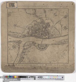
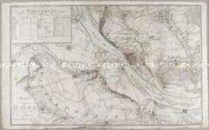
PLAN / der Stadt und Vestung / MAYNZ / und ihrer Gegend
- Location
-
Deutsches Historisches Museum, Berlin
- Inventory number
-
Do 2006/713
- Measurements
-
Höhe x Breite: 58 x 74 cm (Blatt)
Höhe x Breite: 52 x 60,5 cm (Karte)
Höhe x Breite: 55 x 64 cm (Platte)
- Material/Technique
-
Papier, Kupferstich, teilkoloriert
- Classification
-
Kartografie (Gattung)
- Subject (what)
-
Mainz
Belagerung
Koalitionskrieg (1792-1797)
- Event
-
Herstellung
- (who)
-
Stecher: Johannes Conrad Friedrich Felsing
Kartograf: Johann N. Arnould
Verlag: Varrentrapp und Wenner
- (where)
-
Darmstadt, Deutschland
- (when)
-
um 1795
- Rights
-
Deutsches Historisches Museum
- Last update
- 24.03.2023, 9:31 AM CET
Data provider
This object is provided by:
Stiftung Deutsches Historisches Museum. If you have any questions about the object, please contact the data provider.
Stiftung Deutsches Historisches Museum. If you have any questions about the object, please contact the data provider.
Object type
- Belagerungskarte
Associated
- Stecher: Johannes Conrad Friedrich Felsing
- Kartograf: Johann N. Arnould
- Verlag: Varrentrapp und Wenner
Time of origin
- um 1795
Other Objects (12)
Neuer Plan von der Stadt und Vestung Maynz, Cassel und umliegen Gegend.
Plan der Stadt Maynz
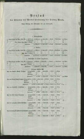
Verlust der Alliirten bey Wieder-Eroberung der Vestung Maynz
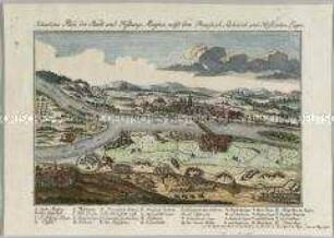
Situations Plan der Stadt und Festung Maynz
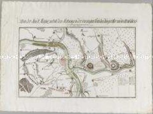
Plan der Belagerung von Maynz
Maynz
Maynz

Maynz

Maynz

Maynz
III. Maynz

III. Maynz
Neuer Plan von der Stadt und Vestung Maynz, Cassel und umliegen Gegend.
Plan der Stadt Maynz
Verlust der Alliirten bey Wieder-Eroberung der Vestung Maynz
Situations Plan der Stadt und Festung Maynz
Plan der Belagerung von Maynz
Maynz
Maynz
Maynz
Maynz
Maynz
III. Maynz
III. Maynz
Neuer Plan von der Stadt und Vestung Maynz, Cassel und umliegen Gegend.
Plan der Stadt Maynz
Verlust der Alliirten bey Wieder-Eroberung der Vestung Maynz
Situations Plan der Stadt und Festung Maynz
Plan der Belagerung von Maynz
Maynz
Maynz
Maynz
Maynz
Maynz
III. Maynz