Politisch-administrative Karte
Politisch-administrative Karte von Ostafrika (Abessinien und Somali-Land)
- Alternative title
-
Karte von Abessinien
- Location
-
Deutsches Historisches Museum, Berlin
- Inventory number
-
DG 90/9537
- Measurements
-
Höhe x Breite: 28,8 x 39,8 cm
- Material/Technique
-
Papier, gedruckt
- Classification
-
Kartografie (Gattung)
- Subject (what)
-
Geographie
Abessinien (Kaiserreich, 980 v.Chr.-1974)
- Event
-
Herstellung
- (who)
-
Verlag: Rudolf Lorenz Verlag
- (where)
-
Berlin, Deutschland [historisch: Deutsches Reich]
- (when)
-
um 1936
- Rights
-
Deutsches Historisches Museum
- Last update
- 24.03.2023, 9:27 AM CET
Data provider
This object is provided by:
Stiftung Deutsches Historisches Museum. If you have any questions about the object, please contact the data provider.
Stiftung Deutsches Historisches Museum. If you have any questions about the object, please contact the data provider.
Object type
- Politisch-administrative Karte
Associated
- Verlag: Rudolf Lorenz Verlag
Time of origin
- um 1936
Other Objects (12)

Afrika ..., 21. Somali-Land
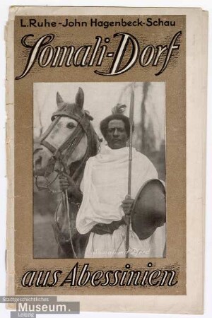
Somali-Dorf aus Abessinien
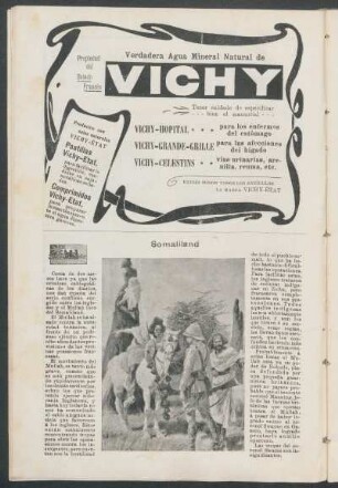
Somaliland

Somaliland

List of mammals from Somali-Land obtained by the museum's East African expedition

Grenzregulierungen zwischen Abessinien und Britisch-Ostafrika
Review: Michael Walls (2014), A Somali Nation-State: History, Culture and Somaliland's Political Transition
Somaliland Protectorate
Somaliland Protectorate.

Somaliland Protectorate
Somaliland Protectorate
Somaliland Protectorate
Afrika ..., 21. Somali-Land
Somali-Dorf aus Abessinien
Somaliland
Somaliland
List of mammals from Somali-Land obtained by the museum's East African expedition
Grenzregulierungen zwischen Abessinien und Britisch-Ostafrika
Review: Michael Walls (2014), A Somali Nation-State: History, Culture and Somaliland's Political Transition
Somaliland Protectorate
Somaliland Protectorate.
Somaliland Protectorate
Somaliland Protectorate
Somaliland Protectorate
Afrika ..., 21. Somali-Land
Somali-Dorf aus Abessinien
Somaliland
Somaliland
List of mammals from Somali-Land obtained by the museum's East African expedition
Grenzregulierungen zwischen Abessinien und Britisch-Ostafrika
Review: Michael Walls (2014), A Somali Nation-State: History, Culture and Somaliland's Political Transition
Somaliland Protectorate
Somaliland Protectorate.
Somaliland Protectorate
Somaliland Protectorate