Karte | map
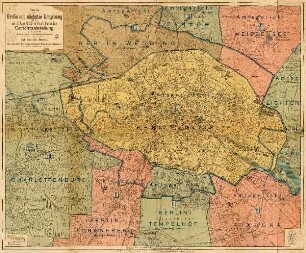
Neuester Plan von Berlin : mit den Königl. Preuss. Standes- und Amtsbezirks-Superintendentur- und Parochie-Grenzen

- Location
-
Zentral- und Landesbibliothek Berlin -- B 54/1874/2
- Extent
-
1 Kt.
- Language
-
Deutsch
- Contributor
-
Straube, Julius
- Published
-
Berlin : Straube , 1874
- URN
-
urn:nbn:de:kobv:109-opus-104315
- Last update
- 05.06.2025, 3:28 PM CEST
Data provider
This object is provided by:
Zentral- und Landesbibliothek Berlin. If you have any questions about the object, please contact the data provider.
Zentral- und Landesbibliothek Berlin. If you have any questions about the object, please contact the data provider.
Object type
- map ; Karte
Associated
- Straube, Julius
Time of origin
- Berlin : Straube , 1874
Other Objects (12)
Karte von Berlin und nächster Umgebung mit der am 1. Juni 1906 in Kraft tretenden Gerichtseinteilung
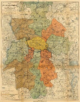
Karte von Berlin und weiterer Umgebung mit der am 1. Juni 1906 in Kraft tretenden Gerichtseinteilung : nebst Darstellung der Amts- und Gemeinde-Bezirksgrenzen

Eine Hand voll Nacht, Buch.

Die Unabhängigkeit des Papstthums : Vom Standpunkte des Christenthums und des europäischen Staatsrechts beleuchtet von einem katholischen Laien

Des aufmerksamen Thüringers neueste Reisen durch die Welt : Worinnen der itzige Zustand der Höfe, die Verfassung und Merkwürdigkeiten ihrer Staaten, Lebens-Geschichte, Anecdoten hoher und berühmter Personen, nebst andern Denkwürdigkeiten beschrieben und aus den Geschichten, dem Natur-Reiche, der Oeconomie, Litteratur, Alterthümer, Münzen und Künsten erklärt werden ; Zur Erläuterung der neuesten Weltbegebenheiten, 5

Des aufmerksamen Thüringers neueste Reisen durch die Welt : Worinnen der itzige Zustand der Höfe, die Verfassung und Merkwürdigkeiten ihrer Staaten, Lebens-Geschichte, Anecdoten hoher und berühmter Personen, nebst andern Denkwürdigkeiten beschrieben und aus den Geschichten, dem Natur-Reiche, der Oeconomie, Litteratur, Alterthümer, Münzen und Künsten erklärt werden ; Zur Erläuterung der neuesten Weltbegebenheiten, 1

Des aufmerksamen Thüringers neueste Reisen durch die Welt : Worinnen der itzige Zustand der Höfe, die Verfassung und Merkwürdigkeiten ihrer Staaten, Lebens-Geschichte, Anecdoten hoher und berühmter Personen, nebst andern Denkwürdigkeiten beschrieben und aus den Geschichten, dem Natur-Reiche, der Oeconomie, Litteratur, Alterthümer, Münzen und Künsten erklärt werden ; Zur Erläuterung der neuesten Weltbegebenheiten, 4

Der historische Zeitvertreiber, mit moralischen Anmerkungen begleitet
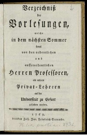
Verzeichniß der Vorlesungen, welche in dem nächsten Sommer sowol von den ordentlichen und ausserordentlichen Herren Professoren, als andern Privat-Lehrern auf der Universität zu Erfurt gehalten werden

Des aufmerksamen Thüringers neueste Reisen durch die Welt : Worinnen der itzige Zustand der Höfe, die Verfassung und Merkwürdigkeiten ihrer Staaten, Lebens-Geschichte, Anecdoten hoher und berühmter Personen, nebst andern Denkwürdigkeiten beschrieben und aus den Geschichten, dem Natur-Reiche, der Oeconomie, Litteratur, Alterthümer, Münzen und Künsten erklärt werden ; Zur Erläuterung der neuesten Weltbegebenheiten, 2

Des aufmerksamen Thüringers neueste Reisen durch die Welt : Worinnen der itzige Zustand der Höfe, die Verfassung und Merkwürdigkeiten ihrer Staaten, Lebens-Geschichte, Anecdoten hoher und berühmter Personen, nebst andern Denkwürdigkeiten beschrieben und aus den Geschichten, dem Natur-Reiche, der Oeconomie, Litteratur, Alterthümer, Münzen und Künsten erklärt werden ; Zur Erläuterung der neuesten Weltbegebenheiten, 6

Des aufmerksamen Thüringers neueste Reisen durch die Welt : Worinnen der itzige Zustand der Höfe, die Verfassung und Merkwürdigkeiten ihrer Staaten, Lebens-Geschichte, Anecdoten hoher und berühmter Personen, nebst andern Denkwürdigkeiten beschrieben und aus den Geschichten, dem Natur-Reiche, der Oeconomie, Litteratur, Alterthümer, Münzen und Künsten erklärt werden ; Zur Erläuterung der neuesten Weltbegebenheiten, 3
Karte von Berlin und nächster Umgebung mit der am 1. Juni 1906 in Kraft tretenden Gerichtseinteilung
Karte von Berlin und weiterer Umgebung mit der am 1. Juni 1906 in Kraft tretenden Gerichtseinteilung : nebst Darstellung der Amts- und Gemeinde-Bezirksgrenzen
Eine Hand voll Nacht, Buch.
Die Unabhängigkeit des Papstthums : Vom Standpunkte des Christenthums und des europäischen Staatsrechts beleuchtet von einem katholischen Laien
Des aufmerksamen Thüringers neueste Reisen durch die Welt : Worinnen der itzige Zustand der Höfe, die Verfassung und Merkwürdigkeiten ihrer Staaten, Lebens-Geschichte, Anecdoten hoher und berühmter Personen, nebst andern Denkwürdigkeiten beschrieben und aus den Geschichten, dem Natur-Reiche, der Oeconomie, Litteratur, Alterthümer, Münzen und Künsten erklärt werden ; Zur Erläuterung der neuesten Weltbegebenheiten, 5
Des aufmerksamen Thüringers neueste Reisen durch die Welt : Worinnen der itzige Zustand der Höfe, die Verfassung und Merkwürdigkeiten ihrer Staaten, Lebens-Geschichte, Anecdoten hoher und berühmter Personen, nebst andern Denkwürdigkeiten beschrieben und aus den Geschichten, dem Natur-Reiche, der Oeconomie, Litteratur, Alterthümer, Münzen und Künsten erklärt werden ; Zur Erläuterung der neuesten Weltbegebenheiten, 1
Des aufmerksamen Thüringers neueste Reisen durch die Welt : Worinnen der itzige Zustand der Höfe, die Verfassung und Merkwürdigkeiten ihrer Staaten, Lebens-Geschichte, Anecdoten hoher und berühmter Personen, nebst andern Denkwürdigkeiten beschrieben und aus den Geschichten, dem Natur-Reiche, der Oeconomie, Litteratur, Alterthümer, Münzen und Künsten erklärt werden ; Zur Erläuterung der neuesten Weltbegebenheiten, 4
Der historische Zeitvertreiber, mit moralischen Anmerkungen begleitet
Verzeichniß der Vorlesungen, welche in dem nächsten Sommer sowol von den ordentlichen und ausserordentlichen Herren Professoren, als andern Privat-Lehrern auf der Universität zu Erfurt gehalten werden
Des aufmerksamen Thüringers neueste Reisen durch die Welt : Worinnen der itzige Zustand der Höfe, die Verfassung und Merkwürdigkeiten ihrer Staaten, Lebens-Geschichte, Anecdoten hoher und berühmter Personen, nebst andern Denkwürdigkeiten beschrieben und aus den Geschichten, dem Natur-Reiche, der Oeconomie, Litteratur, Alterthümer, Münzen und Künsten erklärt werden ; Zur Erläuterung der neuesten Weltbegebenheiten, 2
Des aufmerksamen Thüringers neueste Reisen durch die Welt : Worinnen der itzige Zustand der Höfe, die Verfassung und Merkwürdigkeiten ihrer Staaten, Lebens-Geschichte, Anecdoten hoher und berühmter Personen, nebst andern Denkwürdigkeiten beschrieben und aus den Geschichten, dem Natur-Reiche, der Oeconomie, Litteratur, Alterthümer, Münzen und Künsten erklärt werden ; Zur Erläuterung der neuesten Weltbegebenheiten, 6