- Alternative title
-
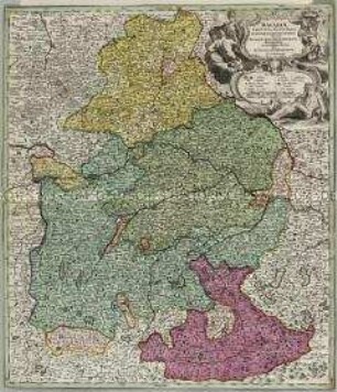
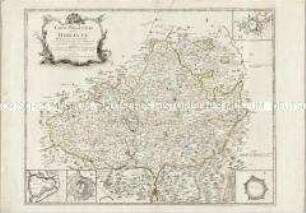
CARTE / DU DUCHÉ ET ELECTORAT / DE BAVIÈRE, / avec toutes ses Dépendances;
- Location
-
Deutsches Historisches Museum, Berlin
- Inventory number
-
Do 2006/1233
- Measurements
-
Höhe x Breite: 53 x 68 cm (Blatt)
Höhe x Breite: 39 x 45,5 cm (Karte)
Höhe x Breite: 43,3 x 49,6 cm (Platte)
- Material/Technique
-
Papier, Kupferstich, koloriert
- Classification
-
Kartografie (Gattung)
- Subject (what)
-
Bayern
Bayerischer Reichskreis
- Event
-
Herstellung
- (who)
-
Geograph, Kartograf: Louis Brion de la Tour (1792)
Stecher: Gobert-Denis Chambon
Verlag: Esnauts et Rapilly
- (where)
-
Paris, Frankreich
- (when)
-
1779
- Rights
-
Deutsches Historisches Museum
- Last update
- 24.03.2023, 9:28 AM CET
Data provider
This object is provided by:
Stiftung Deutsches Historisches Museum. If you have any questions about the object, please contact the data provider.
Stiftung Deutsches Historisches Museum. If you have any questions about the object, please contact the data provider.
Object type
- Kreiskarte
Associated
- Geograph, Kartograf: Louis Brion de la Tour (1792)
- Stecher: Gobert-Denis Chambon
- Verlag: Esnauts et Rapilly
Time of origin
- 1779
Other Objects (12)
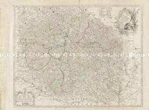
Bavariae Circulus et Electorat.

Le Cercle de Baviere
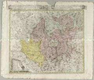
Carte Generale du Royaume de Boheme du Duché de Silesie et des Marquisats de Moravie et de Lusace
![Karte der Oberlausitz, Kupferstich, 1789 : Carte Topographique D'Allemagne : Contenant une Partie de l'Electorat de Saxe la Lusace Superieure, les Extrêmités du Rauyome de Boheme ; A. P. de S. M. I.- / Fait par I. u. K.. - Francfort : Iaeger , [um 1789]. - 1 Kt. : kolor. Kupferst. ; 59 x 46 cm](https://iiif.deutsche-digitale-bibliothek.de/image/2/01de9c66-9701-4e9e-82f4-fe712d7286a4/full/!306,450/0/default.jpg)
Karte der Oberlausitz, Kupferstich, 1789 : Carte Topographique D'Allemagne : Contenant une Partie de l'Electorat de Saxe la Lusace Superieure, les Extrêmités du Rauyome de Boheme ; A. P. de S. M. I.- / Fait par I. u. K.. - Francfort : Iaeger , [um 1789]. - 1 Kt. : kolor. Kupferst. ; 59 x 46 cm

Carte Nouvelle du Gouvernement Général de la Champagne
Carte des Cercles du Haut et du Bas Rhin
Carte du Gouvernement de Normandie. Mit einer Nebenkarte (Kanalinseln)

Carte de la République Française. Mit einer Nebenkarte: Isle de Corse
Carte particuliere de la Moravie. Mit vier Stadtplänen: Brunn; Olmutz; Iglaw; Neustatt
Le Royaume de Boheme. Carte reduite sur celle de 25 feuilles faite a Prague
Atlas Regni Bohemiae: Repraesentatio Geographica Circuli Egerani, nec non Elnbogensis / Carte du Territoire d'Egra, & du Cercle d'Elnbogue
![Karte vom Kreis Bautzen, ca. 1:180 000, Kupferstich, 1746 : Geographische Verzeichnung des Budissinischen Creises in dem Marggrafthum Ober-Lausitz = Carte du Cercle de Budissin dans le Marggrafiat de la Haute Lusace / aus zuversichtlichen geodetischen Zeichnungen genommen und ans Licht gestellet von Homaennischen Erben. - [Ca. 1:180 000]. - [Nürnberg] , 1746. - 1 Kt. : kolor. Kupferst. ; 45 x 41 cm](https://iiif.deutsche-digitale-bibliothek.de/image/2/9c220b96-421b-48dd-8bba-1097578230d9/full/!306,450/0/default.jpg)
Karte vom Kreis Bautzen, ca. 1:180 000, Kupferstich, 1746 : Geographische Verzeichnung des Budissinischen Creises in dem Marggrafthum Ober-Lausitz = Carte du Cercle de Budissin dans le Marggrafiat de la Haute Lusace / aus zuversichtlichen geodetischen Zeichnungen genommen und ans Licht gestellet von Homaennischen Erben. - [Ca. 1:180 000]. - [Nürnberg] , 1746. - 1 Kt. : kolor. Kupferst. ; 45 x 41 cm
Bavariae Circulus et Electorat.
Le Cercle de Baviere
Carte Generale du Royaume de Boheme du Duché de Silesie et des Marquisats de Moravie et de Lusace
Karte der Oberlausitz, Kupferstich, 1789 : Carte Topographique D'Allemagne : Contenant une Partie de l'Electorat de Saxe la Lusace Superieure, les Extrêmités du Rauyome de Boheme ; A. P. de S. M. I.- / Fait par I. u. K.. - Francfort : Iaeger , [um 1789]. - 1 Kt. : kolor. Kupferst. ; 59 x 46 cm
Carte Nouvelle du Gouvernement Général de la Champagne
Carte des Cercles du Haut et du Bas Rhin
Carte du Gouvernement de Normandie. Mit einer Nebenkarte (Kanalinseln)
Carte de la République Française. Mit einer Nebenkarte: Isle de Corse
Carte particuliere de la Moravie. Mit vier Stadtplänen: Brunn; Olmutz; Iglaw; Neustatt
Le Royaume de Boheme. Carte reduite sur celle de 25 feuilles faite a Prague
Atlas Regni Bohemiae: Repraesentatio Geographica Circuli Egerani, nec non Elnbogensis / Carte du Territoire d'Egra, & du Cercle d'Elnbogue