Karte
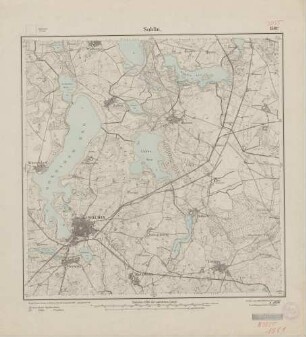
Agronomische Bohrungen. Section Soldin. Eingetragen in Meßtischblatt Nr. 1561 (preuß.) / 3055 (neu) Soldin
- Reference number
-
AKS 1720 A (1265824)
- Context
-
Allgemeine Kartensammlung >> Geologische und Hydrogeologische Karten >> Geologische Karten von Preußen >> Provinzen und Territorien
- Holding
-
AKS (112517) Allgemeine Kartensammlung
- Date of creation
-
1890-1901
- Last update
- 10.04.2026, 1:07 PM CEST
Data provider
This object is provided by:
Brandenburgisches Landeshauptarchiv.
If you have any questions about the object, please contact the data provider.
Object type
- Karte
Time of origin
- 1890-1901
Other Objects (12)
![[3055] Soldin Agronomische Bohrungen zu Blatt Soldin](https://iiif.deutsche-digitale-bibliothek.de/image/2/8f83ea06-dd13-434f-954b-b57caac47d78/full/!306,450/0/default.jpg)
[3055] Soldin Agronomische Bohrungen zu Blatt Soldin
![[3055] Soldin](https://iiif.deutsche-digitale-bibliothek.de/image/2/4600be79-36e7-4612-aecd-9e3bbe3ccdec/full/!306,450/0/default.jpg)
[3055] Soldin

Blatt 3055 Soldin
Blatt 1561 Soldin, neu: 3055
3055 (alte Nr.: 1561) Soldin
Blatt 1561 Soldin, neu: 3055
Blatt 1561 Soldin, neu: 3055
Blatt 1561 Soldin, neu: 3055
3055 (alte Nr.: 1561) Soldin, Meßtischblatt (4cm - Karte)
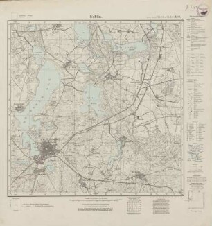
![Messtischblatt [3055] = 1561 : Soldin, 1927 : Messtischblatt [3055] = 1561 : Soldin. - Aufn. 1890, einz. Nachtr. 1927. - [Berlin] : Reichsamt für Landesaufnahme, 1927. - 1 Kt. : zweifarb.](https://iiif.deutsche-digitale-bibliothek.de/image/2/fee05954-105a-4890-822f-12563486d551/full/!306,450/0/default.jpg)
Messtischblatt [3055] = 1561 : Soldin, 1927 : Messtischblatt [3055] = 1561 : Soldin. - Aufn. 1890, einz. Nachtr. 1927. - [Berlin] : Reichsamt für Landesaufnahme, 1927. - 1 Kt. : zweifarb.
Soldin
Soldin
[3055] Soldin Agronomische Bohrungen zu Blatt Soldin
[3055] Soldin
Blatt 3055 Soldin
Blatt 1561 Soldin, neu: 3055
3055 (alte Nr.: 1561) Soldin
Blatt 1561 Soldin, neu: 3055
Blatt 1561 Soldin, neu: 3055
Blatt 1561 Soldin, neu: 3055
3055 (alte Nr.: 1561) Soldin, Meßtischblatt (4cm - Karte)
Messtischblatt [3055] = 1561 : Soldin, 1927 : Messtischblatt [3055] = 1561 : Soldin. - Aufn. 1890, einz. Nachtr. 1927. - [Berlin] : Reichsamt für Landesaufnahme, 1927. - 1 Kt. : zweifarb.
Soldin