Karte / Plan
Höhen- und Lageplan. Kilometer 19+600 bis Kilometer 20+400. | Westfälische Landeseisenbahn. Strecke Beckum-Ennigerloh-Warendorf. Gemeinde Warendorf. Blatt 3
- Reference number
-
S 07 Kartensammlung, 735
- Dimensions
-
148x68 cm
- Formal description
-
Handzeichnung; Die Betriebs-Direction, Lippstadt, gez. F. Schönfeld
- Material
-
Papier
- Notes
-
coloriert; kurze Blattränder ramponiert und teilweise stark verstaubt; rückseitiges Klebelabel: "Stadtarchiv Warendorf; Karten Nr. 16"
- Further information
-
Ort: Warendorf
Maßstab: 1:1000
- Context
-
Kartensammlung >> Karten und Pläne >> Verkehrspläne (Eisenbahn, Straßen und Wege, Kabel) >> Eisenbahnpläne
- Holding
-
S 07 Kartensammlung Kartensammlung
- Date of creation
-
1899
- Other object pages
- Delivered via
- Last update
- 05.11.2025, 3:35 PM CET
Data provider
This object is provided by:
Kreis Warendorf. Kreisarchiv, Kreisverwaltung. If you have any questions about the object, please contact the data provider.
Kreis Warendorf. Kreisarchiv, Kreisverwaltung. If you have any questions about the object, please contact the data provider.
Object type
- Karten und Pläne
Time of origin
- 1899
Other Objects (12)

Westfälische Landes-Eisenbahn. Strecke Beckum-Ennigerloh-Warendorf. Gemeinde Warendorf. Blatt 2. | Höhen- und Lageplan. Kilometer 18+650 bis Kilometer 19+600.
Westfälische Landes-Eisenbahn. Strecke Beckum-Ennigerloh-Warendorf. Gemeinde Warendorf. Blatt 3. | Höhen- und Lageplan. Kilometer 19+600 bis Kilometer 20+400.
Westfälische Landes-Eisenbahn. Strecke Beckum-Ennigerloh-Warendorf. Gemeinde Warendorf. Blatt 1. | Höhen- und Lageplan. Kilometer 17+550 bis Kilometer 18+850.

Kilometer 8+600, Zug fährt über Autobahn
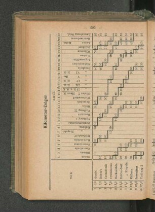
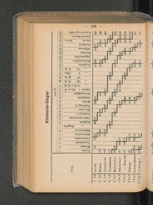
Kilometer-Zeiger
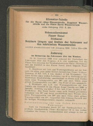
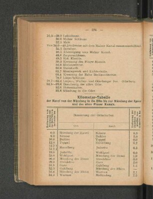
Kilometer-Tabelle
Zehntausend Kilometer
Zehntausend Kilometer
Kilometer-Tabelle
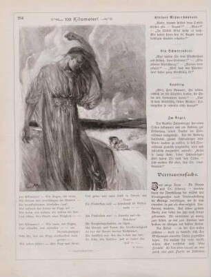
"100 Kilometer!"
Kilometer-Zeiger
Kilometer-Tabelle
Westfälische Landes-Eisenbahn. Strecke Beckum-Ennigerloh-Warendorf. Gemeinde Warendorf. Blatt 2. | Höhen- und Lageplan. Kilometer 18+650 bis Kilometer 19+600.
Westfälische Landes-Eisenbahn. Strecke Beckum-Ennigerloh-Warendorf. Gemeinde Warendorf. Blatt 3. | Höhen- und Lageplan. Kilometer 19+600 bis Kilometer 20+400.
Westfälische Landes-Eisenbahn. Strecke Beckum-Ennigerloh-Warendorf. Gemeinde Warendorf. Blatt 1. | Höhen- und Lageplan. Kilometer 17+550 bis Kilometer 18+850.
Kilometer 8+600, Zug fährt über Autobahn
Kilometer-Zeiger
Kilometer-Tabelle
Zehntausend Kilometer
Zehntausend Kilometer
Kilometer-Tabelle
"100 Kilometer!"
Kilometer-Zeiger