Topographische Karte
Topografische Karte der Roten Armee von einem Gebiet in Litauen
- Alternative title
-
Uprawlenije Wojennych topografow RKKA
N-35-13 (Krakinowo)
- Location
-
Deutsches Historisches Museum, Berlin
- Inventory number
-
Do 74/323I
- Measurements
-
Höhe x Breite: 39 x 55 cm
- Material/Technique
-
Papier, gedruckt
- Classification
-
Kartografie (Gattung)
- Subject (what)
-
Militär
Topographie
Litauen
- Event
-
Herstellung
- (who)
-
Herausgeber: Rote Armee
- (where)
-
Moskau ?, Land historisch: Sowjetunion
- (when)
-
1937
- Rights
-
Deutsches Historisches Museum
- Last update
- 24.03.2023, 9:30 AM CET
Data provider
This object is provided by:
Stiftung Deutsches Historisches Museum. If you have any questions about the object, please contact the data provider.
Stiftung Deutsches Historisches Museum. If you have any questions about the object, please contact the data provider.
Object type
- Topographische Karte
Associated
- Herausgeber: Rote Armee
Time of origin
- 1937
Other Objects (12)

Topografische Karte der Roten Armee von einem Gebiet in Weißrussland
Topografische Karte der Roten Armee von einem Gebiet in Weißrussland
Sowjetische Generalstabskarte eines Teiles von Litauen
Kriegszeitung der Roten Armee "Bojewaja Krasnoarmejskaja"
Kriegszeitung der Roten Armee "Bojewaja Krasnoarmejskaja"
Kriegszeitung der Roten Armee "Bojewaja Krasnoarmejskaja"
Ausweis für einen deutschen Angehörigen der Roten Armee
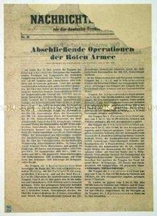
Sowjetisches Nachrichtenblatt zu den letzten Kampfhandlungen der Roten Armee in Europa
Propagandaflugblatt der Roten Armee mit der Garantie der Schonung bei der Gefangennahme
Propagandaflugblatt der Roten Armee mit der Garantie der Schonung bei der Gefangennahme
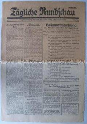
Tageszeitung der Roten Armee "Tägliche Rundschau" u.a. zur Bildung des Magistrats und über das Leben in der Sowjetunion
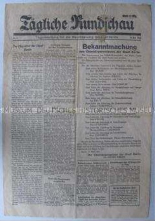
Tageszeitung der Roten Armee "Tägliche Rundschau" u.a. zur Bildung des Magistrats und über das Leben in der Sowjetunion
Topografische Karte der Roten Armee von einem Gebiet in Weißrussland
Topografische Karte der Roten Armee von einem Gebiet in Weißrussland
Sowjetische Generalstabskarte eines Teiles von Litauen
Kriegszeitung der Roten Armee "Bojewaja Krasnoarmejskaja"
Kriegszeitung der Roten Armee "Bojewaja Krasnoarmejskaja"
Kriegszeitung der Roten Armee "Bojewaja Krasnoarmejskaja"
Ausweis für einen deutschen Angehörigen der Roten Armee
Sowjetisches Nachrichtenblatt zu den letzten Kampfhandlungen der Roten Armee in Europa
Propagandaflugblatt der Roten Armee mit der Garantie der Schonung bei der Gefangennahme
Propagandaflugblatt der Roten Armee mit der Garantie der Schonung bei der Gefangennahme
Tageszeitung der Roten Armee "Tägliche Rundschau" u.a. zur Bildung des Magistrats und über das Leben in der Sowjetunion
Tageszeitung der Roten Armee "Tägliche Rundschau" u.a. zur Bildung des Magistrats und über das Leben in der Sowjetunion
Topografische Karte der Roten Armee von einem Gebiet in Weißrussland
Topografische Karte der Roten Armee von einem Gebiet in Weißrussland
Sowjetische Generalstabskarte eines Teiles von Litauen
Kriegszeitung der Roten Armee "Bojewaja Krasnoarmejskaja"
Kriegszeitung der Roten Armee "Bojewaja Krasnoarmejskaja"
Kriegszeitung der Roten Armee "Bojewaja Krasnoarmejskaja"
Ausweis für einen deutschen Angehörigen der Roten Armee
Sowjetisches Nachrichtenblatt zu den letzten Kampfhandlungen der Roten Armee in Europa
Propagandaflugblatt der Roten Armee mit der Garantie der Schonung bei der Gefangennahme
Propagandaflugblatt der Roten Armee mit der Garantie der Schonung bei der Gefangennahme
Tageszeitung der Roten Armee "Tägliche Rundschau" u.a. zur Bildung des Magistrats und über das Leben in der Sowjetunion