- Alternativer Titel
-
CARTE DES / INDES ORIENTALES / dessinée suivant les Observations les plus / recentes, dont le principal est tirée des
- Standort
-
Deutsches Historisches Museum, Berlin
- Inventarnummer
-
Do 2006/259.1-2
- Maße
-
Höhe x Breite: 57,3 x 66 cm (Blatt 1)
Höhe x Breite: 48,1 x 41,7 cm (Karte 1)
Höhe x Breite: 52,6 x 45,3 cm (Platte 1)
Höhe x Breite: 57 x 67 cm (Blatt 2)
Höhe x Breite: 48,3 x 41,9 cm (Karte 2)
Höhe x Breite: 53,2 x 45,7 cm (Platte 2)
- Material/Technik
-
Druckfarbe, Papier, Kupferstich, koloriert
- Klassifikation
-
Kartografie (Gattung)
- Bezug (was)
-
Asien
Südasien
Indien
Südostasien
- Ereignis
-
Herstellung
- (wer)
-
Kartograf: Johann Tobias Mayer
Stecher: Sebastian Dorn
Verlag: Homannsche Erben
- (wo)
-
Nürnberg, Deutschland
- (wann)
-
1748
- Rechteinformation
-
Deutsches Historisches Museum
- Letzte Aktualisierung
- 24.03.2023, 09:29 MEZ
Datenpartner
Dieses Objekt wird bereitgestellt von:
Stiftung Deutsches Historisches Museum. Bei Fragen zum Objekt wenden Sie sich bitte an den Datenpartner.
Stiftung Deutsches Historisches Museum. Bei Fragen zum Objekt wenden Sie sich bitte an den Datenpartner.
Objekttyp
- Seekarte
Beteiligte
- Kartograf: Johann Tobias Mayer
- Stecher: Sebastian Dorn
- Verlag: Homannsche Erben
Entstanden
- 1748
Ähnliche Objekte (12)

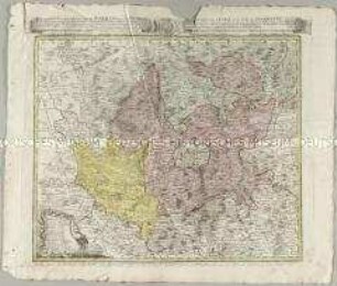
Carte du Diocese de Breslau
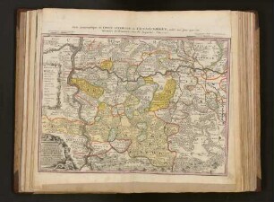
Carte geographique du Comté inferieur de Cazenelnbogen
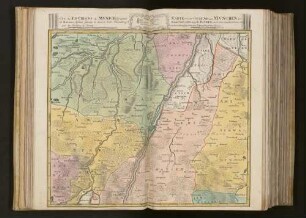
Carte des Environs de Munich la Capitale de Baviere
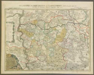
Carte geographique du Comté inferieur de Cazenelnbogen : mise au jour par les heritiers de Homann ; avec Pr. imperial
Atlas Regni Bohemiae: Repraesentatio Geographica Circuli Egerani, nec non Elnbogensis / Carte du Territoire d'Egra, & du Cercle d'Elnbogue
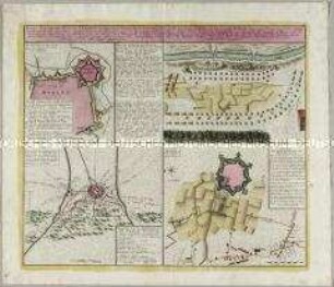
Kriegs-Expeditions-Karte in Italien A. 1742 u. 1743 zwischen der Oesterreichisch-Sardinischen und Spanischen Armee / Carte des Expeditions de Guerre en Italie l'An 1742 et 1743 entre les Autrichiens & leur Allié & entre les Espagnols
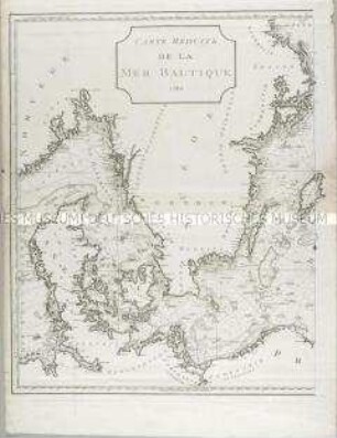
Carte réduite de la mer Baltique. Mit drei Nebenkarten: Carte du port de Dantzick; Carte du Sund; Plan de Gothenbourg
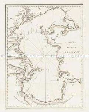
Carte de la Mer Caspienne
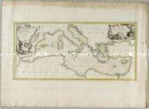
Carte de la Mer Méditerranée
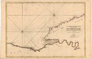
Carte Particulière des Costes de Normandie
![Karte von Kurkreis Sachsen später Wittenberger Kreis, 1:113 000, Kupferstich, 1752 : [Besondere Land-Karte des Herzogth. od. Churkreises Sachsen]Besondere Land Karte des Herzogth. od. Chvrkreises Sachsen : welcher aus den Aemtern Annaberg, Beltzig, Bitterfeld, Graefenhainchen, Liebenwerda, Pretsch, Seyda, Schlieben, Schweiniz, Daame, Iuterbock, Gommern u. Creis-Amt Witemberg zusammen gesezet ist ;nebst den Grafsch. Barby u. Baruth wie auch die Herrsch. Sonnewalde = Mappa Geographica exhibens Dvcatvm Saxoniae = Carte Géographique, ov on fait voir le Dvché de Saxonie nommé le Cercle Électorale / ans Licht gestellt von den Homaennischen Erben. - [Ca. 1:113 000]. - Norimb. : Homaennische Erben , 1752. - 1 Kt. auf 2 Bl. : kolor. Kupferst. ; Gesamtgr. 92 x 62 cm // Nullmeridian: Ferro. - NE oben. - Titel- und Erklärungskartusche unten links.- Parallelt. als Kopft. - Mit Kopft. für die Sektionen](https://iiif.deutsche-digitale-bibliothek.de/image/2/2202285f-e887-4faf-a9ff-08704d35ce07/full/!306,450/0/default.jpg)
Karte von Kurkreis Sachsen später Wittenberger Kreis, 1:113 000, Kupferstich, 1752 : [Besondere Land-Karte des Herzogth. od. Churkreises Sachsen]Besondere Land Karte des Herzogth. od. Chvrkreises Sachsen : welcher aus den Aemtern Annaberg, Beltzig, Bitterfeld, Graefenhainchen, Liebenwerda, Pretsch, Seyda, Schlieben, Schweiniz, Daame, Iuterbock, Gommern u. Creis-Amt Witemberg zusammen gesezet ist ;nebst den Grafsch. Barby u. Baruth wie auch die Herrsch. Sonnewalde = Mappa Geographica exhibens Dvcatvm Saxoniae = Carte Géographique, ov on fait voir le Dvché de Saxonie nommé le Cercle Électorale / ans Licht gestellt von den Homaennischen Erben. - [Ca. 1:113 000]. - Norimb. : Homaennische Erben , 1752. - 1 Kt. auf 2 Bl. : kolor. Kupferst. ; Gesamtgr. 92 x 62 cm // Nullmeridian: Ferro. - NE oben. - Titel- und Erklärungskartusche unten links.- Parallelt. als Kopft. - Mit Kopft. für die Sektionen
![Karte von Kurkreis Sachsen später Wittenberger Kreis, 1:113 000, Kupferstich, 1752 : [Besondere Land-Karte des Herzogth. od. Churkreises Sachsen]Besondere Land Karte des Herzogth. od. Chvrkreises Sachsen : welcher aus den Aemtern Annaberg, Beltzig, Bitterfeld, Graefenhainchen, Liebenwerda, Pretsch, Seyda, Schlieben, Schweiniz, Daame, Iuterbock, Gommern u. Creis-Amt Witemberg zusammen gesezet ist ;nebst den Grafsch. Barby u. Baruth wie auch die Herrsch. Sonnewalde = Mappa Geographica exhibens Dvcatvm Saxoniae = Carte Géographique, ov on fait voir le Dvché de Saxonie nommé le Cercle Électorale / ans Licht gestellt von den Homaennischen Erben. - [Ca. 1:113 000]. - Norimb. : Homaennische Erben , 1752. - 1 Kt. auf 2 Bl. : kolor. Kupferst. ; Gesamtgr. 92 x 62 cm // Nullmeridian: Ferro. - NE oben. - Titel- und Erklärungskartusche unten links.- Parallelt. als Kopft. - Mit Kopft. für die Sektionen](https://iiif.deutsche-digitale-bibliothek.de/image/2/5f3deea7-16c6-4318-b556-f0db346f361e/full/!306,450/0/default.jpg)
Karte von Kurkreis Sachsen später Wittenberger Kreis, 1:113 000, Kupferstich, 1752 : [Besondere Land-Karte des Herzogth. od. Churkreises Sachsen]Besondere Land Karte des Herzogth. od. Chvrkreises Sachsen : welcher aus den Aemtern Annaberg, Beltzig, Bitterfeld, Graefenhainchen, Liebenwerda, Pretsch, Seyda, Schlieben, Schweiniz, Daame, Iuterbock, Gommern u. Creis-Amt Witemberg zusammen gesezet ist ;nebst den Grafsch. Barby u. Baruth wie auch die Herrsch. Sonnewalde = Mappa Geographica exhibens Dvcatvm Saxoniae = Carte Géographique, ov on fait voir le Dvché de Saxonie nommé le Cercle Électorale / ans Licht gestellt von den Homaennischen Erben. - [Ca. 1:113 000]. - Norimb. : Homaennische Erben , 1752. - 1 Kt. auf 2 Bl. : kolor. Kupferst. ; Gesamtgr. 92 x 62 cm // Nullmeridian: Ferro. - NE oben. - Titel- und Erklärungskartusche unten links.- Parallelt. als Kopft. - Mit Kopft. für die Sektionen
Carte du Diocese de Breslau
Carte geographique du Comté inferieur de Cazenelnbogen
Carte des Environs de Munich la Capitale de Baviere
Carte geographique du Comté inferieur de Cazenelnbogen : mise au jour par les heritiers de Homann ; avec Pr. imperial
Atlas Regni Bohemiae: Repraesentatio Geographica Circuli Egerani, nec non Elnbogensis / Carte du Territoire d'Egra, & du Cercle d'Elnbogue
Kriegs-Expeditions-Karte in Italien A. 1742 u. 1743 zwischen der Oesterreichisch-Sardinischen und Spanischen Armee / Carte des Expeditions de Guerre en Italie l'An 1742 et 1743 entre les Autrichiens & leur Allié & entre les Espagnols
Carte réduite de la mer Baltique. Mit drei Nebenkarten: Carte du port de Dantzick; Carte du Sund; Plan de Gothenbourg
Carte de la Mer Caspienne
Carte de la Mer Méditerranée
Carte Particulière des Costes de Normandie
Karte von Kurkreis Sachsen später Wittenberger Kreis, 1:113 000, Kupferstich, 1752 : [Besondere Land-Karte des Herzogth. od. Churkreises Sachsen]Besondere Land Karte des Herzogth. od. Chvrkreises Sachsen : welcher aus den Aemtern Annaberg, Beltzig, Bitterfeld, Graefenhainchen, Liebenwerda, Pretsch, Seyda, Schlieben, Schweiniz, Daame, Iuterbock, Gommern u. Creis-Amt Witemberg zusammen gesezet ist ;nebst den Grafsch. Barby u. Baruth wie auch die Herrsch. Sonnewalde = Mappa Geographica exhibens Dvcatvm Saxoniae = Carte Géographique, ov on fait voir le Dvché de Saxonie nommé le Cercle Électorale / ans Licht gestellt von den Homaennischen Erben. - [Ca. 1:113 000]. - Norimb. : Homaennische Erben , 1752. - 1 Kt. auf 2 Bl. : kolor. Kupferst. ; Gesamtgr. 92 x 62 cm // Nullmeridian: Ferro. - NE oben. - Titel- und Erklärungskartusche unten links.- Parallelt. als Kopft. - Mit Kopft. für die Sektionen
Karte von Kurkreis Sachsen später Wittenberger Kreis, 1:113 000, Kupferstich, 1752 : [Besondere Land-Karte des Herzogth. od. Churkreises Sachsen]Besondere Land Karte des Herzogth. od. Chvrkreises Sachsen : welcher aus den Aemtern Annaberg, Beltzig, Bitterfeld, Graefenhainchen, Liebenwerda, Pretsch, Seyda, Schlieben, Schweiniz, Daame, Iuterbock, Gommern u. Creis-Amt Witemberg zusammen gesezet ist ;nebst den Grafsch. Barby u. Baruth wie auch die Herrsch. Sonnewalde = Mappa Geographica exhibens Dvcatvm Saxoniae = Carte Géographique, ov on fait voir le Dvché de Saxonie nommé le Cercle Électorale / ans Licht gestellt von den Homaennischen Erben. - [Ca. 1:113 000]. - Norimb. : Homaennische Erben , 1752. - 1 Kt. auf 2 Bl. : kolor. Kupferst. ; Gesamtgr. 92 x 62 cm // Nullmeridian: Ferro. - NE oben. - Titel- und Erklärungskartusche unten links.- Parallelt. als Kopft. - Mit Kopft. für die Sektionen
Carte du Diocese de Breslau
Carte geographique du Comté inferieur de Cazenelnbogen
Carte des Environs de Munich la Capitale de Baviere
Carte geographique du Comté inferieur de Cazenelnbogen : mise au jour par les heritiers de Homann ; avec Pr. imperial
Atlas Regni Bohemiae: Repraesentatio Geographica Circuli Egerani, nec non Elnbogensis / Carte du Territoire d'Egra, & du Cercle d'Elnbogue
Kriegs-Expeditions-Karte in Italien A. 1742 u. 1743 zwischen der Oesterreichisch-Sardinischen und Spanischen Armee / Carte des Expeditions de Guerre en Italie l'An 1742 et 1743 entre les Autrichiens & leur Allié & entre les Espagnols
Carte réduite de la mer Baltique. Mit drei Nebenkarten: Carte du port de Dantzick; Carte du Sund; Plan de Gothenbourg
Carte de la Mer Caspienne
Carte de la Mer Méditerranée
Carte Particulière des Costes de Normandie
Karte von Kurkreis Sachsen später Wittenberger Kreis, 1:113 000, Kupferstich, 1752 : [Besondere Land-Karte des Herzogth. od. Churkreises Sachsen]Besondere Land Karte des Herzogth. od. Chvrkreises Sachsen : welcher aus den Aemtern Annaberg, Beltzig, Bitterfeld, Graefenhainchen, Liebenwerda, Pretsch, Seyda, Schlieben, Schweiniz, Daame, Iuterbock, Gommern u. Creis-Amt Witemberg zusammen gesezet ist ;nebst den Grafsch. Barby u. Baruth wie auch die Herrsch. Sonnewalde = Mappa Geographica exhibens Dvcatvm Saxoniae = Carte Géographique, ov on fait voir le Dvché de Saxonie nommé le Cercle Électorale / ans Licht gestellt von den Homaennischen Erben. - [Ca. 1:113 000]. - Norimb. : Homaennische Erben , 1752. - 1 Kt. auf 2 Bl. : kolor. Kupferst. ; Gesamtgr. 92 x 62 cm // Nullmeridian: Ferro. - NE oben. - Titel- und Erklärungskartusche unten links.- Parallelt. als Kopft. - Mit Kopft. für die Sektionen