Karten und Pläne
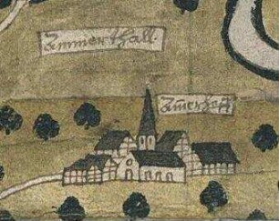
Tübingen. Grundriß zu Vorschlägen über die Ableitung der Ammer im Ammer-Thale
- Reference number
-
D 30/K 480
- Former reference number
-
prefix: D 30/K
- Dimensions
-
88,5 x 60 cm
- Formal description
-
N: Ammer / S: Nordwestliche Stadtmauer / W: Gewand Bei der Mauer / O: Nördliche Stadtmauer und Gärten nördlich der Ammer
- Material
-
Papier auf Leinwand
- Notes
-
Drei Profile
- Further information
-
Ausführung: Handzeichnung, koloriert
Maßstab: 50 württ. Ruten = 35,8 cm
Druck / Verlag: o.V
- Context
-
D 30 Karten- und Plansammlung >> Wasserbauwesen an Neckar, Ammer und Steinlach
- Holding
-
D 30 Karten- und Plansammlung
- Indexbegriff subject
-
Ammer, Ableitung
Ammertal
- Date of creation
-
1838
- Other object pages
- Last update
- 29.04.2025, 8:35 AM CEST
Data provider
This object is provided by:
Stadtarchiv Tübingen. If you have any questions about the object, please contact the data provider.
Stadtarchiv Tübingen. If you have any questions about the object, please contact the data provider.
Object type
- Karte und Plan
Time of origin
- 1838
Other Objects (12)

Sep. Ammern Ammern
Ammern (Tübingen - Herrenberg)
Ammer, Kurt. Ammer, Karin

Ammern

Ammern

Ammern
⟦Ammern⟧
Ammer
Ammer
Ammern
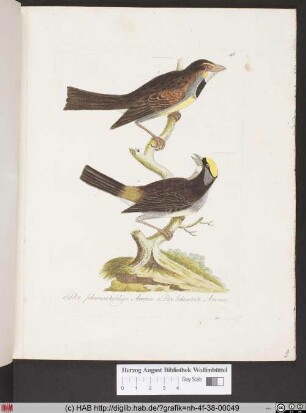
Der schwarzkehlige Ammer. Der bekraenzte Ammer.
Ammern: Besteuerung des Hofgutes zu Ammern
Sep. Ammern Ammern
Ammern (Tübingen - Herrenberg)
Ammer, Kurt. Ammer, Karin
Ammern
Ammern
Ammern
⟦Ammern⟧
Ammer
Ammer
Ammern
Der schwarzkehlige Ammer. Der bekraenzte Ammer.
Ammern: Besteuerung des Hofgutes zu Ammern
Sep. Ammern Ammern
Ammern (Tübingen - Herrenberg)
Ammer, Kurt. Ammer, Karin
Ammern
Ammern
Ammern
⟦Ammern⟧
Ammer
Ammer
Ammern
Der schwarzkehlige Ammer. Der bekraenzte Ammer.