Karten und Pläne
Bayern. Geographische Mauth-Karte von Bayern. Bemerkungen: 2 Exemplare
- Reference number
-
StAM, Kartensammlung 1763
- Former reference number
-
GH 991/14 GR 1639/66
- Dimensions
-
27 cm x 30,5 cm
- Formal description
-
Kupferstich
- Language of the material
-
deutsch
- Further information
-
Urheber: Zeichner: Johann Franz Kohlbrenner
Stecher: Tobias Conrad Lotter
- Context
-
Kartensammlung >> Kartensammlung >> 1. Kartensammlung Bd. 1-4 (retrokonvertiert)
- Holding
-
Kartensammlung
- Date of creation
-
1764
- Other object pages
- Last update
- 22.04.2025, 1:57 PM CEST
Data provider
This object is provided by:
Staatsarchiv München. If you have any questions about the object, please contact the data provider.
Staatsarchiv München. If you have any questions about the object, please contact the data provider.
Object type
- Karten und Pläne
Time of origin
- 1764
Other Objects (12)

Geographische Mauth-Charte von Bayern

Geographische Mauth-Charte von Bayern (ca. 1:700000)

Geographische Mauth-Charte von Bayern (ca. 1:700000)

10 Ausschnitt aus der Geographischen Mauth-Charte von Bayern

Die Mauth des Königreichs Bayern nach ihren Folgen beleuchtet

Die Mauth des Königsreichs Bayern nach ihren Folgen beleuchtet
"Geographische Mauth-Charte von Bayern vorstellend alle zu Wasser und zu Land hergebrachte Mauth-Stationen und Accis-Aemter samt denen dahin führenden Commercial- und Land-Strassen"
Mauth, Georg
Mauth, Betty
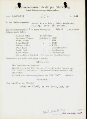
Mauth, Ernst
Mauth, Andreas
Mauth, Gottlob
Geographische Mauth-Charte von Bayern
Geographische Mauth-Charte von Bayern (ca. 1:700000)
Geographische Mauth-Charte von Bayern (ca. 1:700000)
10 Ausschnitt aus der Geographischen Mauth-Charte von Bayern
Die Mauth des Königreichs Bayern nach ihren Folgen beleuchtet
Die Mauth des Königsreichs Bayern nach ihren Folgen beleuchtet
"Geographische Mauth-Charte von Bayern vorstellend alle zu Wasser und zu Land hergebrachte Mauth-Stationen und Accis-Aemter samt denen dahin führenden Commercial- und Land-Strassen"
Mauth, Georg
Mauth, Betty
Mauth, Ernst
Mauth, Andreas