Akte
Geognostische Beschreibung der Gegend zwischen Katharinaberg (Hora Sv. Kateriny), Sebastiansberg (Hora Sv. Sebestiana), Komotau (Chomotov) und Brüx (Most)
Enthält u.a.: Vorkommen von Roteisenstein, Kalk, Braunkohle und Sandstein.
darin: : Bl. K 124: Petrographische Karte der Gegend von Brüx (Most), Katharinaberg (Hora Sv. Kateriny), Grünthal, Sebastiansberg (Hora Sv. Sebestiany), Komotau (Chomutov) und Görkau (Jirkov) - (60,0 cm x 88,0cm) - gesperrt, SL 982668 - Makrofiche 4457.
- Reference number
-
40003 Geognostische Gang- und Landesuntersuchungskommission, Nr. 100034 (Zu benutzen im Bergarchiv Freiberg)
- Former reference number
-
Registratursignatur: OBA-LU 135
- Context
-
40003 Geognostische Gang- und Landesuntersuchungskommission >> 1. Akten >> 1.2. Gebietsbeschreibungen
- Holding
-
40003 Geognostische Gang- und Landesuntersuchungskommission
- Date of creation
-
1827
- Other object pages
- Last update
- 10.12.2025, 3:22 PM CET
Data provider
This object is provided by:
Sächsisches Staatsarchiv. If you have any questions about the object, please contact the data provider.
Sächsisches Staatsarchiv. If you have any questions about the object, please contact the data provider.
Object type
- Akten
Time of origin
- 1827
Other Objects (12)
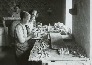
Kopfproduktion für Spielzeugfiguren, Papier, Hora Sv. Kateriny (Katharinaberg), Tschechien
![Niederseiffenbach, Seiffen, Heidelberg, Deutscheinsiedel, Deutschneudorf, Deutschkatharinenberg, Katharinaberg [Hora Sv. Kateriny], Rothenthal, Brandau [Brandov], Hirschberg](/assets/placeholder/searchResultMediaNoDigitisedMedia.png)
Niederseiffenbach, Seiffen, Heidelberg, Deutscheinsiedel, Deutschneudorf, Deutschkatharinenberg, Katharinaberg [Hora Sv. Kateriny], Rothenthal, Brandau [Brandov], Hirschberg
Katharinaberg [Hora Svaté Kateriny]; Bergstadt
Katharinaberg [Hora Svaté Kateriny]; Bergstadt

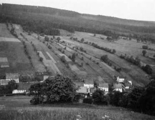
Sankt Katharinaberg (Hora Svaté Kateřiny). Ortsteilansicht
Katharinaberg [Hora Svaté Kateriny]; Nikolai Stollnmundloch
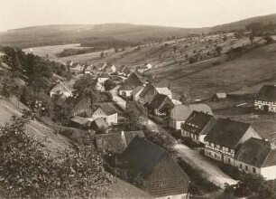
Ortsteilansicht : Katharinaberg (Hora Svate Kateriny/Tschechische Republik). Ortsteilansicht
Sankt Katharinaberg (heute Hora Svaté Kateřiny / Tschechien). Stadtansicht
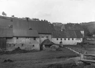
Katharinaberg [Hora Svaté Kateriny]; Wäsche der Nikolai Zeche

Sankt Katharinaberg (Hora Svaté Kateřiny). Ortsteilansicht (unterer Ortsteil)
![Kaiserzug Stolln bei Sebastiansberg [Hora Sv. Sebestiana] in Böhmen](https://iiif.deutsche-digitale-bibliothek.de/image/2/30239136-edff-47cc-bb53-ff0779e1d5fc/full/!306,450/0/default.jpg)
Kaiserzug Stolln bei Sebastiansberg [Hora Sv. Sebestiana] in Böhmen
Katharinaberg (Hora Svate Kateriny/CSSR). Nikolaizeche. Erzwäsche im Schweinitzbachtal
Kopfproduktion für Spielzeugfiguren, Papier, Hora Sv. Kateriny (Katharinaberg), Tschechien
Niederseiffenbach, Seiffen, Heidelberg, Deutscheinsiedel, Deutschneudorf, Deutschkatharinenberg, Katharinaberg [Hora Sv. Kateriny], Rothenthal, Brandau [Brandov], Hirschberg
Katharinaberg [Hora Svaté Kateriny]; Bergstadt
Katharinaberg [Hora Svaté Kateriny]; Bergstadt
Sankt Katharinaberg (Hora Svaté Kateřiny). Ortsteilansicht
Katharinaberg [Hora Svaté Kateriny]; Nikolai Stollnmundloch
Ortsteilansicht : Katharinaberg (Hora Svate Kateriny/Tschechische Republik). Ortsteilansicht
Sankt Katharinaberg (heute Hora Svaté Kateřiny / Tschechien). Stadtansicht
Katharinaberg [Hora Svaté Kateriny]; Wäsche der Nikolai Zeche
Sankt Katharinaberg (Hora Svaté Kateřiny). Ortsteilansicht (unterer Ortsteil)
Kaiserzug Stolln bei Sebastiansberg [Hora Sv. Sebestiana] in Böhmen