- Alternativer Titel
-
Neue / Topographische Karte / von / HAMBURG ALTONA und HARBURG
- Standort
-
Deutsches Historisches Museum, Berlin
- Inventarnummer
-
Do 2006/694
- Maße
-
Höhe x Breite: 50,6 x 61,5 cm (Blatt)
Höhe x Breite: 47,4 x 58,5 cm (Karte)
- Material/Technik
-
Papier, Lithographie, teilkoloriert
- Klassifikation
-
Kartografie (Gattung)
- Bezug (was)
-
Hamburg
- Ereignis
-
Herstellung
- (wer)
-
Kartograf: Ernst Franz Bernhardt
Stecher: Georg Heinrich Tischbein
- (wo)
-
Hamburg?, Deutschland
- (wann)
-
um 1815
- Rechteinformation
-
Deutsches Historisches Museum
- Letzte Aktualisierung
- 24.03.2023, 09:31 MEZ
Datenpartner
Dieses Objekt wird bereitgestellt von:
Stiftung Deutsches Historisches Museum. Bei Fragen zum Objekt wenden Sie sich bitte an den Datenpartner.
Stiftung Deutsches Historisches Museum. Bei Fragen zum Objekt wenden Sie sich bitte an den Datenpartner.
Objekttyp
- Belagerungskarte
Beteiligte
- Kartograf: Ernst Franz Bernhardt
- Stecher: Georg Heinrich Tischbein
Entstanden
- um 1815
Ähnliche Objekte (12)

Hafenarbeitsrecht für Hamburg, Altona, Harburg und Unterelbe
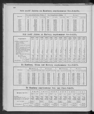
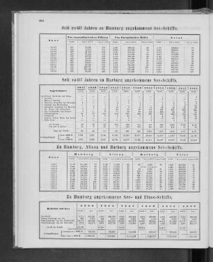
Zu Hamburg, Altona und Harburg angekommene See-Schiffe.

Zu Hamburg, Altona und Harburg angekommene See-Schiffe.

Zu Hamburg, Altona und Harburg angekommene See-Schiffe.
Zu Hamburg, Altona und Harburg angekommene See-Schiffe.

Zu Hamburg, Altona und Harburg angekommenne See-Schiffe.
Frachtsätze der Schleppschiffahrtslinie Harburg-Hamburg-Altona-Itzehoe-Stade

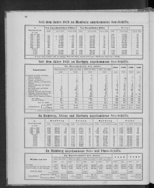
Zu Hamburg, Altona und Harburg angekommene See-Schiffe.

Zu Hamburg, Altona und Harburg angekommene See-Schiffe.
Zu Hamburg, Altona und Harburg angekommene See-Schiffe.
Zu Hamburg, Altona und Harburg angekommene See-Schiffe.
Zu Hamburg, Altona und Harburg angekommene See-Schiffe.
Hafenarbeitsrecht für Hamburg, Altona, Harburg und Unterelbe
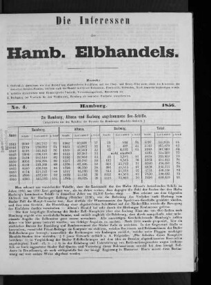
Zu Hamburg, Altona und Harburg angekommene See-Schiffe.
Zu Hamburg, Altona und Harburg angekommene See-Schiffe.
Zu Hamburg, Altona und Harburg angekommene See-Schiffe.
Zu Hamburg, Altona und Harburg angekommene See-Schiffe.
Zu Hamburg, Altona und Harburg angekommenne See-Schiffe.
Frachtsätze der Schleppschiffahrtslinie Harburg-Hamburg-Altona-Itzehoe-Stade
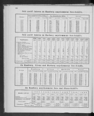
Zu Hamburg, Altona und Harburg angekommene See-Schiffe.
Zu Hamburg, Altona und Harburg angekommene See-Schiffe.
Zu Hamburg, Altona und Harburg angekommene See-Schiffe.
Zu Hamburg, Altona und Harburg angekommene See-Schiffe.
Zu Hamburg, Altona und Harburg angekommene See-Schiffe.
Hafenarbeitsrecht für Hamburg, Altona, Harburg und Unterelbe
Zu Hamburg, Altona und Harburg angekommene See-Schiffe.
Zu Hamburg, Altona und Harburg angekommene See-Schiffe.
Zu Hamburg, Altona und Harburg angekommene See-Schiffe.
Zu Hamburg, Altona und Harburg angekommene See-Schiffe.
Zu Hamburg, Altona und Harburg angekommenne See-Schiffe.
Frachtsätze der Schleppschiffahrtslinie Harburg-Hamburg-Altona-Itzehoe-Stade
Zu Hamburg, Altona und Harburg angekommene See-Schiffe.
Zu Hamburg, Altona und Harburg angekommene See-Schiffe.
Zu Hamburg, Altona und Harburg angekommene See-Schiffe.
Zu Hamburg, Altona und Harburg angekommene See-Schiffe.