
- Weitere Titel
-
Kriegs- und Gelegenheitskarten
- Standort
-
Forschungsbibliothek Gotha -- SPA 4° 00415 (09)
- Umfang
-
1 Kt, 60 x 43 cm
- Sprache
-
Deutsch
- Anmerkungen
-
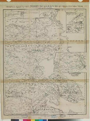
Nullmeridian: Ferro. - Maßstab in graph. Form (Deutsche Meilen, Seemeilen...). - Mit Bergstrichen. - Mit 3 Nebenkt.: [Belt] im Maßstab 1:1.800.000, [Ostsee] im Maßstab 1:3.700.000, St. Petersburg und Umgebungen Druck v. C. Hellfarth in Gotha Sammlung Perthes
- Beteiligte Personen und Organisationen
-
Forschungsbibliothek Gotha (Besitzer*in)
Berghaus, Hermann (Sonstige)
Perthes, Bernhardt (Sonstige)
Hellfarth, Carl (Sonstige)
Perthes, Justus (Sonstige)
- Erschienen
-
Gotha : Justus Perthes; Hellfarth , 1854
- URN
-
urn:nbn:de:urmel-637d22c8-c3e7-4496-b5ed-2d4946ba671e8-00011403-10
- PURL
- Letzte Aktualisierung
- 02.12.2025, 07:20 MEZ
Datenpartner
Dieses Objekt wird bereitgestellt von:
Forschungsbibliothek Gotha der Universität Erfurt. Bei Fragen zum Objekt wenden Sie sich bitte an den Datenpartner.
Forschungsbibliothek Gotha der Universität Erfurt. Bei Fragen zum Objekt wenden Sie sich bitte an den Datenpartner.
Objekttyp
- Karte
Beteiligte
- Forschungsbibliothek Gotha (Besitzer*in)
- Berghaus, Hermann (Sonstige)
- Perthes, Bernhardt (Sonstige)
- Hellfarth, Carl (Sonstige)
- Perthes, Justus (Sonstige)
Entstanden
- Gotha : Justus Perthes; Hellfarth , 1854
Ähnliche Objekte (12)

Übersichts-Karte von Mittel-Deutschland : östlicher Theil

Übersichts-Karte von Mittel-Deutschland : mittlerer Theil

Übersichts-Karte der westdeutschen Gränzlande
Special-Karte Von Nord-Schleswig

Die Insel Tristan da Cunha

Skizze des Distrikts von Kohat

Geognostische Übersichtskarte von Deutschland, der Schweiz und den angrenzenden Ländertheilen

1: Übersichts-Karte des Türkischen Reichs in Europa und Asien : mit Benutzung von F. v. Stülpnagel's "Europa & Orient"

Justus Perthes' Übersichtskarte vom nordöstlichen Frankreich bis Paris & c.

Kartenskizze über das Ergebniss der Reichstagswahlen am 10. Januar 1877 im Herzogthum S. Gotha
![[Carl Hellfarth Steindruckerei und Verlagsanstalt] : [Anzeige der Wohnungsänderung und Verlagsverzeichnis]](https://iiif.deutsche-digitale-bibliothek.de/image/2/f5496d5a-8e6a-4366-b1b3-f2a0e3e00431/full/!306,450/0/default.jpg)
[Carl Hellfarth Steindruckerei und Verlagsanstalt] : [Anzeige der Wohnungsänderung und Verlagsverzeichnis]

Wahlkarte über das Ergebniss der Reichstagswahlen am 30. Juli 1878 im Herzogthum S. Gotha
Übersichts-Karte von Mittel-Deutschland : östlicher Theil
Übersichts-Karte von Mittel-Deutschland : mittlerer Theil
Übersichts-Karte der westdeutschen Gränzlande
Special-Karte Von Nord-Schleswig
Die Insel Tristan da Cunha
Skizze des Distrikts von Kohat
Geognostische Übersichtskarte von Deutschland, der Schweiz und den angrenzenden Ländertheilen
1: Übersichts-Karte des Türkischen Reichs in Europa und Asien : mit Benutzung von F. v. Stülpnagel's "Europa & Orient"
Justus Perthes' Übersichtskarte vom nordöstlichen Frankreich bis Paris & c.
Kartenskizze über das Ergebniss der Reichstagswahlen am 10. Januar 1877 im Herzogthum S. Gotha
[Carl Hellfarth Steindruckerei und Verlagsanstalt] : [Anzeige der Wohnungsänderung und Verlagsverzeichnis]