- Alternative title
-
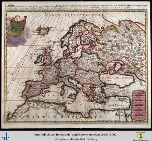
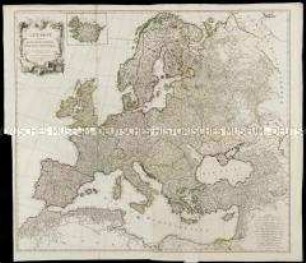
L'EUROPA / DIVISÉE EN / TOUTTES RÉGIONS / ET GRANDS ESTATS.
- Location
-
Deutsches Historisches Museum, Berlin
- Inventory number
-
Do 2006/1001
- Measurements
-
Höhe x Breite: 58 x 79,5 cm (Blatt)
Höhe x Breite: 45,5 x 50,7 cm (Karte)
Höhe x Breite: 49 x 66,3 cm (Platte)
- Material/Technique
-
Papier, Kupferstich, grenzkoloriert
- Classification
-
Kartografie (Gattung)
- Subject (what)
-
Europa
- Event
-
Herstellung
- (who)
-
Geograph, Stecher, Verleger: Jean Baptiste Nolin (1686)?
Geograph, Stecher: Louis Denis
Stecher: Paul-André Basset?
- (where)
-
Paris, Frankreich
- (when)
-
1785
- Rights
-
Deutsches Historisches Museum
- Last update
- 24.03.2023, 9:29 AM CET
Data provider
This object is provided by:
Stiftung Deutsches Historisches Museum. If you have any questions about the object, please contact the data provider.
Stiftung Deutsches Historisches Museum. If you have any questions about the object, please contact the data provider.
Object type
- Kontinentalkarte
Associated
- Geograph, Stecher, Verleger: Jean Baptiste Nolin (1686)?
- Geograph, Stecher: Louis Denis
- Stecher: Paul-André Basset?
Time of origin
- 1785
Other Objects (12)
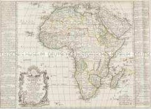
Afrique divisée en ses grandes Régions et subdivisée en ses grands Estats
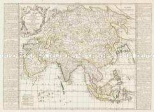
L'Asie divisée en ses grandes Régions et Empires subdivisée en ses Principaux Estats
LEurope divisée suivant l'estendue de ses principaux estats subdivisés en leurs principales provinces

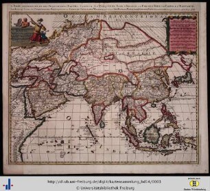
L'Asie Divisée en ses Empires, Royaumes, et Estats
L' Asie, divisée en ses Principales Regions...
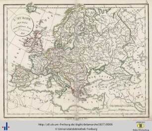
L'Europe divisée en ses différens États. 1826.

L'Europe divisée en ses Empires, Royaumes et Republiques
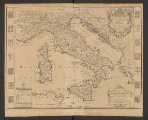
L'Italie Divisee En Ses Estats : Dressée et Dediée A Monseigneur Le Dauphin

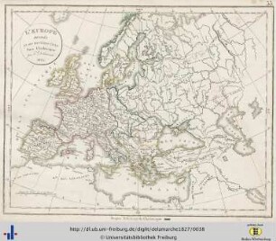
L'Europe : divisée en ses états, empires, royaumes et républiques
L'Europe divisée en ses différens états sous Charlemagne. 1825.
L'Europe divisée en ses Etats, Empires, Royaumes et Republiques

L'Europe : divisée en tous ses Royaumes et subdivisée en ses principales parties
Afrique divisée en ses grandes Régions et subdivisée en ses grands Estats
L'Asie divisée en ses grandes Régions et Empires subdivisée en ses Principaux Estats
LEurope divisée suivant l'estendue de ses principaux estats subdivisés en leurs principales provinces
L'Asie Divisée en ses Empires, Royaumes, et Estats
L' Asie, divisée en ses Principales Regions...
L'Europe divisée en ses différens États. 1826.
L'Europe divisée en ses Empires, Royaumes et Republiques
L'Italie Divisee En Ses Estats : Dressée et Dediée A Monseigneur Le Dauphin
L'Europe : divisée en ses états, empires, royaumes et républiques
L'Europe divisée en ses différens états sous Charlemagne. 1825.
L'Europe divisée en ses Etats, Empires, Royaumes et Republiques