- Alternativer Titel
-
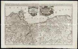
DAS MARGGRAF= UND CHURFURSTENTHUM / BRANDENBURG / Wie es ist ein Theil des Obersaechsischen Kreÿsses. / Vorgestellt durch S. SANSON des Königs
- Standort
-
Deutsches Historisches Museum, Berlin
- Inventarnummer
-
Do 2006/501
- Maße
-
Höhe x Breite: 65,5 x 97,3 cm (Blatt)
Höhe x Breite: 51,6 x 86,2 cm (Karte)
Höhe x Breite: 56,7 x 88,8 cm (Platte)
- Material/Technik
-
Papier, Kupferstich
- Klassifikation
-
Kartografie (Gattung)
- Bezug (was)
-
Brandenburg
- Ereignis
-
Herstellung
- (wer)
-
Verleger: Johann Hoffmann
Stecher: Sigmund Gabriel Hipschmann
Geograph, Kartograf: Guillaume Sanson
- (wo)
-
Nürnberg, Deutschland
- (wann)
-
um 1675
- Rechteinformation
-
Deutsches Historisches Museum
- Letzte Aktualisierung
- 24.03.2023, 08:30 UTC
Datenpartner
Dieses Objekt wird bereitgestellt von:
Stiftung Deutsches Historisches Museum. Bei Fragen zum Objekt wenden Sie sich bitte an den Datenpartner.
Stiftung Deutsches Historisches Museum. Bei Fragen zum Objekt wenden Sie sich bitte an den Datenpartner.
Objekttyp
- Regionalkarte
Beteiligte
- Verleger: Johann Hoffmann
- Stecher: Sigmund Gabriel Hipschmann
- Geograph, Kartograf: Guillaume Sanson
Entstanden
- um 1675
Ähnliche Objekte (12)
Das Hertzogthum Pommern
Das heyl. Römische Reich Teutscher Nation Worinnen begriffen desselben Chur- und Fürstenthümber, auch Länder sampt einen Theil von desselben angrentzenden Königreichen und Provinzien
Grundrichtiger Entwurff des gantzen Franckenlandes / Totius Franconiae accurata descriptio
Circulus Franconiae
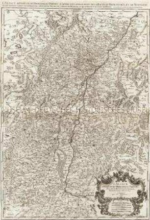
L'Alsace divisée en ses principales Parties.

Abbildung eines von Gott und Menschen geliebten ... Schul-Jünglings

Konzessionsgesuch und Verehelichungsgesuch des Nagelschmiedgesellen Johann Hoffmann von Pleofen nach Thurnau
Heimat des in Pressath verstorbenen Johann Hoffmann aus Weihersberg (Bezahlung von Verpflegung und Leichenkosten)

Vogelschaukarte von Wien, Radierung, 1683 : Wahre und Eigentliche Abbildung, der, dieser Zeit, vom dem Türckischen Mord-Saibel, höchst geängstigten...Hertz- Haupt- und Kayserl. Residenz-Stadt Wien, in Oesterreich : Was sich mit selbiger...Denkwürdiges begeben, in einem kurtzen Kern, verabfasset und vorgestellt. - Nürnberg : Johann Hoffmann , 1683. - 1 Vogelschaukt. : Radierung ; 27 x 15 cm S oben. - Kopft. - Ohne Kt.-Netz. - Windrose unten rechts. - Mit Gebäudekennzeichn. - Text außerhalb der Druckplatte im Hochdruck

Kurtze Relation und Entwurff, der Röm: Käyserl. Mayest: LEOPOLDI, Zu Nürnberg gehaltenen Einzugs, geschehen den 6. (16.) Augusti. Im Jahr Christi. 1658.

Trauer- Trost- und DanckRede bey dem ... LeichenBegängniß Der ... Anna Marien Schultzin/ gebohrne Schmeltzerin/ Des ... Gottfried Günther Schultzens ... Diaconi allhier EheLiebsten
![Leopold-Wilhelm Marggrav von Baden und Hochberg [et]c. [et]c. Deß heilige Rom. Reichs Armeen Ober Feld Herr wider den Türcken / Joh. Hoffman Ex.](https://iiif.deutsche-digitale-bibliothek.de/image/2/db2783cc-d905-481a-9770-89bd1b078e60/full/!306,450/0/default.jpg)
Leopold-Wilhelm Marggrav von Baden und Hochberg [et]c. [et]c. Deß heilige Rom. Reichs Armeen Ober Feld Herr wider den Türcken / Joh. Hoffman Ex.
Das Hertzogthum Pommern
Das heyl. Römische Reich Teutscher Nation Worinnen begriffen desselben Chur- und Fürstenthümber, auch Länder sampt einen Theil von desselben angrentzenden Königreichen und Provinzien
Grundrichtiger Entwurff des gantzen Franckenlandes / Totius Franconiae accurata descriptio
Circulus Franconiae
L'Alsace divisée en ses principales Parties.
Abbildung eines von Gott und Menschen geliebten ... Schul-Jünglings
Konzessionsgesuch und Verehelichungsgesuch des Nagelschmiedgesellen Johann Hoffmann von Pleofen nach Thurnau
Heimat des in Pressath verstorbenen Johann Hoffmann aus Weihersberg (Bezahlung von Verpflegung und Leichenkosten)
Vogelschaukarte von Wien, Radierung, 1683 : Wahre und Eigentliche Abbildung, der, dieser Zeit, vom dem Türckischen Mord-Saibel, höchst geängstigten...Hertz- Haupt- und Kayserl. Residenz-Stadt Wien, in Oesterreich : Was sich mit selbiger...Denkwürdiges begeben, in einem kurtzen Kern, verabfasset und vorgestellt. - Nürnberg : Johann Hoffmann , 1683. - 1 Vogelschaukt. : Radierung ; 27 x 15 cm S oben. - Kopft. - Ohne Kt.-Netz. - Windrose unten rechts. - Mit Gebäudekennzeichn. - Text außerhalb der Druckplatte im Hochdruck
Kurtze Relation und Entwurff, der Röm: Käyserl. Mayest: LEOPOLDI, Zu Nürnberg gehaltenen Einzugs, geschehen den 6. (16.) Augusti. Im Jahr Christi. 1658.
Trauer- Trost- und DanckRede bey dem ... LeichenBegängniß Der ... Anna Marien Schultzin/ gebohrne Schmeltzerin/ Des ... Gottfried Günther Schultzens ... Diaconi allhier EheLiebsten