Abschnitt | Altkarte | map
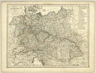
Germany (Deutschland) II : Eastern Part Of The Prussian States.

- Weitere Titel
-
Maps of the Society for the Diffusion of Useful Knowledge
- Umfang
-
1 Karte
- Sprache
-
Englisch
- Anmerkungen
-
Published under the Superintendence of the Society for the Diffusion of Useful Knowledge. ; J. & C. Walker Sculpt.
- Beteiligte Personen und Organisationen
- Erschienen
-
London ; [London] : Published by Baldwin & Cradock ; Printed by E. Brain , 1832
- Geliefert über
- URN
-
urn:nbn:de:0128-2-4795
- Letzte Aktualisierung
- 12.03.2025, 16:30 MEZ
Datenpartner
Dieses Objekt wird bereitgestellt von:
Universität Trier. Universitätsbibliothek.
Bei Fragen zum Objekt wenden Sie sich bitte an den Datenpartner.
Objekttyp
- map ; Altkarte ; Abschnitt
Entstanden
- London ; [London] : Published by Baldwin & Cradock ; Printed by E. Brain , 1832
Ähnliche Objekte (12)

Germany (Deutschland) I : Holstein, Hanover, Mecklenburg, The Prussian States, Saxony &c.
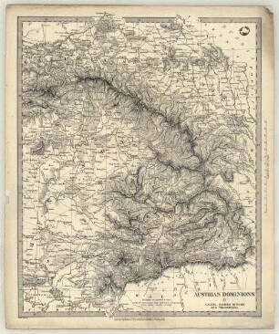
Austrian Dominions II : Galizia, Eastern Hungary And Transylvania.
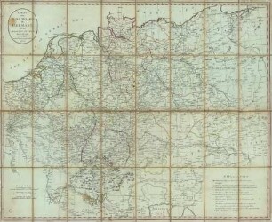
A Map of the Post Roads of Germany and the Adjacent States
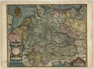
Germaniae Typvs. : Magnifico, Nobili, ac Præcellentj viro ac Domino, D. Constantino a Lyskirchen, florentissimæ Agrippinensis Reipub. Consuli Seniori, Franciscus Hogenbergius nuncupat. : Cum Gratia et Priuilegio
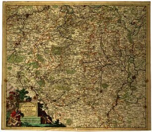
Ducatus Lutzenburgi Nova et Accurata Tabula cum Adjacentibus Provinciis et Omnibus Suis Regionibus Delineatio : cum Privil: Ord: Holland: et WestFriesiæ
Allemagne
![Nancy : Capitale in Lottringen nahme Carl Hertzog ṽ Lottringen 1475. Renat[us] eroberte es 1476. Carl aber belagerte es wiederumb 1477, undt verlohre dafur sein leben, ũ die Schlacht 1587 wurdte es fortificiert, 1631 ṽ den frantzosen eingenomen, 1661 demoliert und hernach repariert worden](https://iiif.deutsche-digitale-bibliothek.de/image/2/721f8391-c24b-449b-94df-bf27437d54f1/full/!306,450/0/default.jpg)
Nancy : Capitale in Lottringen nahme Carl Hertzog ṽ Lottringen 1475. Renat[us] eroberte es 1476. Carl aber belagerte es wiederumb 1477, undt verlohre dafur sein leben, ũ die Schlacht 1587 wurdte es fortificiert, 1631 ṽ den frantzosen eingenomen, 1661 demoliert und hernach repariert worden

Tabula Geographica Imperii Germanici per novissimas observationes emendata jussuque Academ. Regiae Scient. et Eleg. Litt. Bor. descripta in qua simul Stationes Cursuum et Veredariorum Publicorum exhibentur a I.C.R. : Cum Privilegio

A Generall Mapp Of The Empire Of Germany. : with its severall Estates. : To ye Rt. Hon John Egerton Earl of Bridgewater Vist: Brackles Bart. of Elsmere Ld:Leiutenant Buckingham Shire & one if Ld: of his Matys most Hon Privy Councell &c. This Mapp is Humbly Dedicated by R B
![Carta Noua accurata del Paßagio et strada dalli Paesi Baßi per via de Allemagna per Italia et per via di Paesi Suizeri à Geneua, Lione et Roma per Seruizio delli Marchanti et viagianti in Gen[er]ale ad instanza delli Ss̃: scherer et di Momforti Speditori delli Marchantie in Bregens, dato in luce da Cornelio Dancherts di Amsterdam l'anno 1651.](https://iiif.deutsche-digitale-bibliothek.de/image/2/74dae1a1-7d62-41ea-a953-c8cfaeb6e067/full/!306,450/0/default.jpg)
Carta Noua accurata del Paßagio et strada dalli Paesi Baßi per via de Allemagna per Italia et per via di Paesi Suizeri à Geneua, Lione et Roma per Seruizio delli Marchanti et viagianti in Gen[er]ale ad instanza delli Ss̃: scherer et di Momforti Speditori delli Marchantie in Bregens, dato in luce da Cornelio Dancherts di Amsterdam l'anno 1651.
![Generalis Exactissima Et Novissima Germaniæ Descriptio Et In Ea Eivs Regna, Principatvs, Dvcatvs, Dynastiæ, Et Alia Dominat[us], Vsqve In Hodiernvm, Per Melchiorem Tavernier, Calcographvm Regivm, Parisiis In Insvla Palatii Svb Insignio Sphæræ Ao. 1638.](https://iiif.deutsche-digitale-bibliothek.de/image/2/0d5e6bf0-cc88-4b3d-8853-72282e4ba25c/full/!306,450/0/default.jpg)
Generalis Exactissima Et Novissima Germaniæ Descriptio Et In Ea Eivs Regna, Principatvs, Dvcatvs, Dynastiæ, Et Alia Dominat[us], Vsqve In Hodiernvm, Per Melchiorem Tavernier, Calcographvm Regivm, Parisiis In Insvla Palatii Svb Insignio Sphæræ Ao. 1638.

Das Herzogthum Ober und Nieder Baiern in seine Aemter oder Gerichter eingetheilt, nebst allen darinn liegenden und angrænzenden Lændern
Germany (Deutschland) I : Holstein, Hanover, Mecklenburg, The Prussian States, Saxony &c.
Austrian Dominions II : Galizia, Eastern Hungary And Transylvania.
A Map of the Post Roads of Germany and the Adjacent States
Germaniae Typvs. : Magnifico, Nobili, ac Præcellentj viro ac Domino, D. Constantino a Lyskirchen, florentissimæ Agrippinensis Reipub. Consuli Seniori, Franciscus Hogenbergius nuncupat. : Cum Gratia et Priuilegio
Ducatus Lutzenburgi Nova et Accurata Tabula cum Adjacentibus Provinciis et Omnibus Suis Regionibus Delineatio : cum Privil: Ord: Holland: et WestFriesiæ
Allemagne
Nancy : Capitale in Lottringen nahme Carl Hertzog ṽ Lottringen 1475. Renat[us] eroberte es 1476. Carl aber belagerte es wiederumb 1477, undt verlohre dafur sein leben, ũ die Schlacht 1587 wurdte es fortificiert, 1631 ṽ den frantzosen eingenomen, 1661 demoliert und hernach repariert worden
Tabula Geographica Imperii Germanici per novissimas observationes emendata jussuque Academ. Regiae Scient. et Eleg. Litt. Bor. descripta in qua simul Stationes Cursuum et Veredariorum Publicorum exhibentur a I.C.R. : Cum Privilegio
A Generall Mapp Of The Empire Of Germany. : with its severall Estates. : To ye Rt. Hon John Egerton Earl of Bridgewater Vist: Brackles Bart. of Elsmere Ld:Leiutenant Buckingham Shire & one if Ld: of his Matys most Hon Privy Councell &c. This Mapp is Humbly Dedicated by R B
Carta Noua accurata del Paßagio et strada dalli Paesi Baßi per via de Allemagna per Italia et per via di Paesi Suizeri à Geneua, Lione et Roma per Seruizio delli Marchanti et viagianti in Gen[er]ale ad instanza delli Ss̃: scherer et di Momforti Speditori delli Marchantie in Bregens, dato in luce da Cornelio Dancherts di Amsterdam l'anno 1651.
Generalis Exactissima Et Novissima Germaniæ Descriptio Et In Ea Eivs Regna, Principatvs, Dvcatvs, Dynastiæ, Et Alia Dominat[us], Vsqve In Hodiernvm, Per Melchiorem Tavernier, Calcographvm Regivm, Parisiis In Insvla Palatii Svb Insignio Sphæræ Ao. 1638.