- Alternative title
-
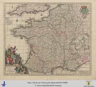
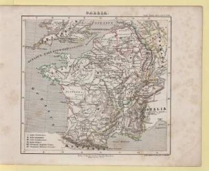
GALLIA ANTIQUA / EX AEVI ROMANI MONUMENTIS / ERUTA / ET SER.MICARNUTUM DUCIS
- Location
-
Deutsches Historisches Museum, Berlin
- Inventory number
-
Do 2006/911
- Measurements
-
Höhe x Breite: 55 x 79 cm (Blatt)
Höhe x Breite: 45,3 x 55,3 cm (Karte)
Höhe x Breite: 48,5 x 57,5 cm (Platte)
- Material/Technique
-
Papier, Kupferstich, grenzkoloriert
- Classification
-
Kartografie (Gattung)
- Subject (what)
-
Frankreich
Gallien
- Event
-
Herstellung
- (who)
-
Geograph, Kartograf: Jean Baptiste Bourguignon d' Anville
Verleger, Kartograf: Francesco Santini
Kartograpg, Verleger: Giuseppe Antonio Remondini
- (where)
-
Venedig, Italien
- (when)
-
um 1760
- Rights
-
Deutsches Historisches Museum
- Last update
-
24.03.2023, 9:29 AM CET
Data provider
This object is provided by:
Stiftung Deutsches Historisches Museum. If you have any questions about the object, please contact the data provider.
Stiftung Deutsches Historisches Museum. If you have any questions about the object, please contact the data provider.
Object type
- Volksgeschichtliche Karte
Associated
- Geograph, Kartograf: Jean Baptiste Bourguignon d' Anville
- Verleger, Kartograf: Francesco Santini
- Kartograpg, Verleger: Giuseppe Antonio Remondini
Time of origin
- um 1760
Other Objects (12)

Gallia antiqua
III Gallia Antiqua

Caput II. De Gallia Antiqua Transalpina.
Gallia
Gallia
Gallia.
Gallia
Gallia
Gallia
Gallia

Gallia
Gallia
Gallia antiqua
III Gallia Antiqua
Caput II. De Gallia Antiqua Transalpina.
Gallia
Gallia
Gallia.
Gallia
Gallia
Gallia
Gallia
Gallia
Gallia
Gallia antiqua
III Gallia Antiqua
Caput II. De Gallia Antiqua Transalpina.
Gallia
Gallia
Gallia.
Gallia
Gallia
Gallia
Gallia
Gallia