Archivale
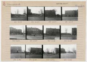
Treptower Spree in Km 25,1 - 26,7. Lageplan Gemarkung Köllnische Heide - Köpenick
- Reference number
-
57 WSD K 2750 C
- Context
-
Rep. 57 Wasserstraßendirektion Potsdam - Karten >> Wasserstraßenamt Köpenick >> Vermessungs- und Kartenwesen >> Spree-Oder-Wasserstraße >> Treptower Spree
- Holding
-
57 WSD K (15603) Rep. 57 Wasserstraßendirektion Potsdam - Karten
- Other object pages
- Last update
-
07.04.2025, 11:32 AM CEST
Data provider
This object is provided by:
Brandenburgisches Landeshauptarchiv. If you have any questions about the object, please contact the data provider.
Brandenburgisches Landeshauptarchiv. If you have any questions about the object, please contact the data provider.
Object type
- Archivale
Other Objects (12)

Treptower Spree in Km 25,1 - 26,7. Lageplan Gemarkung Köllnische Heide und Treptower Park
Spree-Oder-Wasserstraßen in Km 25,05 - 25,6. Treptower Spree. Gemarkung Köllnische Heide - Köpenick
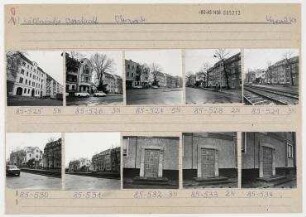
Stadtbezik Berlin-Köpenick Köllnische Vorstadt
[Verbindungsbahn Köpenick bis Köllnische Heide]
Standortgenehmigung 4918 - Köllnische Vorstadt (Köpenick)
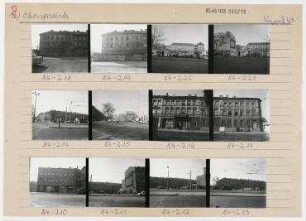
Straßenansichten. Berlin, Köpenick, Köllnische Vorstadt, Oberspreestraße
Straßenansichten. Berlin, Köpenick, Köllnische Vorstadt, Oberspreestraße
Straßenansichten. Berlin, Köpenick, Köllnische Vorstadt, Oberspreestraße
Bahnstrecke Neukölln-Baumschulenweg (Köllnische Heide - Köpenick)

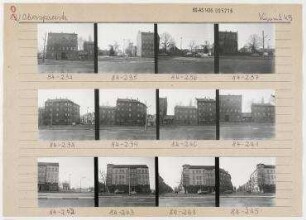
Straßenansichten. Berlin, Köpenick, Köllnische Vorstadt, Oberspreestraße
Straßenansichten. Berlin, Köpenick, Köllnische Vorstadt, Oberspreestraße
Straßenansichten. Berlin, Köpenick, Köllnische Vorstadt, Oberspreestraße
Treptower Spree in Km 25,1 - 26,7. Lageplan Gemarkung Köllnische Heide und Treptower Park
Spree-Oder-Wasserstraßen in Km 25,05 - 25,6. Treptower Spree. Gemarkung Köllnische Heide - Köpenick
Stadtbezik Berlin-Köpenick Köllnische Vorstadt
[Verbindungsbahn Köpenick bis Köllnische Heide]
Standortgenehmigung 4918 - Köllnische Vorstadt (Köpenick)
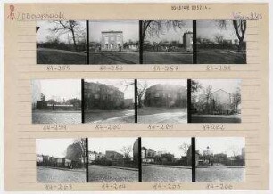
Straßenansichten. Berlin, Köpenick, Köllnische Vorstadt, Oberspreestraße
Straßenansichten. Berlin, Köpenick, Köllnische Vorstadt, Oberspreestraße
Straßenansichten. Berlin, Köpenick, Köllnische Vorstadt, Oberspreestraße
Bahnstrecke Neukölln-Baumschulenweg (Köllnische Heide - Köpenick)
Straßenansichten. Berlin, Köpenick, Köllnische Vorstadt, Oberspreestraße
Straßenansichten. Berlin, Köpenick, Köllnische Vorstadt, Oberspreestraße
Straßenansichten. Berlin, Köpenick, Köllnische Vorstadt, Oberspreestraße
Treptower Spree in Km 25,1 - 26,7. Lageplan Gemarkung Köllnische Heide und Treptower Park
Spree-Oder-Wasserstraßen in Km 25,05 - 25,6. Treptower Spree. Gemarkung Köllnische Heide - Köpenick
Stadtbezik Berlin-Köpenick Köllnische Vorstadt
[Verbindungsbahn Köpenick bis Köllnische Heide]
Standortgenehmigung 4918 - Köllnische Vorstadt (Köpenick)
Straßenansichten. Berlin, Köpenick, Köllnische Vorstadt, Oberspreestraße
Straßenansichten. Berlin, Köpenick, Köllnische Vorstadt, Oberspreestraße
Straßenansichten. Berlin, Köpenick, Köllnische Vorstadt, Oberspreestraße
Bahnstrecke Neukölln-Baumschulenweg (Köllnische Heide - Köpenick)
Straßenansichten. Berlin, Köpenick, Köllnische Vorstadt, Oberspreestraße
Straßenansichten. Berlin, Köpenick, Köllnische Vorstadt, Oberspreestraße