Verzeichnung
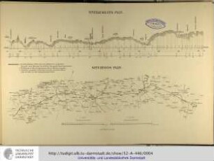
"Situations- und Nivellementsplan des Else-Flusses und der Umflut vor der Mühle zu Melle". Vergl. Nr. 6 Ausf.-Art: Farbige Zeichnung Herst.: Winter Format: 37 x 66 cm Maßstab: 1 : 80 bzw. 2000
- Reference number
-
NLA OS, K, 42 Melle Nr. 5 H
- Former reference number
-
Rep 200 Nr. 2586
- Further information
-
Ergänzungen: Klassifikation TeilB: melle
- Context
-
Karten >> 5 Regierungsbezirk Weser-Ems >> 5.13 Landkreis Osnabrück >> 5.13.5 Feldmarken, Stadt- und Ortspläne, Flurstücke >> 5.13.5.18 Stadt Melle
- Holding
-
NLA OS, K Karten
- Indexentry person
-
Winter
- Indexentry place
-
Melle, Else-Fluss, Umflut, Mühle
- Date of creation
-
- 1876
- Other object pages
- Last update
-
16.06.2025, 11:09 AM CEST
Data provider
This object is provided by:
Niedersächsisches Landesarchiv. If you have any questions about the object, please contact the data provider.
Niedersächsisches Landesarchiv. If you have any questions about the object, please contact the data provider.
Object type
- Verzeichnung
Time of origin
- - 1876
Other Objects (12)
Nivellements-Plan / Situations-Plan

Situations- und Nivellementsplan der Müllroser Bahnhofschaussee
Situations- und Nivellementsplan der Dorflage Meinsdorf
Situations- und Nivellementsplan des Dorfes Niesen
Leipzig - Dresdner Eisenbahn. Situations- und Nivellementsplan
Situations- und Nivellementsplan des oberen Landgrabens
Situations- und Nivellementsplan des Havelländischen Hauptkanals
![[Situations- und Nivellementsplan eines unbekannten Wasserlaufs].](https://iiif.deutsche-digitale-bibliothek.de/image/2/93322303-2708-4f5a-bd99-8326b1e0f4d3/full/!306,450/0/default.jpg)
[Situations- und Nivellementsplan eines unbekannten Wasserlaufs].

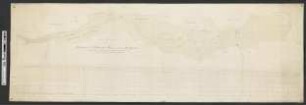
"Situations- und Nivellementsplan von dem Else-Fluss und der Umflut vor der Mühle zu Melle". östlich der Straße von Melle zum Bahnof. Blatt- und Pazellenzahlen der Gemarkungskarte. Vergl. Nr. 5 Ausf.-Art: Farbige Zeichnung Herst.: Winter Format: 40 x 128 cm Maßstab: 1 : 80 bzw. 2000
Situations- und Nivellementsplan des Chausseepflasters von Kyritz
Verbindungsbahn um Köln: Situations- und Nivellementsplan. 1856
Situations- und Nivellementsplan von dem Rietz-Storkower Kanal
Nivellements-Plan / Situations-Plan
Situations- und Nivellementsplan der Müllroser Bahnhofschaussee
Situations- und Nivellementsplan der Dorflage Meinsdorf
Situations- und Nivellementsplan des Dorfes Niesen
Leipzig - Dresdner Eisenbahn. Situations- und Nivellementsplan
Situations- und Nivellementsplan des oberen Landgrabens
Situations- und Nivellementsplan des Havelländischen Hauptkanals
[Situations- und Nivellementsplan eines unbekannten Wasserlaufs].
"Situations- und Nivellementsplan von dem Else-Fluss und der Umflut vor der Mühle zu Melle". östlich der Straße von Melle zum Bahnof. Blatt- und Pazellenzahlen der Gemarkungskarte. Vergl. Nr. 5 Ausf.-Art: Farbige Zeichnung Herst.: Winter Format: 40 x 128 cm Maßstab: 1 : 80 bzw. 2000
Situations- und Nivellementsplan des Chausseepflasters von Kyritz
Verbindungsbahn um Köln: Situations- und Nivellementsplan. 1856