Archivale
Karte der politischen und administrativen Einteilung der heutigen Preussischen Rheinprovinz für das Jahr 1789
Darin: -
Enthält: A 3 Kopie einer Landkarte, die das heutige Gebiet des Rhein-Sieg-Kreises um 1789 zeigt
- Archivaliensignatur
-
SGL, 1182
- Umfang
-
1
- Kontext
-
Stadtgeschichtliche Sammlung - Literatur >> 02GB Raumordnung, Stadtplanung, -entwicklung
- Bestand
-
SGL Stadtgeschichtliche Sammlung - Literatur
- Laufzeit
-
1789
- Weitere Objektseiten
- Provenienz
-
-
- Geliefert über
- Letzte Aktualisierung
-
10.06.2025, 11:28 MESZ
Datenpartner
Dieses Objekt wird bereitgestellt von:
Stadtarchiv Sankt Augustin. Bei Fragen zum Objekt wenden Sie sich bitte an den Datenpartner.
Stadtarchiv Sankt Augustin. Bei Fragen zum Objekt wenden Sie sich bitte an den Datenpartner.
Objekttyp
- Archivale
Entstanden
- 1789
Ähnliche Objekte (12)

Karte der politischen und administrativen Einteilung der heutigen preußischen Rheinprovinz für das Jahr 1789, Blatt VI: Trier

Karte der politischen und administrativen Einteilung der heutigen preußischen Rheinprovinz für das Jahr 1789, Blatt IV: Köln

Karte der politischen und administrativen Einteilung der heutigen preußischen Rheinprovinz für das Jahr 1789, Blatt III: Aachen

Karte der politischen und administrativen Einteilung der heutigen preußischen Rheinprovinz für das Jahr 1789, Blatt V: Wetzlar

Karte der politischen und administrativen Einteilung der heutigen Preußischen Rheinprovinz für das Jahr 1789, Bl. I, Kleve-Düsseldorf
Karte der politischen und administrativen Einteilung der heutigen Preußischen Rheinprovinz für das Jahr 1789, Bl. I, Kleve-Düsseldorf

Karte der politischen und administrativen Einteilung der heutigen preußischen Rheinprovinz für das Jahr 1789, Blatt II: Elberfeld - Essen

Karte der politischen und administrativen Einteilung der heutigen preußischen Rheinprovinz für das Jahr 1789, Blatt VII: Kreuznach - Saarbrücken

Karte der politischen und administrativen Einteilung der heutigen preußischen Rheinprovinz für das Jahr 1789, Blatt I: Kleve - Düsseldorf
Die Gemeinde-Ordnung für die Rheinprovinz in ihrer heutigen Gestalt
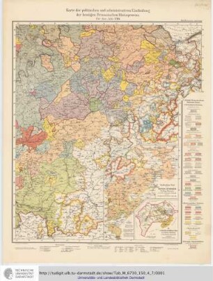
Die Karte von 1789 : Einteilung und Entwickelung der Territorien von 1600 bis 1794 / von Wilhelm Fabricius : Karte der politischen und administrativen Eintheilung der heutigen Preussischen Rheinprovinz für das Jahr 1789 Teil: 7. Kreuznach - Saarbrücken
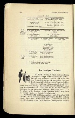
Die heutigen Zustände.
Karte der politischen und administrativen Einteilung der heutigen preußischen Rheinprovinz für das Jahr 1789, Blatt VI: Trier
Karte der politischen und administrativen Einteilung der heutigen preußischen Rheinprovinz für das Jahr 1789, Blatt IV: Köln
Karte der politischen und administrativen Einteilung der heutigen preußischen Rheinprovinz für das Jahr 1789, Blatt III: Aachen
Karte der politischen und administrativen Einteilung der heutigen preußischen Rheinprovinz für das Jahr 1789, Blatt V: Wetzlar
Karte der politischen und administrativen Einteilung der heutigen Preußischen Rheinprovinz für das Jahr 1789, Bl. I, Kleve-Düsseldorf
Karte der politischen und administrativen Einteilung der heutigen Preußischen Rheinprovinz für das Jahr 1789, Bl. I, Kleve-Düsseldorf
Karte der politischen und administrativen Einteilung der heutigen preußischen Rheinprovinz für das Jahr 1789, Blatt II: Elberfeld - Essen
Karte der politischen und administrativen Einteilung der heutigen preußischen Rheinprovinz für das Jahr 1789, Blatt VII: Kreuznach - Saarbrücken
Karte der politischen und administrativen Einteilung der heutigen preußischen Rheinprovinz für das Jahr 1789, Blatt I: Kleve - Düsseldorf
Die Gemeinde-Ordnung für die Rheinprovinz in ihrer heutigen Gestalt
Die Karte von 1789 : Einteilung und Entwickelung der Territorien von 1600 bis 1794 / von Wilhelm Fabricius : Karte der politischen und administrativen Eintheilung der heutigen Preussischen Rheinprovinz für das Jahr 1789 Teil: 7. Kreuznach - Saarbrücken