- Alternative title
-
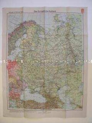
Das Europäische Rußland
- Location
-
Deutsches Historisches Museum, Berlin
- Inventory number
-
Do2 94/3489
- Measurements
-
Höhe x Breite: 102 x 76 cm
- Material/Technique
-
Papier, gedruckt
- Classification
-
Kartografie (Gattung)
- Subject (what)
-
Geographie
- Event
-
Herstellung
- (who)
-
Druckerei & Verlag: Velhagen & Klasing
- (where)
-
Bielefeld, Deutschland
- (when)
-
um 1940
- Rights
-
Deutsches Historisches Museum
- Last update
-
24.03.2023, 9:28 AM CET
Data provider
This object is provided by:
Stiftung Deutsches Historisches Museum. If you have any questions about the object, please contact the data provider.
Stiftung Deutsches Historisches Museum. If you have any questions about the object, please contact the data provider.
Object type
- Geographische Karte
Associated
- Druckerei & Verlag: Velhagen & Klasing
Time of origin
- um 1940
Other Objects (12)
Geografische Karte des europäischen Teils der UdSSR
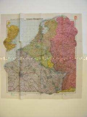
Geographische Karte von Westeuropa mit militärstrategischen Angaben
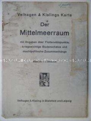
Geographische Karte des Mittelmeerraumes um 1940 mit militärstrategischen Angaben

Geographisches Handbuch, Bd. 2.. Länder- und Staatenkunde der außereuropäischen Gebiete, Wirtschaftsgeographie
Geographisches Handbuch, Bd. 1.. Allgemeine Erdkunde, Länder- und Staatenkunde von Europa
Rechenbuch für Landschulen, H. 3.
Aufgaben zum Rechnen, H. 3
Deutsches Leben, Teil 6.. Für Untersekunda
Current English für Oberschulen, T. 1
Naturgeschichte für Mittelschulen in 3 T., T. 3
Deutsche Sendung, Kl. 8
Aufgaben zum Rechnen, H. 4
Geografische Karte des europäischen Teils der UdSSR
Geographische Karte von Westeuropa mit militärstrategischen Angaben
Geographische Karte des Mittelmeerraumes um 1940 mit militärstrategischen Angaben
Geographisches Handbuch, Bd. 2.. Länder- und Staatenkunde der außereuropäischen Gebiete, Wirtschaftsgeographie
Geographisches Handbuch, Bd. 1.. Allgemeine Erdkunde, Länder- und Staatenkunde von Europa
Rechenbuch für Landschulen, H. 3.
Aufgaben zum Rechnen, H. 3
Deutsches Leben, Teil 6.. Für Untersekunda
Current English für Oberschulen, T. 1
Naturgeschichte für Mittelschulen in 3 T., T. 3
Deutsche Sendung, Kl. 8