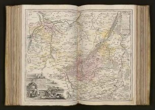
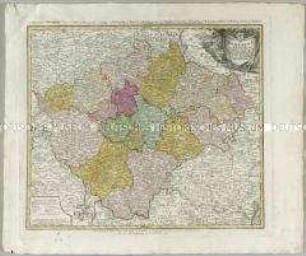
Diözesankarte
Episcopatus Hildesiensis. Mit einem Stadtplan: Ichnographia Hildesiae und einer Ansicht: Scenographia Urbis Hildesiae
- Alternative title
-
EPISCOPATUS / HILDESIENSIS / NEC NON VICINORUM STATUUM DELI- / NEATIO GEOGRAPHICA.
- Location
-
Deutsches Historisches Museum, Berlin
- Inventory number
-
Do 2006/463
- Measurements
-
Höhe x Breite: 56,8 x 64,7 cm (Blatt)
Höhe x Breite: 46,4 x 54,7 cm (Karte)
Höhe x Breite: 49,4 x 57 cm (Platte)
- Material/Technique
-
Druckfarbe, Papier, Kupferstich, koloriert
- Classification
-
Kartografie (Gattung)
- Subject (what)
-
Hildesheim
- Event
-
Herstellung
- (who)
-
Kartograf: Gerhard Justus Arenhold
Verlag: Homannsche Erben
- (where)
-
Nürnberg, Deutschland
- (when)
-
um 1760
- Rights
-
Deutsches Historisches Museum
- Last update
-
24.03.2023, 9:32 AM CET
Data provider
This object is provided by:
Stiftung Deutsches Historisches Museum. If you have any questions about the object, please contact the data provider.
Stiftung Deutsches Historisches Museum. If you have any questions about the object, please contact the data provider.
Object type
- Diözesankarte
Associated
- Kartograf: Gerhard Justus Arenhold
- Verlag: Homannsche Erben
Time of origin
- um 1760
Other Objects (12)
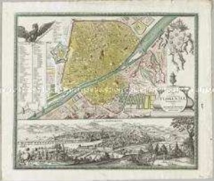
Ichnographia Urbis in Tuscia primariae Florentiae. Mit einer Ansicht: Florentz
Territorium Seculare Episcopatus Wormatiensis Tabula Geographica
Territorium Seculare Episcopatus Monasterii Munster Germanis dicti
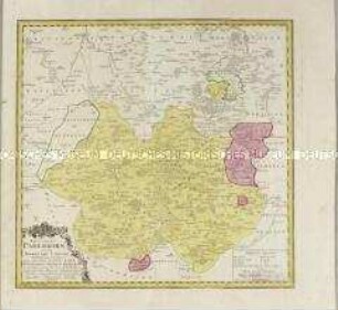
Episcopatus Paderborn nec non Abbatiae Corvei
Chorographia Territorii Naumburgo-Citiensis : Episcopatus olim nomine celebris una cum magna Confiniorum parte

Tabula Geographica Totam Borussiam ut et Districtum Notecensem. Mit einer Nebenkarte: Charte welche den Netz District vorstellet
![Karte von Kurkreis Sachsen später Wittenberger Kreis, 1:113 000, Kupferstich, 1752 : [Besondere Land-Karte des Herzogth. od. Churkreises Sachsen]Besondere Land Karte des Herzogth. od. Chvrkreises Sachsen : welcher aus den Aemtern Annaberg, Beltzig, Bitterfeld, Graefenhainchen, Liebenwerda, Pretsch, Seyda, Schlieben, Schweiniz, Daame, Iuterbock, Gommern u. Creis-Amt Witemberg zusammen gesezet ist ;nebst den Grafsch. Barby u. Baruth wie auch die Herrsch. Sonnewalde = Mappa Geographica exhibens Dvcatvm Saxoniae = Carte Géographique, ov on fait voir le Dvché de Saxonie nommé le Cercle Électorale / ans Licht gestellt von den Homaennischen Erben. - [Ca. 1:113 000]. - Norimb. : Homaennische Erben , 1752. - 1 Kt. auf 2 Bl. : kolor. Kupferst. ; Gesamtgr. 92 x 62 cm // Nullmeridian: Ferro. - NE oben. - Titel- und Erklärungskartusche unten links.- Parallelt. als Kopft. - Mit Kopft. für die Sektionen](https://iiif.deutsche-digitale-bibliothek.de/image/2/a31bf9dc-9266-42c0-87d7-70015b168cee/full/!306,450/0/default.jpg)
Karte von Kurkreis Sachsen später Wittenberger Kreis, 1:113 000, Kupferstich, 1752 : [Besondere Land-Karte des Herzogth. od. Churkreises Sachsen]Besondere Land Karte des Herzogth. od. Chvrkreises Sachsen : welcher aus den Aemtern Annaberg, Beltzig, Bitterfeld, Graefenhainchen, Liebenwerda, Pretsch, Seyda, Schlieben, Schweiniz, Daame, Iuterbock, Gommern u. Creis-Amt Witemberg zusammen gesezet ist ;nebst den Grafsch. Barby u. Baruth wie auch die Herrsch. Sonnewalde = Mappa Geographica exhibens Dvcatvm Saxoniae = Carte Géographique, ov on fait voir le Dvché de Saxonie nommé le Cercle Électorale / ans Licht gestellt von den Homaennischen Erben. - [Ca. 1:113 000]. - Norimb. : Homaennische Erben , 1752. - 1 Kt. auf 2 Bl. : kolor. Kupferst. ; Gesamtgr. 92 x 62 cm // Nullmeridian: Ferro. - NE oben. - Titel- und Erklärungskartusche unten links.- Parallelt. als Kopft. - Mit Kopft. für die Sektionen
Mappa Geographica, complectens I. Indiae Occidentalis Partem Mediam Circvm Isthmvm Panamensem II. Ipsumque Isthmum. III. Ichnographiam praecipuorum locorum & portuum ad has terras pertinentium
Carte geographique du Comté inferieur de Cazenelnbogen
Atlas Regni Bohemiae: Regni Bohemiae Circulus Pilsnensis
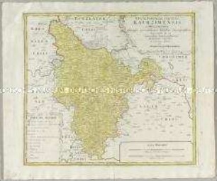
Atlas Regni Bohemiae: Regni Bohemiae Circulus Kaurzimensis
Atlas regni Bohemiae: Bohemiae Regnum in XII. Circulos divisum
Ichnographia Urbis in Tuscia primariae Florentiae. Mit einer Ansicht: Florentz
Territorium Seculare Episcopatus Wormatiensis Tabula Geographica
Territorium Seculare Episcopatus Monasterii Munster Germanis dicti
Episcopatus Paderborn nec non Abbatiae Corvei
Chorographia Territorii Naumburgo-Citiensis : Episcopatus olim nomine celebris una cum magna Confiniorum parte
Tabula Geographica Totam Borussiam ut et Districtum Notecensem. Mit einer Nebenkarte: Charte welche den Netz District vorstellet
Karte von Kurkreis Sachsen später Wittenberger Kreis, 1:113 000, Kupferstich, 1752 : [Besondere Land-Karte des Herzogth. od. Churkreises Sachsen]Besondere Land Karte des Herzogth. od. Chvrkreises Sachsen : welcher aus den Aemtern Annaberg, Beltzig, Bitterfeld, Graefenhainchen, Liebenwerda, Pretsch, Seyda, Schlieben, Schweiniz, Daame, Iuterbock, Gommern u. Creis-Amt Witemberg zusammen gesezet ist ;nebst den Grafsch. Barby u. Baruth wie auch die Herrsch. Sonnewalde = Mappa Geographica exhibens Dvcatvm Saxoniae = Carte Géographique, ov on fait voir le Dvché de Saxonie nommé le Cercle Électorale / ans Licht gestellt von den Homaennischen Erben. - [Ca. 1:113 000]. - Norimb. : Homaennische Erben , 1752. - 1 Kt. auf 2 Bl. : kolor. Kupferst. ; Gesamtgr. 92 x 62 cm // Nullmeridian: Ferro. - NE oben. - Titel- und Erklärungskartusche unten links.- Parallelt. als Kopft. - Mit Kopft. für die Sektionen
Mappa Geographica, complectens I. Indiae Occidentalis Partem Mediam Circvm Isthmvm Panamensem II. Ipsumque Isthmum. III. Ichnographiam praecipuorum locorum & portuum ad has terras pertinentium
Carte geographique du Comté inferieur de Cazenelnbogen
Atlas Regni Bohemiae: Regni Bohemiae Circulus Pilsnensis
Atlas Regni Bohemiae: Regni Bohemiae Circulus Kaurzimensis