Karten und Pläne
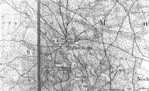
Übersichtskarte Bayerische Wuchsgebiete nach Forstamtsbereichen schematisiert. Maßstab 1:100000. 40 x 39 cm
- Reference number
-
Forstdirektion Niederbayern-Oberpfalz Kartensammlung 38
- Former reference number
-
Abgabe Forstdirektion Niederbayern-Oberpfalz 848
- Language of the material
-
ger
- Further information
-
Medium: A = Analoges Archivalie
- Context
-
Forstdirektion Niederbayern-Oberpfalz Kartensammlung
- Holding
-
Forstdirektion Niederbayern-Oberpfalz Kartensammlung
- Date of creation
-
1. April 1968
- Other object pages
- Provenance
-
Forstdirektion Niederbayern-Oberpfalz Kartensammlung
- Last update
-
26.03.2025, 12:04 PM CET
Data provider
This object is provided by:
Staatsarchiv Amberg. If you have any questions about the object, please contact the data provider.
Staatsarchiv Amberg. If you have any questions about the object, please contact the data provider.
Object type
- Karten und Pläne
Time of origin
- 1. April 1968
Other Objects (12)

Übersichtskarte zur Helmeregulierung, Maßstab 1:100000
Meßkirch, Pfullendorf, Stockach: Übersichtskarte, Maßstab: 1:100.000
Übersichtskarte, Rahmenkartenwerk Blatteinteilung 1:1500, Maßstab: 1:100.000
Rastatt: Übersichtskarte Forstbezirke im Landkreis, Maßstab: 1:100.000
Übersichtskarte der Schulbauten im Landkreis Ammerland Maßstab: 1:100.000
Übersichtskarte des Amtes Hümmling (mit Höhenangaben) Maßstab: 1:100.000
2 Markungskarten Maßstab 1:100.000
Tzschelln. Karte, Maßstab 1:100.000
Karten im Maßstab 1:100.000
Offenburg: Straßenbauamtskarte, Maßstab: 1:100.000
Donaueschingen: Straßenbauamtskarte, Maßstab: 1:100.000
Achern: Straßenbauamtskarte, Maßstab: 1:100.000
Übersichtskarte zur Helmeregulierung, Maßstab 1:100000
Meßkirch, Pfullendorf, Stockach: Übersichtskarte, Maßstab: 1:100.000
Übersichtskarte, Rahmenkartenwerk Blatteinteilung 1:1500, Maßstab: 1:100.000
Rastatt: Übersichtskarte Forstbezirke im Landkreis, Maßstab: 1:100.000
Übersichtskarte der Schulbauten im Landkreis Ammerland Maßstab: 1:100.000
Übersichtskarte des Amtes Hümmling (mit Höhenangaben) Maßstab: 1:100.000
2 Markungskarten Maßstab 1:100.000
Tzschelln. Karte, Maßstab 1:100.000
Karten im Maßstab 1:100.000
Offenburg: Straßenbauamtskarte, Maßstab: 1:100.000
Donaueschingen: Straßenbauamtskarte, Maßstab: 1:100.000