- Alternative title
-
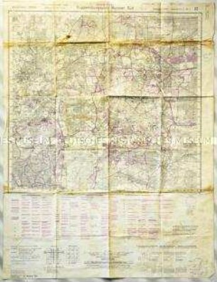
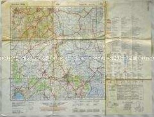
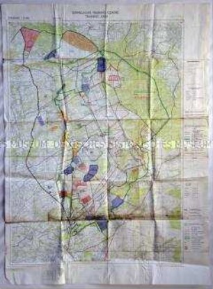
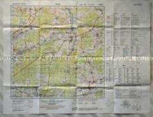
Zielskizze Truppenübungsplatz Altengrabow
- Location
-
Deutsches Historisches Museum, Berlin
- Inventory number
-
Do2 2001/117
- Measurements
-
Höhe x Breite: 81 x 83,7 cm (aufgeschlagen), Höhe: 21,5 x 15 cm (geschlossen)
- Material/Technique
-
Papier, gedruckt
- Classification
-
Kartografie (Gattung)
- Subject (what)
-
Wehrmacht (Deutschland)
Kriegsvorbereitung
- Event
-
Herstellung
- (who)
-
Verlag: Reichsamt für Landesaufnahme
- (where)
-
Berlin, Deutschland [historisch: Deutsches Reich]
- (when)
-
1937
- Rights
-
Deutsches Historisches Museum
- Last update
-
24.03.2023, 9:27 AM CET
Data provider
This object is provided by:
Stiftung Deutsches Historisches Museum. If you have any questions about the object, please contact the data provider.
Stiftung Deutsches Historisches Museum. If you have any questions about the object, please contact the data provider.
Object type
- Militärkarte
Associated
- Verlag: Reichsamt für Landesaufnahme
Time of origin
- 1937
Other Objects (12)
Topografische Karte des Truppenübungsplatzes Munster-Nord
Topografische Karte des Truppenübungsplatzes Munster-Nord
Topografische Karte des Truppenübungsplatzes Munster-Nord
Topografische Karte des NATO-Schießplatzes Bergen-Hohne
Topografische Karte der niedersächsischen Stadt Varel und Umgebung
Topografische Karte des britischen Truppenübungsplatzes "Senne" bei Paderborn
Topografische Karte des Truppenübungsplatzes bei der niedersächsischen Gemeinde Breloh
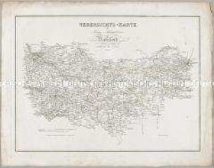
Karten und Plane zur Kriegsgeschichte von Bayern: Uebersichts-Karte von Schlesien
Karten und Plane zur Kriegsgeschichte von Bayern: Uebersichts-Karte des Kriegs-Schauplatzes in Russland
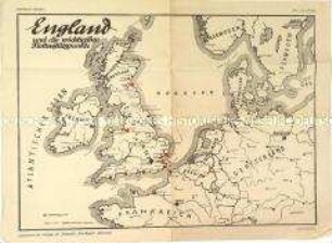
Militärische Karte mit den englischen Flottenstützpunkten
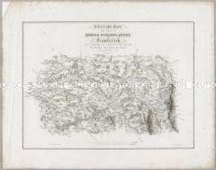
Karten und Plane zur Kriegsgeschichte von Bayern: Uebersichts-Karte eines Theils des Kriegs Schauplatzes in Frankreich

Strategische Karte für Transporte auf dem Seeweg
Topografische Karte des Truppenübungsplatzes Munster-Nord
Topografische Karte des Truppenübungsplatzes Munster-Nord
Topografische Karte des Truppenübungsplatzes Munster-Nord
Topografische Karte des NATO-Schießplatzes Bergen-Hohne
Topografische Karte der niedersächsischen Stadt Varel und Umgebung
Topografische Karte des britischen Truppenübungsplatzes "Senne" bei Paderborn
Topografische Karte des Truppenübungsplatzes bei der niedersächsischen Gemeinde Breloh
Karten und Plane zur Kriegsgeschichte von Bayern: Uebersichts-Karte von Schlesien
Karten und Plane zur Kriegsgeschichte von Bayern: Uebersichts-Karte des Kriegs-Schauplatzes in Russland
Militärische Karte mit den englischen Flottenstützpunkten
Karten und Plane zur Kriegsgeschichte von Bayern: Uebersichts-Karte eines Theils des Kriegs Schauplatzes in Frankreich