- Alternative title
-
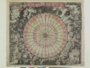
TABULA ANEMOGRAPHICA seu PYXIS NAUTICA, vulgo COMPASS. CHARTE / quâ / Ventorum Noia septem linguis graeca scil. latina, italica, hispanica, gallica, hollandica et germanica repraesentantur / succinctè elaborata
- Location
-
Deutsches Historisches Museum, Berlin
- Inventory number
-
Do 2006/650
- Measurements
-
Höhe x Breite: 58 x 72,5 cm (Blatt)
Höhe x Breite: 49 x 57,5 cm (Karte)
Höhe x Breite: 50,2 x 58,3 cm (Platte)
- Material/Technique
-
Papier, Kupferstich, koloriert
- Classification
-
Kartografie (Gattung)
- Subject (what)
-
Pyxis
Wind
Jahreszeit
- Event
-
Herstellung
- (who)
-
Stecher, Verleger, Geograph: Tobias Konrad Lotter
- (where)
-
Augsburg, Deutschland
- (when)
-
um 1760
- Rights
-
Deutsches Historisches Museum
- Last update
-
24.03.2023, 9:30 AM CET
Data provider
This object is provided by:
Stiftung Deutsches Historisches Museum. If you have any questions about the object, please contact the data provider.
Stiftung Deutsches Historisches Museum. If you have any questions about the object, please contact the data provider.
Object type
- Windkarte
Associated
- Stecher, Verleger, Geograph: Tobias Konrad Lotter
Time of origin
- um 1760
Other Objects (12)
TABULA ANEMOGRAPHICA seu PYXIS NAUTICA, vulgo COMPASS.-CHARTE
![[Eingefügt] Tabula Anemographica seu Pyxis Nautica, volgo Compass Charte.](https://iiif.deutsche-digitale-bibliothek.de/image/2/3d72c355-5bb3-4efd-817a-869653120b68/full/!306,450/0/default.jpg)
[Eingefügt] Tabula Anemographica seu Pyxis Nautica, volgo Compass Charte.

Tabula anemographica seu Pyxis Nautica : ventorum nomina sex linguis repraesentans

Tabula Anemographica seu Charta Nautica, vulgo Compass-Charte : qua Mundi Quatuor Plagae, Et Ventorum Nomina Septem Linguis Graeca scilicet, Latina, Italica, Hispanica, Gallica, Hollandica, et Germanica repraesentantur

Nautica; Numismatica: Nautica; Numismatica

Pyxis
Pyxis

Pyxis

Pyxis
Pyxis

Pyxis

Pyxis
TABULA ANEMOGRAPHICA seu PYXIS NAUTICA, vulgo COMPASS.-CHARTE
[Eingefügt] Tabula Anemographica seu Pyxis Nautica, volgo Compass Charte.
Tabula anemographica seu Pyxis Nautica : ventorum nomina sex linguis repraesentans
Tabula Anemographica seu Charta Nautica, vulgo Compass-Charte : qua Mundi Quatuor Plagae, Et Ventorum Nomina Septem Linguis Graeca scilicet, Latina, Italica, Hispanica, Gallica, Hollandica, et Germanica repraesentantur
Nautica; Numismatica: Nautica; Numismatica
Pyxis
Pyxis
Pyxis
Pyxis
Pyxis
Pyxis
Pyxis
TABULA ANEMOGRAPHICA seu PYXIS NAUTICA, vulgo COMPASS.-CHARTE
[Eingefügt] Tabula Anemographica seu Pyxis Nautica, volgo Compass Charte.
Tabula anemographica seu Pyxis Nautica : ventorum nomina sex linguis repraesentans
Tabula Anemographica seu Charta Nautica, vulgo Compass-Charte : qua Mundi Quatuor Plagae, Et Ventorum Nomina Septem Linguis Graeca scilicet, Latina, Italica, Hispanica, Gallica, Hollandica, et Germanica repraesentantur
Nautica; Numismatica: Nautica; Numismatica
Pyxis
Pyxis
Pyxis
Pyxis
Pyxis
Pyxis