Altkarte | Politik-, Rechts- und Verwaltungskarte | Thematische Karte
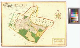
Carte von dem Bauer Dorffe Ungnade
- Location
-
Greifswald
- Collection
-
Kartensammlung des Instituts für Geographie und Geologie (Universität Greifswald)
- Inventory number
-
AFL/G26.05/113
- Measurements
-
112,8 x 102,3 cm
Maßstab [ca. 1:3.000]
- Material/Technique
-
Papier; Zeichnung
- Inscription/Labeling
-
Verantwortlichkeitsangabe: ist vermessen und angefertigt im Monat Novemb: 1785 durch C. F. v. Kaersten
- Classification
-
Kartographie
- Event
-
Herstellung
- (when)
-
1785
- Last update
-
25.03.2025, 9:45 AM CET
Data provider
This object is provided by:
Universität Greifswald. Kartensammlung des Instituts für Geographie und Geologie. If you have any questions about the object, please contact the data provider.
Universität Greifswald. Kartensammlung des Instituts für Geographie und Geologie. If you have any questions about the object, please contact the data provider.
Object type
- Altkarte; Thematische Karte; Politik-, Rechts- und Verwaltungskarte
Time of origin
- 1785
Other Objects (12)
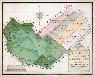
Carte von dem Boltenhagen ; gehörig zu dem Dorffe Ungnade

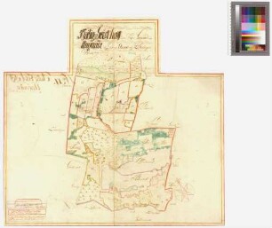
Alt-Ungnade
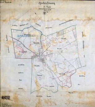
Handzeichnung Alt-Ungnade
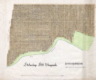
Obstanlage Alt-Ungnade

Alt Ungnade (Ungnade) Amt/Distrikt Eldena, Heilgeisthof Amt/Distrikt Greifswald
Alt Ungnade (Ungnade) Amt/Distrikt Eldena, Heilgeisthof Amt/Distrikt Greifswald
Ungnade Amt/Distrikt Franzburg
![[Sievertshagen (Sivershagen), Ungnade Amt/Distrikt Franzburg] Sywershagen Och Ungnade in Ampt Frantzborg](https://iiif.deutsche-digitale-bibliothek.de/image/2/04bad0ec-fad8-4da8-a5b4-9c376ae75787/full/!306,450/0/default.jpg)
[Sievertshagen (Sivershagen), Ungnade Amt/Distrikt Franzburg] Sywershagen Och Ungnade in Ampt Frantzborg
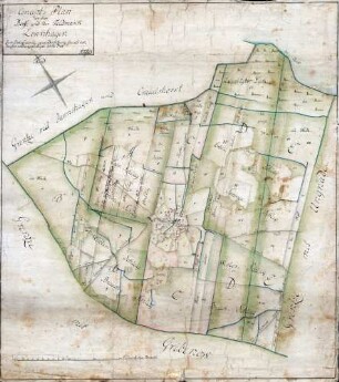
Concept Plan von dem Dorffe und der Feldmarck Levenhagen
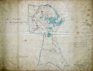
Guts- u. Drainkarte von Alt-Ungnade ; Hof I u. II

Geometrische Delineation über die im Ambte Eldena belegene und der königl: Academie zu Greifswald gehörige Güther Lebenhagen, Ungnade und Hindrichshagen

Afrika
Carte von dem Boltenhagen ; gehörig zu dem Dorffe Ungnade
Alt-Ungnade
Handzeichnung Alt-Ungnade
Obstanlage Alt-Ungnade
Alt Ungnade (Ungnade) Amt/Distrikt Eldena, Heilgeisthof Amt/Distrikt Greifswald
Alt Ungnade (Ungnade) Amt/Distrikt Eldena, Heilgeisthof Amt/Distrikt Greifswald
Ungnade Amt/Distrikt Franzburg
[Sievertshagen (Sivershagen), Ungnade Amt/Distrikt Franzburg] Sywershagen Och Ungnade in Ampt Frantzborg
Concept Plan von dem Dorffe und der Feldmarck Levenhagen
Guts- u. Drainkarte von Alt-Ungnade ; Hof I u. II
Geometrische Delineation über die im Ambte Eldena belegene und der königl: Academie zu Greifswald gehörige Güther Lebenhagen, Ungnade und Hindrichshagen