Karte / Plan
Spezialkarte von den Unter- und Ober-Salmorther nebst Griethauser Wardpolder [Mit Verzeichnis der Parzellen und ihrer Besitzer]. Angefertigt Mai 1831 von Scriba
- Former reference number
-
Nr. 539 RA. Kleve, 119 B
- Dimensions
-
Höhe: 124 cm, Breite: 59 cm, Maßstab: [ca. 1 : 5000]
- Context
-
RW Karten >> 3. Feldvermessung >> 3.6. Warden, Polder, Grinde (nach Belegenheit) >> 3.6.57. Salmorth
- Holding
-
RW Karten
- Date of creation
-
1831
- Other object pages
- Provenance
-
Diverse Registraturbildner
- Delivered via
- Last update
-
17.09.2025, 2:50 PM CEST
Data provider
This object is provided by:
Landesarchiv Nordrhein-Westfalen. Abteilung Rheinland. If you have any questions about the object, please contact the data provider.
Landesarchiv Nordrhein-Westfalen. Abteilung Rheinland. If you have any questions about the object, please contact the data provider.
Object type
- Karten / Pläne
Time of origin
- 1831
Other Objects (12)

Scriba
Scriba
Scriba
Scriba, Friedrich (1838-1920) und Familie (Linie Biedenkopf) / Gruppenaufnahme, v.l.n.r.: / vordere Reihe: Anna Scriba (* 1872); Luise Scriba geb. Breidert (1841-1932); Berta Scriba (1884-1939); Friedrich Scriba; Gustav Scriba (1875-1897) / hintere Reihe: Eduard Scriba (1869-1953); Otto Scriba (1867-1945); Ernst Scriba (* 1876); Georg Scriba (1865-1916) und Louis Scriba (1871-1905)
Scriba's Buchhandlung, C., Inhaber Fritz Scriba, Friedberg
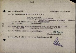
Scriba, Wilhelm
Scriba, Wilhelm
Scriba, Wilhelm
Scriba, Wilhelm
Scriba, Ludwig
Scriba Ernst
Scriba, Wilhelm
Scriba
Scriba
Scriba
Scriba, Friedrich (1838-1920) und Familie (Linie Biedenkopf) / Gruppenaufnahme, v.l.n.r.: / vordere Reihe: Anna Scriba (* 1872); Luise Scriba geb. Breidert (1841-1932); Berta Scriba (1884-1939); Friedrich Scriba; Gustav Scriba (1875-1897) / hintere Reihe: Eduard Scriba (1869-1953); Otto Scriba (1867-1945); Ernst Scriba (* 1876); Georg Scriba (1865-1916) und Louis Scriba (1871-1905)
Scriba's Buchhandlung, C., Inhaber Fritz Scriba, Friedberg
Scriba, Wilhelm
Scriba, Wilhelm
Scriba, Wilhelm
Scriba, Wilhelm
Scriba, Ludwig
Scriba Ernst