Karte / Plan
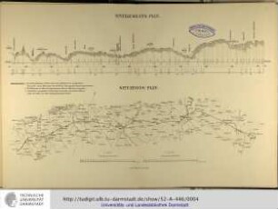
Situations- & Nivellements-Plan der dem Mühler Xhonneux zugehörigen sogenannten Keimesmühle bei Moresnet. Aufgenommen im Monat October 1855. Der Bau-Inspector Blanckenhorn
- Dimensions
-
Maßstab: [1 : 350, 1 : 100]
- Context
-
RW Karten >> 9. Gewerbe und Industrie >> 9.3. Einzelne Betriebe und Anlagen >> 9.3.5. Mühlen (Mahl-, Frucht-, Ölmühlen)
- Holding
-
RW Karten
- Date of creation
-
1855
- Other object pages
- Provenance
-
Diverse Registraturbildner
- Delivered via
- Last update
-
05.11.2025, 3:31 PM CET
Data provider
This object is provided by:
Landesarchiv Nordrhein-Westfalen. Abteilung Rheinland. If you have any questions about the object, please contact the data provider.
Landesarchiv Nordrhein-Westfalen. Abteilung Rheinland. If you have any questions about the object, please contact the data provider.
Object type
- Karten / Pläne
Time of origin
- 1855
Other Objects (12)
Nivellements-Plan / Situations-Plan

Übersichts- und Nivellements-Plan der Oberbürgermeisterei Düsseldorf

Nivellements-Plan des Regierungsgebäudes I in Sigmaringen

Übersichts- und Nivellements-Plan der Oberbürgermeisterei Duesseldorf
Chaussee Havelberg - Glöwen (R 107). Nivellements-Plan
Nivellements-Plan [und Querprofile der Berliner Straße]
Denkmal bei Hakenberg. Nivellements-Plan des großen Platzes
Nivellements-Plan der Bahnstraße zu Lobberich (mit Lageplan]
Nivellements-Plan für Pastorats-Wiese auf dem Totenkamp
Nivellements-Plan [und Querprofile der Sedanstraße und Hasselwerder Straße]

Mühler
Mühler
Nivellements-Plan / Situations-Plan
Übersichts- und Nivellements-Plan der Oberbürgermeisterei Düsseldorf
Nivellements-Plan des Regierungsgebäudes I in Sigmaringen
Übersichts- und Nivellements-Plan der Oberbürgermeisterei Duesseldorf
Chaussee Havelberg - Glöwen (R 107). Nivellements-Plan
Nivellements-Plan [und Querprofile der Berliner Straße]
Denkmal bei Hakenberg. Nivellements-Plan des großen Platzes
Nivellements-Plan der Bahnstraße zu Lobberich (mit Lageplan]
Nivellements-Plan für Pastorats-Wiese auf dem Totenkamp
Nivellements-Plan [und Querprofile der Sedanstraße und Hasselwerder Straße]
Mühler
Mühler
Nivellements-Plan / Situations-Plan
Übersichts- und Nivellements-Plan der Oberbürgermeisterei Düsseldorf
Nivellements-Plan des Regierungsgebäudes I in Sigmaringen
Übersichts- und Nivellements-Plan der Oberbürgermeisterei Duesseldorf
Chaussee Havelberg - Glöwen (R 107). Nivellements-Plan
Nivellements-Plan [und Querprofile der Berliner Straße]
Denkmal bei Hakenberg. Nivellements-Plan des großen Platzes
Nivellements-Plan der Bahnstraße zu Lobberich (mit Lageplan]
Nivellements-Plan für Pastorats-Wiese auf dem Totenkamp
Nivellements-Plan [und Querprofile der Sedanstraße und Hasselwerder Straße]
Mühler