Karte / Plan
Specimen of the Maps appearing in "The Universal Atlas": Belgium and Luxemburg. Published by Cassel & Company, Limited, Ludgate Hill, London / The Atlas Publishing Company Limited / Printed in Leipzig. Nebenkarte: Environs of Charleroi 1:500.000, 9 x 7 cm
- Reference number
-
RW Karten, 6640
- Dimensions
-
Maßstab: 1:1.000 000
- Context
-
RW Karten >> 1. Topographische Karten >> 1.3. Landesaufnahme Ausland >> 1.3.3. Europa >> 1.3.3.2. Belgien
- Holding
-
RW Karten
- Date of creation
-
[ca. 1910]
- Other object pages
- Provenance
-
Diverse Registraturbildner
- Delivered via
- Last update
-
05.11.2025, 3:59 PM CET
Data provider
This object is provided by:
Landesarchiv Nordrhein-Westfalen. Abteilung Rheinland. If you have any questions about the object, please contact the data provider.
Landesarchiv Nordrhein-Westfalen. Abteilung Rheinland. If you have any questions about the object, please contact the data provider.
Object type
- Karten / Pläne
Time of origin
- [ca. 1910]
Other Objects (12)

The Belfast Banking Company, Limited
The Cape Copper Company Limited
The Exploration Company Limited, London
The Bolivar Railway Company Limited
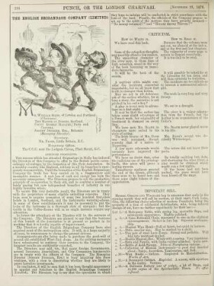
The english brigandage company (Limited)
The Dee Oil Company Limited

The International Mining Company Limited.
The cunard steamship company, limited.
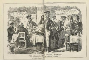
The aristocratic hotel company (limited)
The Neuchatel Asphalte Company, Limited
The East Asiatic Company Limited, Kopenhagen
The Universal Marine Insuarnce Company Limited
The Belfast Banking Company, Limited
The Cape Copper Company Limited
The Exploration Company Limited, London
The Bolivar Railway Company Limited
The english brigandage company (Limited)
The Dee Oil Company Limited
The International Mining Company Limited.
The cunard steamship company, limited.
The aristocratic hotel company (limited)
The Neuchatel Asphalte Company, Limited
The East Asiatic Company Limited, Kopenhagen