Karte / Plan
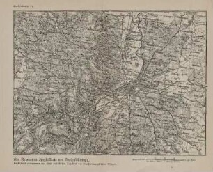
Karte der Umgebung von Detmold und Paderborn, Blatt 105 Paderborn der topographischen Spezialkarte von Deutschland von Reymann und Oesel
- Reference number
-
D 73, 4/17596
- Dimensions
-
Höhe: 38, Breite: 46, Maßstab: 1:200.000
- Further information
-
Ort: Detmold Paderborn
- Context
-
Allgemeine Kartensammlung (VERA-Verzeichnung) >> 1. Allgemeine Sammlung >> 1.15. Staaten, Welt- und Erdteile, Länder, Kreise
- Holding
-
D 73 Allgemeine Kartensammlung (VERA-Verzeichnung)
- Indexentry place
-
Detmold Paderborn
- Creator
-
Herausgeber: Reymann und Oesel
- Date of creation
-
ca. 1845
- Other object pages
- Provenance
-
Behörden, Institutionen, Einzelpersonen (Sammlungen)
- Delivered via
- Last update
-
05.11.2025, 3:06 PM CET
Data provider
This object is provided by:
Landesarchiv Nordrhein-Westfalen. Abteilung Ostwestfalen-Lippe. If you have any questions about the object, please contact the data provider.
Landesarchiv Nordrhein-Westfalen. Abteilung Ostwestfalen-Lippe. If you have any questions about the object, please contact the data provider.
Object type
- Karten / Pläne
Associated
- Herausgeber: Reymann und Oesel
Time of origin
- ca. 1845
Other Objects (12)

Reymann's Spezialkarte: Heidelberg
Reymanns topographische Spezial-Karte von Deutschland
Aus Reymanns Spezialkarte von Zentral-Europa
Reymanns topographische Spezialkarte von Deutschland und Mitteleuropa
Reymanns Spezialkarte von Mitteleuropa. Bl. 201 - 239
Reymanns Spezialkarte von Mitteleuropa. Bl. 240 - 278
Reymanns Spezialkarte von Mitteleuropa. Bl. 138 - 199
Reymanns Spezialkarte von Mitteleuropa. Bl. 71 - 137
Reymanns Spezialkarte von Mitteleuropa. Bl. 280 - 330
Reymanns Spezialkarte von Mitteleuropa. Bl. 1 - 69
Reymanns topographische Spezialkarte von Deutschland und Mitteleuropa
Reymanns topographische Spezialkarte von Deutschland und Mitteleuropa
Reymann's Spezialkarte: Heidelberg
Reymanns topographische Spezial-Karte von Deutschland
Aus Reymanns Spezialkarte von Zentral-Europa
Reymanns topographische Spezialkarte von Deutschland und Mitteleuropa
Reymanns Spezialkarte von Mitteleuropa. Bl. 201 - 239
Reymanns Spezialkarte von Mitteleuropa. Bl. 240 - 278
Reymanns Spezialkarte von Mitteleuropa. Bl. 138 - 199
Reymanns Spezialkarte von Mitteleuropa. Bl. 71 - 137
Reymanns Spezialkarte von Mitteleuropa. Bl. 280 - 330
Reymanns Spezialkarte von Mitteleuropa. Bl. 1 - 69
Reymanns topographische Spezialkarte von Deutschland und Mitteleuropa