Karten und Pläne
Plan von dem Herrschaft-Wald in dem Seelbacher Forst
Forstgrenzkarte wie Nr. 2, anderer Maßstab.
- Reference number
-
Abt. Generallandesarchiv Karlsruhe, H Selbach 3
- Dimensions
-
36,5 x 52 (Höhe x Breite)
- Further information
-
Ausführung: Handzeichnung
Orientierung: W
Originalmaßstab: 120 Ruten, 10 = 0,6 cm
- Context
-
Gemarkungspläne >> Badische Orte >> S >> Selbach, Stadt Gaggenau, RA
- Holding
-
Landesarchiv Baden-Württemberg, Abt. Generallandesarchiv Karlsruhe, H Gemarkungspläne
- Creator
-
Autor/Fotograf: J. G. Tulla
- Other object pages
- View digital item at providers-website
- Rights
-
Es gelten die Nutzungsbedingungen des Landesarchivs Baden-Württemberg.
- Last update
-
04.04.2025, 8:13 AM CEST
Data provider
This object is provided by:
Landesarchiv Baden-Württemberg. If you have any questions about the object, please contact the data provider.
Landesarchiv Baden-Württemberg. If you have any questions about the object, please contact the data provider.
Object type
- Karten und Pläne
Associated
- Autor/Fotograf: J. G. Tulla
Other Objects (12)

Plan von dem Herrschaft-Wald in dem Seelbacher Forst

Plan über die Seelbacher Kirchengüter

Karte der herrschaftlichen Höhenwaldung im Seelbacher Forst
Regulierung der Viehtrift im Seelbacher Wald (Revier Freudenberg)
Grundzins der Seelbacher Mühle
Seelbacher Mühle; Herborn, Mühle
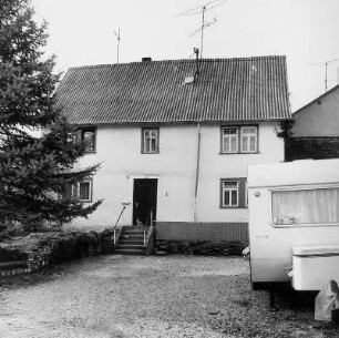
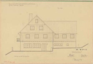
Villmar, Seelbacher Straße 2
Grenzbeschreibung des Seelbacher Grundes
Seelbacher Weiher; Hotel Am Weiher: Erweiterungsbau des Gaststättengebäudes am Freibad Seelbacher-Weiher
Seelbacher Weiher; Hotel Am Weiher: Erweiterungsbau des Gaststättengebäudes am Freibad Seelbacher-Weiher
Seelbacher Weiher; Hotel Am Weiher: Erweiterungsbau des Gaststättengebäudes am Freibad Seelbacher-Weiher
Seelbacher Weiher; Hotel Am Weiher: Erweiterungsbau des Gaststättengebäudes am Freibad Seelbacher-Weiher
Plan von dem Herrschaft-Wald in dem Seelbacher Forst
Plan über die Seelbacher Kirchengüter
Karte der herrschaftlichen Höhenwaldung im Seelbacher Forst
Regulierung der Viehtrift im Seelbacher Wald (Revier Freudenberg)
Grundzins der Seelbacher Mühle
Seelbacher Mühle; Herborn, Mühle
Villmar, Seelbacher Straße 2
Grenzbeschreibung des Seelbacher Grundes
Seelbacher Weiher; Hotel Am Weiher: Erweiterungsbau des Gaststättengebäudes am Freibad Seelbacher-Weiher
Seelbacher Weiher; Hotel Am Weiher: Erweiterungsbau des Gaststättengebäudes am Freibad Seelbacher-Weiher
Seelbacher Weiher; Hotel Am Weiher: Erweiterungsbau des Gaststättengebäudes am Freibad Seelbacher-Weiher