Verzeichnung
Das Dorf Wechloy in der Stadt Oldenburg Maßstab: 1:5000 Entwurf/Bearbeitung: Dr. med. H. Steenken Zeichner. E. Nordbruch 1. Das Dorf Wechloy der Rittergüter bis 1500 2. Die Kündigung Wechloy bis 1700 3. Die Vogtei (Bauerschaft) Wechloy bis 1900 4. Der Stadtteil Wechloy 1924 - 1984
- Reference number
-
NLA OL, K-ZE, Best. 298 Z Nr. 2739
- Further information
-
Identifikation: Band:
- Context
-
Zentraler Kartenbestand Oldenburg >> 5 Bezirksregierung Weser-Ems >> 5.11 Stadt Oldenburg >> 5.11.5 Feldmarken, Stadt- und Ortspläne, Flurstücke
- Holding
-
NLA OL, K-ZE Zentraler Kartenbestand Oldenburg
- Indexentry person
-
Nordbruch, E., Zeichner
Steenken, H., Dr. med.
- Indexentry place
-
Wechloy, Karte
Wechloy, Vogtei, Karte
- Date of creation
-
- 1984
- Other object pages
- Last update
-
16.06.2025, 11:09 AM CEST
Data provider
This object is provided by:
Niedersächsisches Landesarchiv. If you have any questions about the object, please contact the data provider.
Niedersächsisches Landesarchiv. If you have any questions about the object, please contact the data provider.
Object type
- Verzeichnung
Time of origin
- - 1984
Other Objects (12)

Steenken, Bernhard
Steenken Dr.
Steenken, Gustav
Abgangszeugnis Christel Steenken
Abgangszeugnis Hans Steenken
Abgangszeugnis Josef Steenken
Steenken, Renata geb. Schenk
Abgangszeugnis Hans Helmuth Steenken
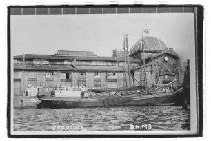
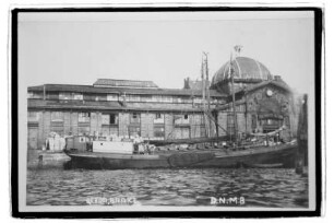
Deutsche Hochseefischerei Bolte & Steenken, Bremerhaven
Gerda (1910), Joh. Steenken, Brake
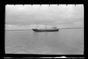
Germania (1956), F. Steenken, Elsfleth
Gerda (1910), Johann Steenken, Brake
Steenken, Bernhard
Steenken Dr.
Steenken, Gustav
Abgangszeugnis Christel Steenken
Abgangszeugnis Hans Steenken
Abgangszeugnis Josef Steenken
Steenken, Renata geb. Schenk
Abgangszeugnis Hans Helmuth Steenken
Deutsche Hochseefischerei Bolte & Steenken, Bremerhaven
Gerda (1910), Joh. Steenken, Brake
Germania (1956), F. Steenken, Elsfleth