Karte / Plan
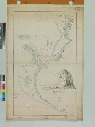
Situation des Rheinstroms vom Hönnepeler Deich bis zum Griether Kanal. D XVIII Nr. 44; III f 3 135; I 74/112
- Reference number
-
RW Karten, 2390
- Dimensions
-
Höhe: 66 cm , Breite: 40 cm, Maßstab: 1 : 5000
- Context
-
RW Karten >> 5. Gewässer >> 5.2. Rhein >> 5.2.2. Kürzere Stromabschnitte
- Holding
-
RW Karten
- Date of creation
-
[um 1820]
- Other object pages
- Provenance
-
Diverse Registraturbildner
- Delivered via
- Last update
-
05.11.2025, 3:28 PM CET
Data provider
This object is provided by:
Landesarchiv Nordrhein-Westfalen. Abteilung Rheinland. If you have any questions about the object, please contact the data provider.
Landesarchiv Nordrhein-Westfalen. Abteilung Rheinland. If you have any questions about the object, please contact the data provider.
Object type
- Karten / Pläne
Time of origin
- [um 1820]
Other Objects (12)

Fußgängerweg zwischen dem Rheinstrom und Laar; Beeckerwerther Deich zum Haus Knipp
Rheinstrom

Diverses (Nr. 112-135)
Urkundensammlung, Nr. 112 - 135
Situation der Außen-Deiche vor Süder-Dithmarschen
Rheinstrom Überwachung
Rhein-Strom
Rheinstrom, Lise
"Rheinstrom 10"
Rheinstrom, Ruth
Rheinstrom-Jagdverpachtung

Leipzig. - Rheinstrom.
Fußgängerweg zwischen dem Rheinstrom und Laar; Beeckerwerther Deich zum Haus Knipp
Rheinstrom
Diverses (Nr. 112-135)
Urkundensammlung, Nr. 112 - 135
Situation der Außen-Deiche vor Süder-Dithmarschen
Rheinstrom Überwachung
Rhein-Strom
Rheinstrom, Lise
"Rheinstrom 10"
Rheinstrom, Ruth
Rheinstrom-Jagdverpachtung