Karte / Plan
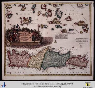
Kreta (Candia), Topographie und Territorien: Insula Creta hodie in sua IV. Territoria divisa cum adjacentibus Aegei Maris Insulis ac praesertim nuperrime ex abysso pelagi emergente Nova Santorini Insula. occasione cuius tam stupendi Naturae phaenomeni tabulam hanc Curiosis spectandam edidit Ioh. Bapt. Homannus Norimbergae
- Former reference number
-
Bibliothek Harff-Dreiborn, Landkarten Nr. 81
- Dimensions
-
Höhe: 48 cm , Breite: 57 cm , Maßstab: in italineischen, germanischen und gallischen Meilen
- Context
-
RW Karten >> 1. Topographische Karten >> 1.3. Landesaufnahme Ausland >> 1.3.3. Europa
- Holding
-
RW Karten
- Date of creation
-
(ca. 1707)
- Other object pages
- Provenance
-
Diverse Registraturbildner
- Delivered via
- Last update
-
17.09.2025, 3:30 PM CEST
Data provider
This object is provided by:
Landesarchiv Nordrhein-Westfalen. Abteilung Rheinland. If you have any questions about the object, please contact the data provider.
Landesarchiv Nordrhein-Westfalen. Abteilung Rheinland. If you have any questions about the object, please contact the data provider.
Object type
- Karten / Pläne
Time of origin
- (ca. 1707)
Other Objects (12)
Insula Creta hodie Candia.

De Candia sive Creta insula.

De Candia sive Creta insula.
Haec est illa insugnis insula Creta, ...
Creta Insula, hodie Cādia, in medio pōto sita est … exportatur

Cap. XVI. De Creta Insula, Deque aliis plurimis ad eam pertineutibus
Insula Candia

Insula Britannicae

Insula Tiberina

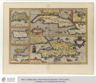
Cuba Insula
Cuba Insula

§. Insula. 22.
Insula Creta hodie Candia.
De Candia sive Creta insula.
De Candia sive Creta insula.
Haec est illa insugnis insula Creta, ...
Creta Insula, hodie Cādia, in medio pōto sita est … exportatur
Cap. XVI. De Creta Insula, Deque aliis plurimis ad eam pertineutibus
Insula Candia
Insula Britannicae
Insula Tiberina
Cuba Insula
Cuba Insula