Karte / Plan
Situationsplan und Profilriss zur Chaussierung des Weges durch das Siekholz, (Amt Blomberg/Amt Schieder),. Profilriss ca. 1:1.930 und 1:121
- Reference number
-
D 73, 4/6136
- Dimensions
-
Höhe: 55, Breite: 158
- Context
-
Allgemeine Kartensammlung (bisherige Kartei) >> 22. Tit. 4 (noch nicht klassifiziert) >> 22.15. Nr. 6001 - 6200
- Holding
-
D 73 Allgemeine Kartensammlung (bisherige Kartei)
- Date of creation
-
(ca. 19. Jh.)
- Other object pages
- Provenance
-
Behörden, Institutionen, Einzelpersonen (Sammlungen)
- Delivered via
- Last update
-
05.11.2025, 3:28 PM CET
Data provider
This object is provided by:
Landesarchiv Nordrhein-Westfalen. Abteilung Ostwestfalen-Lippe. If you have any questions about the object, please contact the data provider.
Landesarchiv Nordrhein-Westfalen. Abteilung Ostwestfalen-Lippe. If you have any questions about the object, please contact the data provider.
Object type
- Karten / Pläne
Time of origin
- (ca. 19. Jh.)
Other Objects (12)

Plan zur Lage Wegeanlage von Kohlstädt nach Oesterholz u. w.,. Profilriss, Aufriss und Grundriss (Brücken) Situationsplan (Amt Horn),. Höhenmaßstab Profilriss ca. 1:121, Längenmaßstab Profilriss ca. 1:1.930, Situationsplan ca. 1:1.930, Aufriss, Grundriss ca. 1:60
Situationsplan und Profilriss zum Ausbau der Gemeindechaussee von Maspe über Freismissen nach Borkhausen, (Amt Blomberg/Amt Schieder),. Profilriss ca. 1:1.930 und 1:121
Situationsplan und Profilriss zur Chaussierung des Weges durch das Siekholz, (Amt Blomberg/Amt Schieder),. Situationsplan
Plan und Profilriss zur Verbesserung der Einfahrt in Blomberg, hier in das Heutor projektiert (Stadt und Amt Blomberg),. Profilriss, Profillänge ca. 1:1.930 und ca. 1:121
Profilriss verschiedener Schächte
Profilriss August-Schacht
Profilriss des Eduard-Schachtes
Nivellements- und Situationsplan und Profilriss zu der Chaussierung des Wegs von Wörderfeld nach Falkenhagen (Amt Schwalenberg),. mit Höhendarstellung,. Situationsplan, Längenmaßstab ca. 1:1.930
Nivellements- und Situationsplan und zu der Chaussierung des Wegs von Wörderfeld nach Falkenhagen (Amt Schwalenberg),. Profilriss, Längenprofil und Querprofile, Längenmaßstab ca. 1:1.930
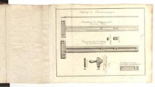
Fig. 2. Profilriss des Distanzenmessers
Profilriss von den Freiesleben-Schächten
Grund- und Profilriss vom Langentaler Revier
Plan zur Lage Wegeanlage von Kohlstädt nach Oesterholz u. w.,. Profilriss, Aufriss und Grundriss (Brücken) Situationsplan (Amt Horn),. Höhenmaßstab Profilriss ca. 1:121, Längenmaßstab Profilriss ca. 1:1.930, Situationsplan ca. 1:1.930, Aufriss, Grundriss ca. 1:60
Situationsplan und Profilriss zum Ausbau der Gemeindechaussee von Maspe über Freismissen nach Borkhausen, (Amt Blomberg/Amt Schieder),. Profilriss ca. 1:1.930 und 1:121
Situationsplan und Profilriss zur Chaussierung des Weges durch das Siekholz, (Amt Blomberg/Amt Schieder),. Situationsplan
Plan und Profilriss zur Verbesserung der Einfahrt in Blomberg, hier in das Heutor projektiert (Stadt und Amt Blomberg),. Profilriss, Profillänge ca. 1:1.930 und ca. 1:121
Profilriss verschiedener Schächte
Profilriss August-Schacht
Profilriss des Eduard-Schachtes
Nivellements- und Situationsplan und Profilriss zu der Chaussierung des Wegs von Wörderfeld nach Falkenhagen (Amt Schwalenberg),. mit Höhendarstellung,. Situationsplan, Längenmaßstab ca. 1:1.930
Nivellements- und Situationsplan und zu der Chaussierung des Wegs von Wörderfeld nach Falkenhagen (Amt Schwalenberg),. Profilriss, Längenprofil und Querprofile, Längenmaßstab ca. 1:1.930
Fig. 2. Profilriss des Distanzenmessers
Profilriss von den Freiesleben-Schächten