Archivale
Untere Havelwasserstraße km neu 127,9 - 128,7; Untere Havel km 127,9 - 128,7 (später Bl. 26); Gülper Havel km 127,2 - 128,3; Warnauer Vorfluter km 5,6 - 6,5
- Reference number
-
57 WSD K 5429 A
- Context
-
Rep. 57 Wasserstraßendirektion Potsdam - Karten >> Wasserstraßenamt Rathenow >> Vermessungs- und Kartenwesen >> Untere Havel >> Lagepläne mit Einmündung Hohennauener Kanal
- Holding
-
57 WSD K (15603) Rep. 57 Wasserstraßendirektion Potsdam - Karten
- Date of creation
-
1902-1929
- Other object pages
- Last update
-
07.04.2025, 11:38 AM CEST
Data provider
This object is provided by:
Brandenburgisches Landeshauptarchiv. If you have any questions about the object, please contact the data provider.
Brandenburgisches Landeshauptarchiv. If you have any questions about the object, please contact the data provider.
Object type
- Archivale
Time of origin
- 1902-1929
Other Objects (12)

Unterer Havelwasserstraße km neu 127,9 - 128,5; km alt 32,9 - 33,9
km 127,9-128,6 Grundeigentumskarte der Gemarkung Kattenstroth
Untere Havelwasserstraße km neu 127,9 - 128,7, alt 32,6 - 33,4 (später Bl. 26 Wanau II); Untere Havel km 32,6 - 33,4 Gülper Havel km 0,3 - 1,4; Warnauer Vorfluter km 5,6 - 6,5
Untere Havelwasserstraße. Bl. 27 - Untere Havel km 128,7 - 130,0 Schleuse Garz; Schleusenkanal Garz 128,7 - 130,0; Gülper Havel 128,3 - 128,6; Warnauer Vorfluter km 6,3 - 7,3
Absteckungspläne: - vom Unterkanal - km 128 + 855 bis km 129 + 540 - km 127 + 605 bis km 128 + 120; Profile 1 - 46 - ein weiterer Absteckungsplan
127. 128
127-128
127-128
Langgrien (Planquadrat 127/9)
km 127,5-128,3 Grunderwerbskarte der Gemarkung Paderborn, Blatt 1
127-128 Werbung
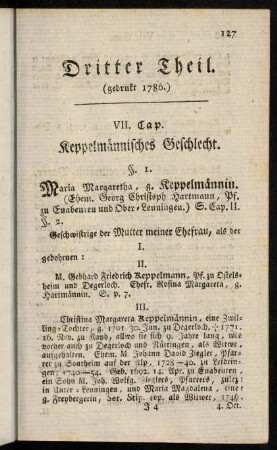
127-128, §. 1.
Unterer Havelwasserstraße km neu 127,9 - 128,5; km alt 32,9 - 33,9
km 127,9-128,6 Grundeigentumskarte der Gemarkung Kattenstroth
Untere Havelwasserstraße km neu 127,9 - 128,7, alt 32,6 - 33,4 (später Bl. 26 Wanau II); Untere Havel km 32,6 - 33,4 Gülper Havel km 0,3 - 1,4; Warnauer Vorfluter km 5,6 - 6,5
Untere Havelwasserstraße. Bl. 27 - Untere Havel km 128,7 - 130,0 Schleuse Garz; Schleusenkanal Garz 128,7 - 130,0; Gülper Havel 128,3 - 128,6; Warnauer Vorfluter km 6,3 - 7,3
Absteckungspläne: - vom Unterkanal - km 128 + 855 bis km 129 + 540 - km 127 + 605 bis km 128 + 120; Profile 1 - 46 - ein weiterer Absteckungsplan
127. 128
127-128
127-128
Langgrien (Planquadrat 127/9)
km 127,5-128,3 Grunderwerbskarte der Gemarkung Paderborn, Blatt 1
127-128 Werbung