Karte / Plan
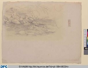
Brouillon IV. Die Partie des Alten Rheins bei Lobith bis zur Wildbach. Aufgenommen im Monat Sept. 1820 von W. Vogelsang
- Reference number
-
RW Karten, 681
- Dimensions
-
Höhe: 40 cm, Breite: 68 cm
- Context
-
RW Karten >> 5. Gewässer >> 5.2. Rhein >> 5.2.9. Waal, Nederrijn, Ijssel
- Holding
-
RW Karten
- Date of creation
-
1820
- Other object pages
- Provenance
-
Diverse Registraturbildner
- Delivered via
- Last update
-
05.11.2025, 3:32 PM CET
Data provider
This object is provided by:
Landesarchiv Nordrhein-Westfalen. Abteilung Rheinland. If you have any questions about the object, please contact the data provider.
Landesarchiv Nordrhein-Westfalen. Abteilung Rheinland. If you have any questions about the object, please contact the data provider.
Object type
- Karten / Pläne
Time of origin
- 1820
Other Objects (12)

Wildbach
Wildbach

Wildbach

Wildbach

Wildbach
Wildbach
Wildbach
Wildbach
Wildbach

Talbrücke, Wildbach
Ortsstatut Wildbach

Talbrücke Wildbach
Wildbach
Wildbach
Wildbach
Wildbach
Wildbach
Wildbach
Wildbach
Wildbach
Wildbach
Talbrücke, Wildbach
Ortsstatut Wildbach
Talbrücke Wildbach
Wildbach
Wildbach
Wildbach
Wildbach
Wildbach
Wildbach
Wildbach
Wildbach
Wildbach
Talbrücke, Wildbach
Ortsstatut Wildbach