Karte / Plan
Karte der Chaussee von Vlotho nach Varenholz im Dorf Erder (Amt Varenholz), Lageplan und 2 Längenprofile, Lageplan ca. 1:2.105, Profilhöhen ca. 1:264
- Reference number
-
D 73, 4/6078
- Context
-
Allgemeine Kartensammlung (bisherige Kartei) >> 22. Tit. 4 (noch nicht klassifiziert) >> 22.15. Nr. 6001 - 6200
- Holding
-
D 73 Allgemeine Kartensammlung (bisherige Kartei)
- Date of creation
-
1851
- Other object pages
- Provenance
-
Behörden, Institutionen, Einzelpersonen (Sammlungen)
- Delivered via
- Last update
- 05.11.2025, 3:36 PM CET
Data provider
This object is provided by:
Landesarchiv Nordrhein-Westfalen. Abteilung Ostwestfalen-Lippe. If you have any questions about the object, please contact the data provider.
Landesarchiv Nordrhein-Westfalen. Abteilung Ostwestfalen-Lippe. If you have any questions about the object, please contact the data provider.
Object type
- Karten / Pläne
Time of origin
- 1851
Other Objects (12)
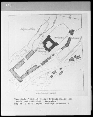
Varenholz, Lageplan des Schlosses

Karte einer Weganlage Almena - Fütig (Amt Varenholz/Amt Sternberg-Barntrup), Längenprofil des neu anzulegenden und des alten Wegs, Querschnitt, Lageplan,. ca. 1:2.105, ca. 1:363, ca. 1:4.246, ca. 1:580
Begradigung der Chaussee bei der Meierei Varenholz,. Lageplan und Profilriss, ca. 1:700, ca. 1:90
Karte von der Meierei Varenholz: Lageplan (Grundriss) vom hochgräflichen Schloss und der Meierei Varenholz
Entwürfe zu einer Kommunalweganlage durch Kalldorf (Amt Varenholz),. Situation des Dorfs und 2 Längenprofile, Situationsplan ca. 1:3.200, Profilhöhen ca. 1:537, Profillängen ca. 1:4.246
Geborene (varenholz) (Gemeinde: Varenholz)
Geborene (Varenholz) (Gemeinde: Varenholz)

Brand, Drechsler zu Varenholz gegen Obenhaus zu Varenholz, Schmidt in Varenholz, Bunte zu Varenholz, Schreier zu Varenholz
Entwurf zur Rektifikation der Chaussee vor Langenholzhausen (Amt Varenholz), Lageplan der Chaussee bzw. der neu zu bauenden Strecke, Lageplan ca. 1:1.289, Profillängen ca. 1:2.158, Profilhöhen ca. 1:161
Varenholz: Der Totenhof in Varenholz
Varenholz
Varenholz
Varenholz, Lageplan des Schlosses
Karte einer Weganlage Almena - Fütig (Amt Varenholz/Amt Sternberg-Barntrup), Längenprofil des neu anzulegenden und des alten Wegs, Querschnitt, Lageplan,. ca. 1:2.105, ca. 1:363, ca. 1:4.246, ca. 1:580
Begradigung der Chaussee bei der Meierei Varenholz,. Lageplan und Profilriss, ca. 1:700, ca. 1:90
Karte von der Meierei Varenholz: Lageplan (Grundriss) vom hochgräflichen Schloss und der Meierei Varenholz
Entwürfe zu einer Kommunalweganlage durch Kalldorf (Amt Varenholz),. Situation des Dorfs und 2 Längenprofile, Situationsplan ca. 1:3.200, Profilhöhen ca. 1:537, Profillängen ca. 1:4.246
Geborene (varenholz) (Gemeinde: Varenholz)
Geborene (Varenholz) (Gemeinde: Varenholz)
Brand, Drechsler zu Varenholz gegen Obenhaus zu Varenholz, Schmidt in Varenholz, Bunte zu Varenholz, Schreier zu Varenholz
Entwurf zur Rektifikation der Chaussee vor Langenholzhausen (Amt Varenholz), Lageplan der Chaussee bzw. der neu zu bauenden Strecke, Lageplan ca. 1:1.289, Profillängen ca. 1:2.158, Profilhöhen ca. 1:161
Varenholz: Der Totenhof in Varenholz
Varenholz