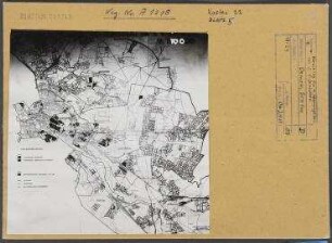
Dortmund, Stadtplan, Östlicher Teil
Darin: Kartengrundlage: Stadtplanwerk Ruhrgebiet
- Reference number
-
200/01, 00/283
- Former reference number
-
200 - Ca 67
Registratursignatur: StA 62: 2.2.112
- Formal description
-
Mittige Knickfalten
- Further information
-
Maßstab: M. 1 : 15.000
- Context
-
Allgemeine Kartensammlung: Drucke und Reproduktionen (Einzelkarten) >> 01 ALLGEMEINE ÜBERSICHTSKARTEN UND -PLÄNE >> 01.01 Gesamtes Stadtgebiet Dortmund >> 01.01.07 Ab 1975
- Holding
-
200/01 Allgemeine Kartensammlung: Drucke und Reproduktionen (Einzelkarten)
- Creator
-
Autor: Herausgeber: Stadt Dortmund, Vermessungs- und Katasteramt, in Mairs Geographischer Verlag, Stuttgart
Kartographie und Druck: Stadt Dortmund, Vermessungs- und Katasteramt
- Date of creation
-
1983
- Other object pages
- Delivered via
- Last update
-
17.09.2025, 2:38 PM CEST
Data provider
This object is provided by:
Stadtarchiv Dortmund. If you have any questions about the object, please contact the data provider.
Stadtarchiv Dortmund. If you have any questions about the object, please contact the data provider.
Object type
- Sonstiges
Associated
- Autor: Herausgeber: Stadt Dortmund, Vermessungs- und Katasteramt, in Mairs Geographischer Verlag, Stuttgart<br />Kartographie und Druck: Stadt Dortmund, Vermessungs- und Katasteramt
Time of origin
- 1983
Other Objects (12)

Dortmund, Stadtplan, Östlicher Teil
Dortmund, Stadtplan, Östlicher Teil
Dortmund, Stadtplan, Östlicher Teil
. Stadtplan von Wiesbaden: Erbenheim (östlicher Teil)
Stadtplan Hamborn, östlicher Teil. 1:5000
Dortmund, Stadtplan, Westlicher Teil
Dortmund, Stadtplan, Westlicher Teil
Dortmund, Stadtplan, Westlicher Teil
Stadtplan von Berlin, Verwaltungsbezirk Zehlendorf, östlicher Teil
Stadtplan von Berlin. Verwaltungsbezirk Zehlendorf östlicher Teil
Stadtplan. Berlin, östliche Stadthälfte
Dortmund, Stadtplan
Dortmund, Stadtplan, Östlicher Teil
Dortmund, Stadtplan, Östlicher Teil
Dortmund, Stadtplan, Östlicher Teil
. Stadtplan von Wiesbaden: Erbenheim (östlicher Teil)
Stadtplan Hamborn, östlicher Teil. 1:5000
Dortmund, Stadtplan, Westlicher Teil
Dortmund, Stadtplan, Westlicher Teil
Dortmund, Stadtplan, Westlicher Teil
Stadtplan von Berlin, Verwaltungsbezirk Zehlendorf, östlicher Teil
Stadtplan von Berlin. Verwaltungsbezirk Zehlendorf östlicher Teil
Stadtplan. Berlin, östliche Stadthälfte