Karte / Plan
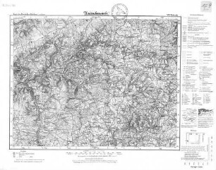
km 18-28 Höhen- und Lageplan Gemeinde Malmedy und Gemeinde Burnenville Blatt 3
- Former reference number
-
1550005838
- Context
-
Bahndirektion Köln, Karten und Pläne, Band 5 >> 1. Bahnstrecken >> 1.64. Strecken ohne Kennzeichnung >> 1.64.2. Waimes-Stavelot >> 1.64.2.1. Höhenlageplan (Iuh/Iulh)
- Holding
-
BR 1210 Bahndirektion Köln, Karten und Pläne, Band 5
- Date of creation
-
1905-1907
- Other object pages
- Provenance
-
Bahndirektion Köln
- Delivered via
- Last update
-
17.09.2025, 3:31 PM CEST
Data provider
This object is provided by:
Landesarchiv Nordrhein-Westfalen. Abteilung Rheinland. If you have any questions about the object, please contact the data provider.
Landesarchiv Nordrhein-Westfalen. Abteilung Rheinland. If you have any questions about the object, please contact the data provider.
Object type
- Karten / Pläne
Time of origin
- 1905-1907
Other Objects (12)

km 18-28 Höhen- und Lageplan Gemeinde Malmedy und Gemeinde Burnenville Blatt 3
km 7-18 Höhen- und Lageplan Strecke Malmedy-Reichsgrenze (Stavelot) Blatt 2
km 7-18 Höhen- und Lageplan Strecke Malmedy-Reichsgrenze (Stavelot) Blatt 2
Gemeinde Amel (Kreis Malmedy)
480. Malmedy: Malmedy
Malmedy: Eigentumsstreitigkeiten der Gemeinde Malmedy mit den zur Stadt gehörigenden Dörfern
Malmedy
Malmedy

Malmedy
Malmedy
Malmedy
Malmedy
km 18-28 Höhen- und Lageplan Gemeinde Malmedy und Gemeinde Burnenville Blatt 3
km 7-18 Höhen- und Lageplan Strecke Malmedy-Reichsgrenze (Stavelot) Blatt 2
km 7-18 Höhen- und Lageplan Strecke Malmedy-Reichsgrenze (Stavelot) Blatt 2
Gemeinde Amel (Kreis Malmedy)
480. Malmedy: Malmedy
Malmedy: Eigentumsstreitigkeiten der Gemeinde Malmedy mit den zur Stadt gehörigenden Dörfern
Malmedy
Malmedy
Malmedy
Malmedy
Malmedy
Malmedy
km 18-28 Höhen- und Lageplan Gemeinde Malmedy und Gemeinde Burnenville Blatt 3
km 7-18 Höhen- und Lageplan Strecke Malmedy-Reichsgrenze (Stavelot) Blatt 2
km 7-18 Höhen- und Lageplan Strecke Malmedy-Reichsgrenze (Stavelot) Blatt 2
Gemeinde Amel (Kreis Malmedy)
480. Malmedy: Malmedy
Malmedy: Eigentumsstreitigkeiten der Gemeinde Malmedy mit den zur Stadt gehörigenden Dörfern
Malmedy
Malmedy
Malmedy
Malmedy
Malmedy